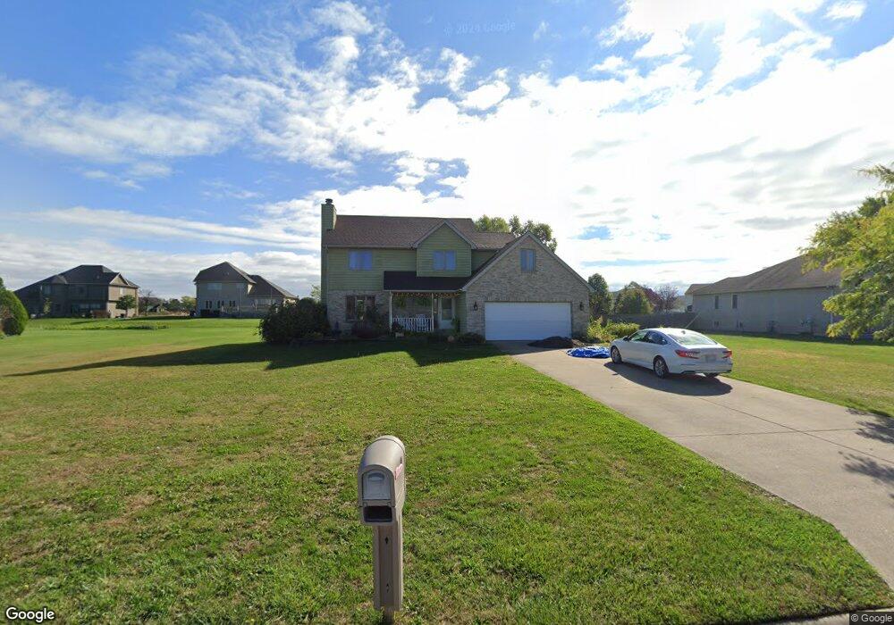
11081 Miami St Crown Point, IN 46307
Estimated Value: $358,000 - $447,000
4
Beds
3
Baths
2,041
Sq Ft
$195/Sq Ft
Est. Value
About This Home
This home is located at 11081 Miami St, Crown Point, IN 46307 and is currently estimated at $397,717, approximately $194 per square foot. 11081 Miami St is a home located in Lake County with nearby schools including Winfield Elementary School, Jerry Ross Elementary School, and Colonel John Wheeler Middle School.
Ownership History
Date
Name
Owned For
Owner Type
Purchase Details
Closed on
Mar 25, 2011
Sold by
Lewis Mark A and Lewis Linda D
Bought by
Barski Robert R
Current Estimated Value
Home Financials for this Owner
Home Financials are based on the most recent Mortgage that was taken out on this home.
Original Mortgage
$232,350
Outstanding Balance
$161,515
Interest Rate
5.04%
Mortgage Type
VA
Estimated Equity
$236,202
Create a Home Valuation Report for This Property
The Home Valuation Report is an in-depth analysis detailing your home's value as well as a comparison with similar homes in the area
Home Values in the Area
Average Home Value in this Area
Purchase History
| Date | Buyer | Sale Price | Title Company |
|---|---|---|---|
| Barski Robert R | -- | Chicago Title Insurance Co |
Source: Public Records
Mortgage History
| Date | Status | Borrower | Loan Amount |
|---|---|---|---|
| Open | Barski Robert R | $232,350 |
Source: Public Records
Tax History Compared to Growth
Tax History
| Year | Tax Paid | Tax Assessment Tax Assessment Total Assessment is a certain percentage of the fair market value that is determined by local assessors to be the total taxable value of land and additions on the property. | Land | Improvement |
|---|---|---|---|---|
| 2024 | $8,861 | $358,600 | $63,400 | $295,200 |
| 2023 | $3,629 | $328,200 | $63,400 | $264,800 |
| 2022 | $3,276 | $294,200 | $43,600 | $250,600 |
| 2021 | $2,714 | $244,800 | $43,600 | $201,200 |
| 2020 | $2,450 | $226,600 | $43,600 | $183,000 |
| 2019 | $2,940 | $225,800 | $43,300 | $182,500 |
| 2018 | $3,167 | $223,300 | $43,300 | $180,000 |
| 2017 | $2,502 | $222,600 | $43,300 | $179,300 |
| 2016 | $2,453 | $215,900 | $43,300 | $172,600 |
| 2014 | $2,364 | $219,000 | $43,300 | $175,700 |
| 2013 | $2,493 | $224,900 | $43,300 | $181,600 |
Source: Public Records
Map
Nearby Homes
- 11059 Wynbrook Dr
- 10971 Wynbrook Dr
- 7423 Macedon St
- Martin Plan at Estates of Wynbrook
- 7501 E 111th Ln Unit 61
- 7556 E 111th Ln
- 7615 E 111th Ln
- 6889 E 109th Ave
- 7760 E 111th Place
- 8610 E 109th Ave
- 10845 Park St
- 6800 E 109th Ave
- 11238 Pike Place
- 11214 Putnam Dr
- 10838 Pike St
- 7851 E 108th Ave
- 7674 E 108th Ave
- 6448 E 114th Place
- 10785 Pike St
- 7264 E 115th Ave
- 11091 Miami St
- 11063 Miami St
- 11090 Wynbrook Dr
- 11072 Wynbrook Dr
- 11107 Miami St
- 11045 Miami St
- 11052 Miami St
- 11125 Wynbrook Dr
- 11054 Wynbrook Dr
- 11092 Miami St
- 11123 Miami St
- 11032 Miami St
- 11036 Wynbrook Dr
- 11025 Miami St
- 11140 Morgan St
- 11108 Miami St
- 11081 Wynbrook Dr
- 11103 Wynbrook Dr
- 7300 E 111th Ct
- 11150 Morgan St