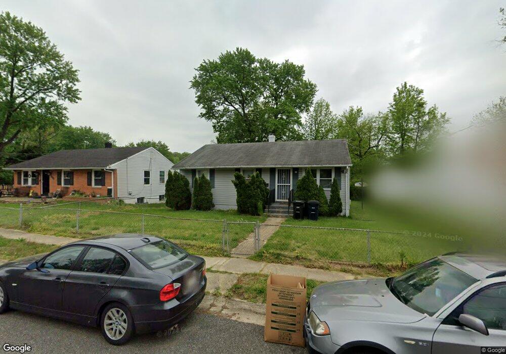
1109 Elkhart St Oxon Hill, MD 20745
Estimated Value: $326,836 - $373,000
--
Bed
2
Baths
936
Sq Ft
$370/Sq Ft
Est. Value
About This Home
This home is located at 1109 Elkhart St, Oxon Hill, MD 20745 and is currently estimated at $346,209, approximately $369 per square foot. 1109 Elkhart St is a home located in Prince George's County with nearby schools including Flintstone Elementary School, Oxon Hill Middle School, and Oxon Hill High School.
Ownership History
Date
Name
Owned For
Owner Type
Purchase Details
Closed on
Nov 12, 2003
Sold by
Green and L E
Bought by
Secretary Of H U D and Union Center Plaza Phase Ii
Current Estimated Value
Purchase Details
Closed on
Feb 8, 1995
Sold by
Roberts Anthony D
Bought by
Green Andre L
Home Financials for this Owner
Home Financials are based on the most recent Mortgage that was taken out on this home.
Original Mortgage
$111,500
Interest Rate
9.18%
Create a Home Valuation Report for This Property
The Home Valuation Report is an in-depth analysis detailing your home's value as well as a comparison with similar homes in the area
Home Values in the Area
Average Home Value in this Area
Purchase History
| Date | Buyer | Sale Price | Title Company |
|---|---|---|---|
| Secretary Of H U D | $124,000 | -- | |
| Green Andre L | $111,000 | -- |
Source: Public Records
Mortgage History
| Date | Status | Borrower | Loan Amount |
|---|---|---|---|
| Previous Owner | Green Andre L | $111,500 |
Source: Public Records
Tax History Compared to Growth
Tax History
| Year | Tax Paid | Tax Assessment Tax Assessment Total Assessment is a certain percentage of the fair market value that is determined by local assessors to be the total taxable value of land and additions on the property. | Land | Improvement |
|---|---|---|---|---|
| 2025 | $3,239 | $258,500 | -- | -- |
| 2024 | $3,239 | $244,400 | $75,300 | $169,100 |
| 2023 | $3,114 | $228,900 | $0 | $0 |
| 2022 | $2,963 | $213,400 | $0 | $0 |
| 2021 | $2,815 | $197,900 | $75,100 | $122,800 |
| 2020 | $2,746 | $186,667 | $0 | $0 |
| 2019 | $2,663 | $175,433 | $0 | $0 |
| 2018 | $2,567 | $164,200 | $75,100 | $89,100 |
| 2017 | $2,490 | $153,833 | $0 | $0 |
| 2016 | -- | $143,467 | $0 | $0 |
| 2015 | $2,742 | $133,100 | $0 | $0 |
| 2014 | $2,742 | $133,100 | $0 | $0 |
Source: Public Records
Map
Nearby Homes
- 7100 Southlawn Dr
- 1125 Devonshire Dr
- 735 Shelby Dr
- 6900 Stirling St
- 0 Livingston Rd
- 710 Leyte Place
- 7009 Shagbark Ct
- 554 Wilson Bridge Dr Unit 6755A( A2)
- 554 Wilson Bridge Dr Unit 6755 B-1
- 534 Wilson Bridge Dr Unit C-1
- 546 Wilson Bridge Dr Unit 6747C1
- 6903 Bock Rd
- 507 Wilson Bridge Dr Unit 6706A-2
- 505 Wilson Bridge Dr Unit 6704 C-2
- 1910 Belfast Dr
- 507 A-1 Wilson Bridge Dr Unit 6706 A-1
- 2004 Wolf St
- 6111A 1 Livingston Rd
- 557 Wilson Bridge Dr Unit C-1
- 302 Brockton Rd
- 1111 Elkhart St
- 1107 Elkhart St
- 1112 Lindsay Rd
- 1105 Elkhart St
- 1110 Lindsay Rd
- 1114 Lindsay Rd
- 6915 Jarrett Ave
- 1108 Lindsay Rd
- 1108 Elkhart St
- 1106 Elkhart St
- 1103 Elkhart St
- 1110 Elkhart St
- 1104 Elkhart St
- 1106 Lindsay Rd
- 1112 Elkhart St
- 1102 Elkhart St
- 1101 Elkhart St
- 1114 Elkhart St
- 1104 Lindsay Rd
- 1100 Elkhart St