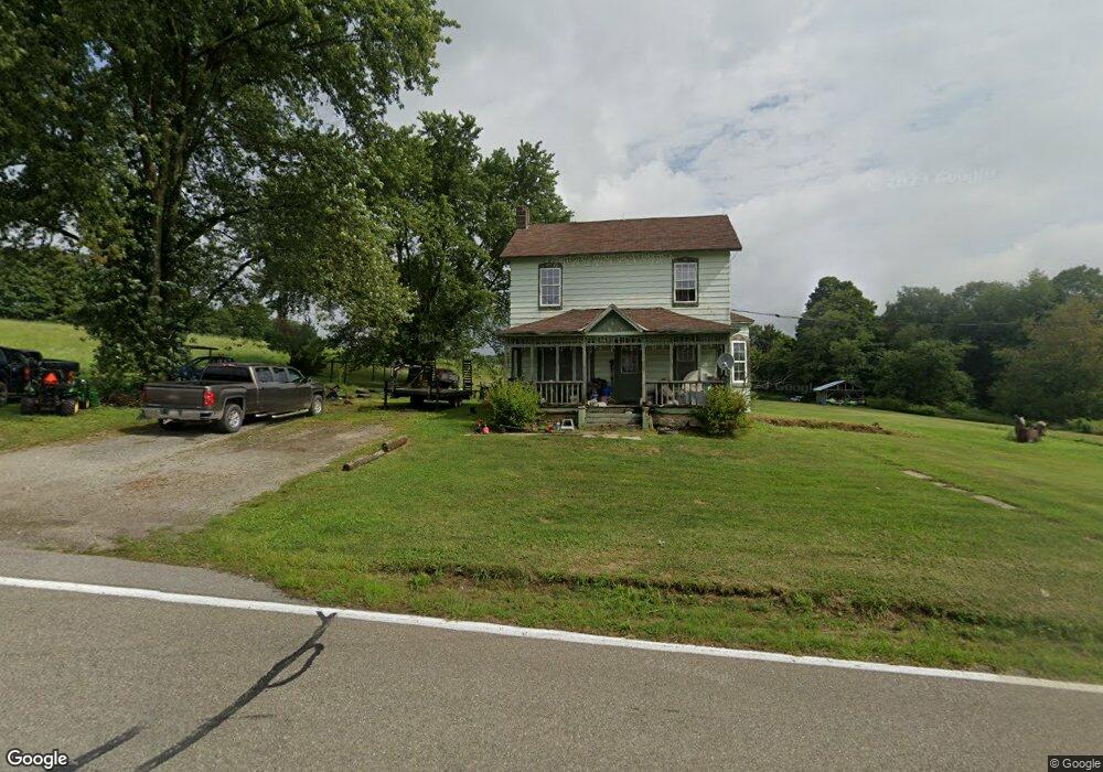
11091 Route 414 Roaring Branch, PA 17765
Estimated Value: $161,000 - $769,726
5
Beds
1
Bath
2,964
Sq Ft
$157/Sq Ft
Est. Value
About This Home
This home is located at 11091 Route 414, Roaring Branch, PA 17765 and is currently estimated at $465,363, approximately $157 per square foot. 11091 Route 414 is a home located in Tioga County with nearby schools including Liberty Elementary School and North Penn-Liberty Jr./Sr. High School.
Ownership History
Date
Name
Owned For
Owner Type
Purchase Details
Closed on
Dec 18, 2013
Sold by
Weller Shawn and Weller Annette C
Bought by
Remley Drew and Remley Lisa
Current Estimated Value
Home Financials for this Owner
Home Financials are based on the most recent Mortgage that was taken out on this home.
Original Mortgage
$105,600
Outstanding Balance
$78,698
Interest Rate
4.29%
Mortgage Type
Purchase Money Mortgage
Estimated Equity
$386,665
Purchase Details
Closed on
Aug 25, 2005
Sold by
Weller Shawn
Bought by
Weller Shawn and Weller Annette C
Home Financials for this Owner
Home Financials are based on the most recent Mortgage that was taken out on this home.
Original Mortgage
$94,200
Interest Rate
5.84%
Mortgage Type
Purchase Money Mortgage
Create a Home Valuation Report for This Property
The Home Valuation Report is an in-depth analysis detailing your home's value as well as a comparison with similar homes in the area
Home Values in the Area
Average Home Value in this Area
Purchase History
| Date | Buyer | Sale Price | Title Company |
|---|---|---|---|
| Remley Drew | $136,000 | None Available | |
| Weller Shawn | -- | None Available |
Source: Public Records
Mortgage History
| Date | Status | Borrower | Loan Amount |
|---|---|---|---|
| Open | Remley Drew | $105,600 | |
| Previous Owner | Weller Shawn | $94,200 |
Source: Public Records
Tax History Compared to Growth
Tax History
| Year | Tax Paid | Tax Assessment Tax Assessment Total Assessment is a certain percentage of the fair market value that is determined by local assessors to be the total taxable value of land and additions on the property. | Land | Improvement |
|---|---|---|---|---|
| 2025 | $8,707 | $620,280 | $29,440 | $590,840 |
| 2024 | $13,879 | $620,280 | $29,440 | $590,840 |
| 2023 | $8,523 | $330,610 | $8,450 | $322,160 |
| 2022 | $8,411 | $330,610 | $8,450 | $322,160 |
| 2021 | $8,292 | $330,610 | $8,450 | $322,160 |
| 2020 | $8,236 | $330,610 | $8,450 | $322,160 |
| 2019 | $14,823 | $330,610 | $8,450 | $322,160 |
| 2018 | $8,021 | $330,610 | $8,450 | $322,160 |
| 2017 | -- | $42,510 | $8,450 | $34,060 |
| 2016 | $999 | $63,860 | $29,800 | $34,060 |
| 2015 | -- | $42,510 | $8,450 | $34,060 |
| 2014 | -- | $56,210 | $8,450 | $47,760 |
Source: Public Records
Map
Nearby Homes
- 2537 Ogdensburg Rd
- 828 Bloss Mountain Rd
- 1177 Bloss Mountain Rd
- 1597 Beuterstown Rd
- 0 Taylor Run Rd
- 4489 Williamson Trail
- 47 E Hill St
- 68 Charles St
- 13632 Route 414
- 11068 Route 14 Hwy
- 221 S Williamson Rd
- 118 Main St
- 55 Main St
- 108 Tannery St
- 141 Main St
- 115 Granger St
- 159 Davis St
- 108 Mcintyre St
- 154 Main St
- 100 Log Row St
- 11170 Route 414
- 10983 Route 414
- 11215 Route 414
- 11216 State Route 414
- 11234 Route 414
- 36 Harer Rd
- 11255 Route 414
- 10954 Route 414
- 107 Harer Rd
- 58 Harer Rd
- 36 Taylor Run Rd
- 173 Taylor Run Rd
- 10793 Route 414
- 281 Harer Rd
- 11422 Route 414
- 1019 Bogar Run Rd
- 10778 Route 414
- 299 Taylor Run Rd
- 11434 Route 414
- 10855 Route 414