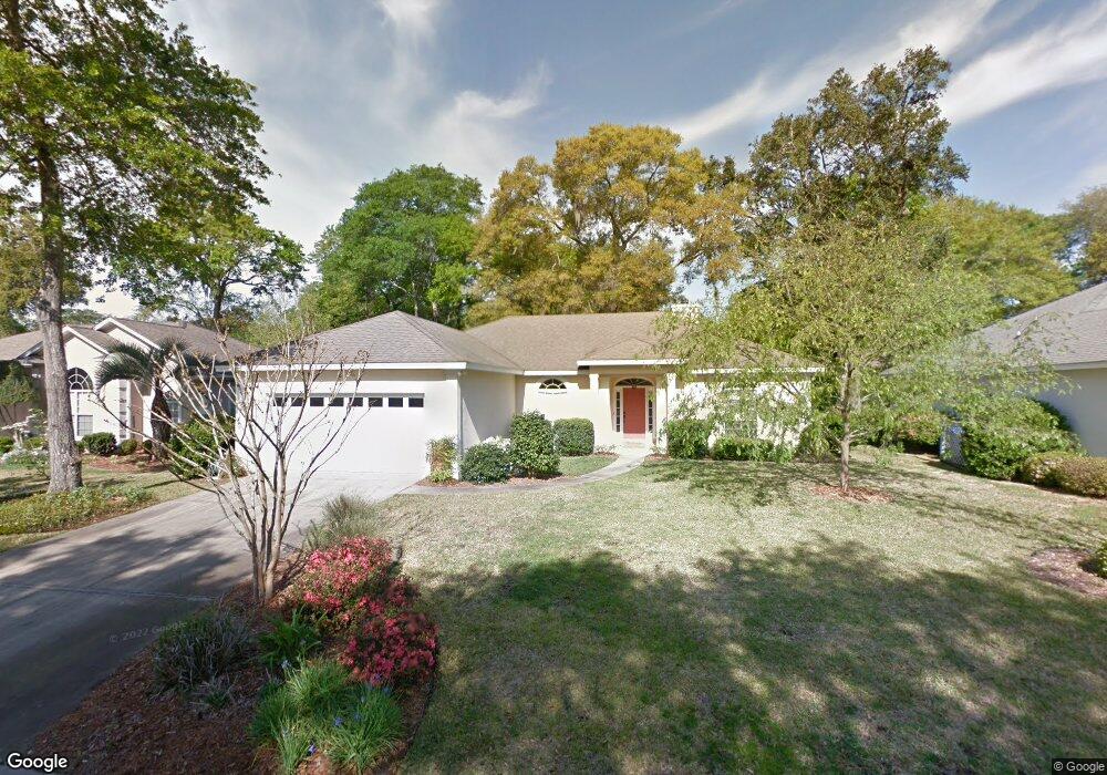
111 Ashwood Way Saint Simons Island, GA 31522
Estimated Value: $582,000 - $644,000
3
Beds
3
Baths
1,877
Sq Ft
$329/Sq Ft
Est. Value
About This Home
This home is located at 111 Ashwood Way, Saint Simons Island, GA 31522 and is currently estimated at $617,384, approximately $328 per square foot. 111 Ashwood Way is a home located in Glynn County with nearby schools including Oglethorpe Point Elementary School, Glynn Middle School, and Glynn Academy.
Ownership History
Date
Name
Owned For
Owner Type
Purchase Details
Closed on
Jul 28, 2006
Sold by
Everett Joe Ray
Bought by
Criss Julie A
Current Estimated Value
Home Financials for this Owner
Home Financials are based on the most recent Mortgage that was taken out on this home.
Original Mortgage
$225,000
Outstanding Balance
$134,240
Interest Rate
6.74%
Mortgage Type
New Conventional
Estimated Equity
$483,144
Create a Home Valuation Report for This Property
The Home Valuation Report is an in-depth analysis detailing your home's value as well as a comparison with similar homes in the area
Home Values in the Area
Average Home Value in this Area
Purchase History
| Date | Buyer | Sale Price | Title Company |
|---|---|---|---|
| Criss Julie A | $335,000 | -- |
Source: Public Records
Mortgage History
| Date | Status | Borrower | Loan Amount |
|---|---|---|---|
| Open | Criss Julie A | $225,000 | |
| Closed | Criss Julie A | $110,000 |
Source: Public Records
Tax History Compared to Growth
Tax History
| Year | Tax Paid | Tax Assessment Tax Assessment Total Assessment is a certain percentage of the fair market value that is determined by local assessors to be the total taxable value of land and additions on the property. | Land | Improvement |
|---|---|---|---|---|
| 2025 | $5,133 | $204,680 | $92,000 | $112,680 |
| 2024 | $5,149 | $205,320 | $92,000 | $113,320 |
| 2023 | $2,521 | $205,320 | $92,000 | $113,320 |
| 2022 | $2,961 | $170,680 | $80,000 | $90,680 |
| 2021 | $3,049 | $126,960 | $38,000 | $88,960 |
| 2020 | $3,076 | $126,960 | $38,000 | $88,960 |
| 2019 | $3,076 | $127,960 | $38,000 | $89,960 |
| 2018 | $2,943 | $112,960 | $38,000 | $74,960 |
| 2017 | $2,734 | $104,960 | $30,000 | $74,960 |
| 2016 | $2,533 | $104,960 | $30,000 | $74,960 |
| 2015 | $2,254 | $104,960 | $30,000 | $74,960 |
| 2014 | $2,254 | $92,960 | $30,000 | $62,960 |
Source: Public Records
Map
Nearby Homes
- 116 Ashwood Way
- 104 Ashwood Way
- 103 Travellers Way
- 129 Shadow Wood Bend
- 123 Shadow Wood Bend
- 131 Shadow Wood Bend
- 622 Brockinton Point
- 101 Barkentine Ct Unit A-1
- 306 Reserve Ln
- 222 Walmar Grove
- 109 Shady Brook Cir Unit 301
- 156 Shady Brook Cir Unit 101
- 112 Brookfield Trace
- 99 Brook Dr
- 117 Quamley Wells Dr
- 105 Brook Dr
- 150 Shady Brook Cir Unit 201
- 512 Brockinton S
- 102 Troon
- 361 Brockinton Marsh
- 113 Ashwood Way
- 109 Ashwood Way
- 113 Ashwood Way
- 110 Kingswood Ct
- 112 Kingswood Ct
- 110 Ashwood Way
- 110 Ashwood Way
- 108 Kingswood Ct
- 115 Ashwood Way
- 107 Ashwood Way
- 112 Ashwood Way
- 108 Ashwood Way
- 339 Brockinton Dr
- 331 Brockinton Dr
- 327 Brockinton Dr Unit 27
- 347 Brockinton Dr Unit 47
- 323 Brockinton Dr
- 317 Brockinton Dr
- 357 Brockinton Dr
- 359 Brockinton Dr