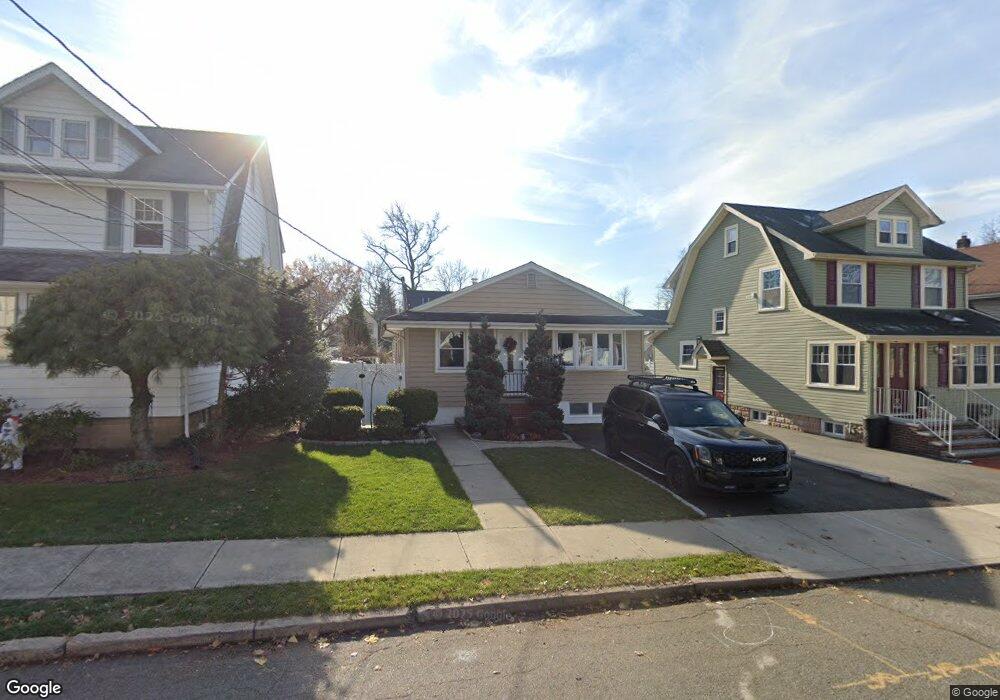
111 Davies Ave Dumont, NJ 07628
Estimated Value: $549,000 - $648,000
--
Bed
--
Bath
1,066
Sq Ft
$562/Sq Ft
Est. Value
About This Home
This home is located at 111 Davies Ave, Dumont, NJ 07628 and is currently estimated at $599,117, approximately $562 per square foot. 111 Davies Ave is a home located in Bergen County with nearby schools including Dumont High School.
Ownership History
Date
Name
Owned For
Owner Type
Purchase Details
Closed on
Aug 20, 2014
Sold by
Schiraldi Steven and Schiraldi Lori
Bought by
Morgan Jon R and Morgan Johanne
Current Estimated Value
Home Financials for this Owner
Home Financials are based on the most recent Mortgage that was taken out on this home.
Original Mortgage
$304,000
Outstanding Balance
$231,886
Interest Rate
4.12%
Mortgage Type
New Conventional
Estimated Equity
$367,231
Purchase Details
Closed on
Sep 4, 2009
Sold by
Calderone William J
Bought by
Schiraldi Steven and Schiraldi Lori
Home Financials for this Owner
Home Financials are based on the most recent Mortgage that was taken out on this home.
Original Mortgage
$299,475
Interest Rate
5.12%
Mortgage Type
Purchase Money Mortgage
Create a Home Valuation Report for This Property
The Home Valuation Report is an in-depth analysis detailing your home's value as well as a comparison with similar homes in the area
Home Values in the Area
Average Home Value in this Area
Purchase History
| Date | Buyer | Sale Price | Title Company |
|---|---|---|---|
| Morgan Jon R | $320,000 | -- | |
| Schiraldi Steven | $305,000 | -- |
Source: Public Records
Mortgage History
| Date | Status | Borrower | Loan Amount |
|---|---|---|---|
| Open | Morgan Jon R | $304,000 | |
| Previous Owner | Schiraldi Steven | $299,475 |
Source: Public Records
Tax History Compared to Growth
Tax History
| Year | Tax Paid | Tax Assessment Tax Assessment Total Assessment is a certain percentage of the fair market value that is determined by local assessors to be the total taxable value of land and additions on the property. | Land | Improvement |
|---|---|---|---|---|
| 2025 | $10,805 | $486,900 | $274,000 | $212,900 |
| 2024 | $10,539 | $265,800 | $145,000 | $120,800 |
| 2023 | $10,321 | $265,800 | $145,000 | $120,800 |
| 2022 | $10,321 | $265,800 | $145,000 | $120,800 |
| 2021 | $10,271 | $265,800 | $145,000 | $120,800 |
| 2020 | $9,991 | $265,800 | $145,000 | $120,800 |
| 2019 | $9,752 | $265,800 | $145,000 | $120,800 |
| 2018 | $9,158 | $254,800 | $145,000 | $109,800 |
| 2017 | $8,982 | $254,800 | $145,000 | $109,800 |
| 2016 | $8,773 | $254,800 | $145,000 | $109,800 |
| 2015 | $8,571 | $254,800 | $145,000 | $109,800 |
| 2014 | $8,403 | $254,800 | $145,000 | $109,800 |
Source: Public Records
Map
Nearby Homes