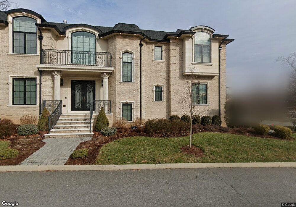
111 Demarest Ave Englewood Cliffs, NJ 07632
Estimated Value: $1,887,000 - $3,094,000
6
Beds
6
Baths
4,212
Sq Ft
$626/Sq Ft
Est. Value
About This Home
This home is located at 111 Demarest Ave, Englewood Cliffs, NJ 07632 and is currently estimated at $2,634,902, approximately $625 per square foot. 111 Demarest Ave is a home located in Bergen County with nearby schools including North Cliff Elementary School, Upper School Elementary School, and Dwight-Englewood School.
Ownership History
Date
Name
Owned For
Owner Type
Purchase Details
Closed on
Jan 31, 2002
Sold by
Desantis Therresa
Bought by
Civan Raffi and Civan Denise M
Current Estimated Value
Home Financials for this Owner
Home Financials are based on the most recent Mortgage that was taken out on this home.
Original Mortgage
$365,750
Interest Rate
6.91%
Create a Home Valuation Report for This Property
The Home Valuation Report is an in-depth analysis detailing your home's value as well as a comparison with similar homes in the area
Home Values in the Area
Average Home Value in this Area
Purchase History
| Date | Buyer | Sale Price | Title Company |
|---|---|---|---|
| Civan Raffi | $385,000 | -- |
Source: Public Records
Mortgage History
| Date | Status | Borrower | Loan Amount |
|---|---|---|---|
| Previous Owner | Civan Raffi | $365,750 |
Source: Public Records
Tax History Compared to Growth
Tax History
| Year | Tax Paid | Tax Assessment Tax Assessment Total Assessment is a certain percentage of the fair market value that is determined by local assessors to be the total taxable value of land and additions on the property. | Land | Improvement |
|---|---|---|---|---|
| 2025 | $24,917 | $2,157,300 | $837,200 | $1,320,100 |
| 2024 | $24,615 | $2,157,300 | $837,200 | $1,320,100 |
| 2023 | $24,226 | $2,157,300 | $837,200 | $1,320,100 |
| 2022 | $24,226 | $2,157,300 | $837,200 | $1,320,100 |
| 2021 | $18,624 | $2,157,300 | $837,200 | $1,320,100 |
| 2020 | $24,831 | $2,157,300 | $837,200 | $1,320,100 |
| 2019 | $23,320 | $2,157,300 | $837,200 | $1,320,100 |
| 2018 | $22,501 | $2,157,300 | $837,200 | $1,320,100 |
| 2017 | $8,355 | $837,200 | $837,200 | $0 |
| 2016 | $8,894 | $908,500 | $837,200 | $71,300 |
| 2015 | $8,449 | $908,500 | $837,200 | $71,300 |
| 2014 | $7,904 | $908,500 | $837,200 | $71,300 |
Source: Public Records
Map
Nearby Homes
- 560 Floyd St
- 564 Floyd St
- 108 Demarest Ave
- 566 Floyd St
- 554 Floyd St
- 113 Demarest Ave
- 563 Floyd St
- 55 Marjorie Terrace
- 100 Pershing Rd
- 550 Floyd St
- 571 Floyd St
- 557 Floyd St
- 108 Pershing Rd
- 115 Demarest Ave
- 56 Marjorie Terrace
- 110 Pershing Rd
- 23 Demarest Ave
- 544 Floyd St
- 20 Demarest Ave
- 573 Floyd St