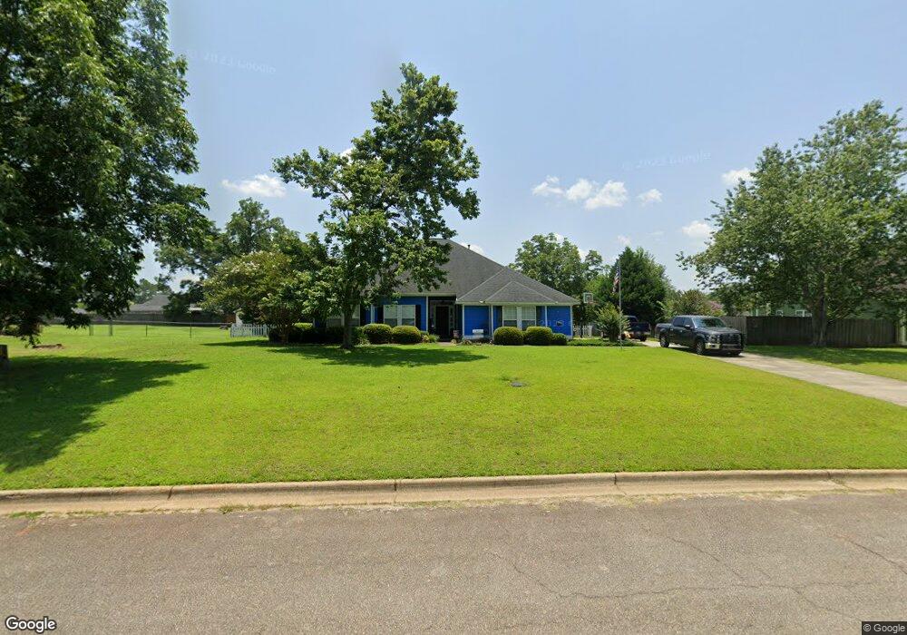
111 Hawkstead Dr Leesburg, GA 31763
Estimated Value: $254,697 - $290,000
3
Beds
2
Baths
1,672
Sq Ft
$161/Sq Ft
Est. Value
About This Home
This home is located at 111 Hawkstead Dr, Leesburg, GA 31763 and is currently estimated at $269,174, approximately $160 per square foot. 111 Hawkstead Dr is a home located in Lee County with nearby schools including Lee County Primary School, Lee County Elementary School, and Lee County Middle School - West Campus.
Ownership History
Date
Name
Owned For
Owner Type
Purchase Details
Closed on
Nov 1, 2001
Sold by
Brewer Daniel Joseph
Bought by
Brewer Daniel Joseph
Current Estimated Value
Purchase Details
Closed on
Sep 1, 2001
Sold by
T-D Services Inc
Bought by
The Marrick Co Inc
Purchase Details
Closed on
Sep 1, 1999
Sold by
Weckwert Inc
Bought by
T-D Services Inc
Purchase Details
Closed on
Jan 24, 1996
Sold by
Selective Enterprise
Bought by
Weckwert Inc
Create a Home Valuation Report for This Property
The Home Valuation Report is an in-depth analysis detailing your home's value as well as a comparison with similar homes in the area
Home Values in the Area
Average Home Value in this Area
Purchase History
| Date | Buyer | Sale Price | Title Company |
|---|---|---|---|
| Brewer Daniel Joseph | -- | -- | |
| Brewer Daniel Joseph | $132,500 | -- | |
| The Marrick Co Inc | $18,500 | -- | |
| T-D Services Inc | $89,400 | -- | |
| Weckwert Inc | $196,400 | -- |
Source: Public Records
Tax History
| Year | Tax Paid | Tax Assessment Tax Assessment Total Assessment is a certain percentage of the fair market value that is determined by local assessors to be the total taxable value of land and additions on the property. | Land | Improvement |
|---|---|---|---|---|
| 2025 | $2,768 | $95,916 | $8,000 | $87,916 |
| 2024 | $2,038 | $67,476 | $8,000 | $59,476 |
| 2023 | $1,901 | $67,476 | $8,000 | $59,476 |
| 2022 | $1,901 | $67,476 | $8,000 | $59,476 |
| 2021 | $1,905 | $67,476 | $8,000 | $59,476 |
| 2020 | $1,721 | $51,992 | $8,480 | $43,512 |
| 2019 | $1,752 | $51,992 | $8,480 | $43,512 |
| 2018 | $1,752 | $51,992 | $8,480 | $43,512 |
| 2017 | $1,659 | $51,992 | $8,480 | $43,512 |
| 2016 | $1,659 | $51,992 | $8,480 | $43,512 |
| 2015 | $1,669 | $51,992 | $8,480 | $43,512 |
| 2014 | $1,971 | $61,192 | $10,000 | $51,192 |
| 2013 | -- | $61,192 | $10,000 | $51,192 |
Source: Public Records
Map
Nearby Homes
- 164 Ambleside Dr
- 112 Beowulf Ln
- 107 Beowulf Ln
- 5004 Edith Dr
- 695 Winifred Rd
- 116 Barrondale Ct
- 136 Brompton Dr
- 109 Lambeth Ct
- 108 Lambeth Ct
- 285 Hawkstead Dr
- 112 Lambeth Ct
- 116 Lambeth Ct
- 389 Wiregrass Way
- 127 Shumard Ct
- 123 Larkspur Dr
- 227 Longleaf Dr
- 196 Winnstead Dr
- 193 Winnstead Dr
- 2621 Crofton Dr
- 134 Silver Leaf Dr
- 107 Hawkstead Dr
- 115 Hawkstead Dr
- 131 Ambleside Dr
- 103 Hawkstead Dr
- 108 Hawkstead Dr
- 143 Ambleside Dr
- 139 Ambleside Dr
- 125 Ambleside Dr
- 147 Ambleside Dr
- 112 Hawkstead Dr
- 116 Hawkstead Dr
- 121 Hawkstead Dr
- 121 Ambleside Dr
- 120 Hawkstead Dr
- 155 Ambleside Dr
- 104 Hawkstead Dr
- 101 Hawkstead Dr
- 127 Hawkstead Dr
- 124 Hawkstead Dr
- 117 Ambleside Dr
Your Personal Tour Guide
Ask me questions while you tour the home.