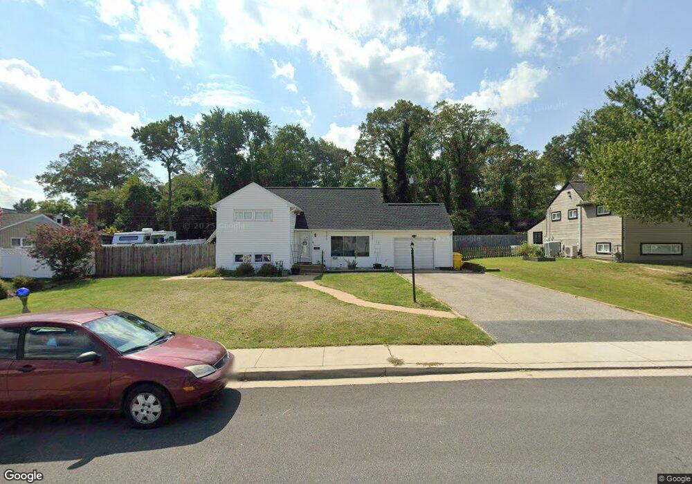
111 Jackpine Dr Pasadena, MD 21122
Riviera Beach NeighborhoodEstimated Value: $404,824 - $463,000
About This Home
This home is located at 111 Jackpine Dr, Pasadena, MD 21122 and is currently estimated at $437,206, approximately $291 per square foot. 111 Jackpine Dr is a home located in Anne Arundel County with nearby schools including Sunset Elementary School, Northeast Middle School, and Northeast High School.
Ownership History
We collect this data history from publicly available records. To have your information removed, we recommend requesting removal directly through your county’s website.
Purchase Details
Purchase Details
Purchase Details
Purchase Details
Home Financials for this Owner
Home Financials are based on the most recent Mortgage that was taken out on this home.Home Values in the Area
Average Home Value in this Area
Purchase History
We collect this data history from publicly available records. To have your information removed, we recommend requesting removal directly through your county’s website.
| Date | Buyer | Sale Price | Title Company |
|---|---|---|---|
| -- | None Listed On Document | ||
| -- | None Listed On Document | ||
| -- | Brillian Title Corporation | ||
| -- | -- | ||
| $120,000 | -- |
Mortgage History
We collect this data history from publicly available records. To have your information removed, we recommend requesting removal directly through your county’s website.
| Date | Status | Borrower | Loan Amount |
|---|---|---|---|
| Previous Owner | $102,000 |
Tax History
We collect this data history from publicly available records. To have your information removed, we recommend requesting removal directly through your county’s website.
| Year | Tax Paid | Tax Assessment Tax Assessment Total Assessment is a certain percentage of the fair market value that is determined by local assessors to be the total taxable value of land and additions on the property. | Land | Improvement |
|---|---|---|---|---|
| 2025 | $4,057 | $316,500 | -- | -- |
| 2024 | $4,057 | $310,000 | $183,900 | $126,100 |
| 2023 | $3,330 | $304,933 | $0 | $0 |
| 2022 | $3,724 | $299,867 | $0 | $0 |
| 2020 | $3,483 | $280,633 | $0 | $0 |
| 2019 | $3,720 | $266,467 | $0 | $0 |
| 2018 | $2,558 | $252,300 | $120,800 | $131,500 |
| 2017 | $2,883 | $237,467 | $0 | $0 |
| 2016 | -- | $222,633 | $0 | $0 |
| 2015 | -- | $207,800 | $0 | $0 |
| 2014 | -- | $206,767 | $0 | $0 |
Map
- 119 Sandy Beach Dr
- 8614 Black Rock Harbour
- 8560 Kim Marie Ct
- 8563 Chris Ct
- 7818 Renshaw Rd
- 8659 Scorton Harbour
- 1288 Holmespun Dr
- 40 Johnson Rd
- 1013 Cape Splitt Harbour
- 1219 Meadow View Rd
- 1016 Cape Splitt Harbour
- 1066 Saybrook Harbour
- 8692 Scorton Harbour
- 1312 Tuggies Rd
- 8700 Scorton Harbour
- 1262 Rock Hill Rd
- 1264 Rock Hill Rd
- 1010 Tennant Harbour
- 1202 Hillcreek Rd
- 7663 Sherlock Ct
Ask me questions while you tour the home.