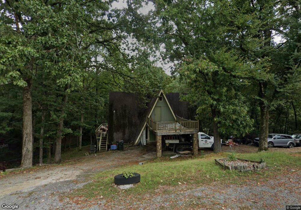
111 Makaha Point Hot Springs National Park, AR 71913
Estimated Value: $170,000 - $291,000
2
Beds
2
Baths
1,472
Sq Ft
$156/Sq Ft
Est. Value
About This Home
This home is located at 111 Makaha Point, Hot Springs National Park, AR 71913 and is currently estimated at $228,940, approximately $155 per square foot. 111 Makaha Point is a home located in Garland County with nearby schools including Malvern Elementary School, Wilson Intermediate School, and Malvern Junior High School.
Ownership History
Date
Name
Owned For
Owner Type
Purchase Details
Closed on
Jan 16, 2018
Sold by
Walls Kevin and Walls Kathryn
Bought by
Kimpton Daniel and Kimpton Karen
Current Estimated Value
Home Financials for this Owner
Home Financials are based on the most recent Mortgage that was taken out on this home.
Original Mortgage
$25,000
Outstanding Balance
$21,097
Interest Rate
3.94%
Mortgage Type
Future Advance Clause Open End Mortgage
Estimated Equity
$207,843
Purchase Details
Closed on
May 31, 2016
Sold by
Mckee Leon Wallace and Mckee Grandchildren Trust
Bought by
Osteen Peter D and Osteen Jodi Wileen Wofford
Home Financials for this Owner
Home Financials are based on the most recent Mortgage that was taken out on this home.
Original Mortgage
$132,554
Interest Rate
4.5%
Mortgage Type
FHA
Purchase Details
Closed on
Jan 1, 1901
Bought by
Mckee Bob W
Create a Home Valuation Report for This Property
The Home Valuation Report is an in-depth analysis detailing your home's value as well as a comparison with similar homes in the area
Home Values in the Area
Average Home Value in this Area
Purchase History
| Date | Buyer | Sale Price | Title Company |
|---|---|---|---|
| Kimpton Daniel | $25,000 | Hot Springs Title Co Inc | |
| Osteen Peter D | $135,000 | Garland County Title Co | |
| Mckee Bob W | -- | -- |
Source: Public Records
Mortgage History
| Date | Status | Borrower | Loan Amount |
|---|---|---|---|
| Open | Kimpton Daniel | $25,000 | |
| Previous Owner | Osteen Peter D | $132,554 | |
| Previous Owner | Mckee Bob W | $75,000 |
Source: Public Records
Tax History Compared to Growth
Tax History
| Year | Tax Paid | Tax Assessment Tax Assessment Total Assessment is a certain percentage of the fair market value that is determined by local assessors to be the total taxable value of land and additions on the property. | Land | Improvement |
|---|---|---|---|---|
| 2025 | $738 | $29,400 | $2,160 | $27,240 |
| 2024 | $820 | $29,400 | $2,160 | $27,240 |
| 2023 | $656 | $29,400 | $2,160 | $27,240 |
| 2022 | $1,083 | $29,400 | $2,160 | $27,240 |
| 2021 | $995 | $20,070 | $1,580 | $18,490 |
| 2020 | $995 | $20,070 | $1,580 | $18,490 |
| 2019 | $909 | $20,070 | $1,580 | $18,490 |
| 2018 | $995 | $20,070 | $1,580 | $18,490 |
| 2017 | $829 | $20,070 | $1,580 | $18,490 |
| 2016 | $793 | $19,200 | $1,580 | $17,620 |
| 2015 | $793 | $19,200 | $1,580 | $17,620 |
| 2014 | $792 | $19,200 | $1,580 | $17,620 |
Source: Public Records
Map
Nearby Homes
- 105 Flintwood Ct
- Lot 1092 Cedar Hill Dr
- 21 Springbrook Dr
- 249 Springbrook Dr
- 28 Edgemont Dr
- 28A Edgemont Dr
- Lot 859 Morningside Dr
- 343 Arlington Point
- 132 Victoria Ln
- Lot 1060 Hawaii Ct
- 1016 Arlington Point
- Lot 1132A Edgehill Ct
- lot 1152A Edgehill Ct
- lot 2993 Ivy Hill Ct
- 195 Windsong Bay Dr
- Lot 102 & 103 Marsh Harbor
- LOT 42 Windsong Bay Dr
- LOT 43 Windsong Bay Dr
- Lots 45&46 Windsong Bay Dr
- LOT 44 Windsong Bay Dr
- 110 Makaha Point
- 106 Makaha Point
- 102 Makaha Point
- 111 Flintwood Ct
- 116 Makaha Point
- 223 Springbrook Dr
- 100 Makaha Point
- 224 Springbrook Dr
- 100 Potomac
- 100 Potomac
- 0 Makaha Point Unit 17011919
- 224 Springbrook Dr
- 227 Springbrook Dr
- 231 Springbrook Dr
- 116 Cedar Hill Dr
- 232 Springbrook Dr
- 232 Springbrook Dr
- 233 Springbrook Dr
- 233 Springbrook Dr
- 117 Cedar Hill Dr