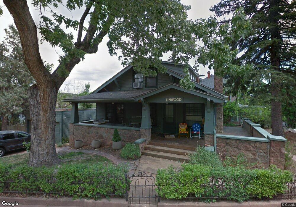
111 Mohawk St Manitou Springs, CO 80829
Estimated Value: $689,277 - $832,000
4
Beds
3
Baths
1,958
Sq Ft
$388/Sq Ft
Est. Value
About This Home
This home is located at 111 Mohawk St, Manitou Springs, CO 80829 and is currently estimated at $759,426, approximately $387 per square foot. 111 Mohawk St is a home located in El Paso County with nearby schools including Manitou Springs Elementary School, Manitou Springs Middle School, and Manitou Springs High School.
Ownership History
Date
Name
Owned For
Owner Type
Purchase Details
Closed on
Mar 16, 1998
Sold by
Flanagan Edward W and Flanagan Dena R
Bought by
American Christian College
Current Estimated Value
Purchase Details
Closed on
Jul 17, 1991
Bought by
American Christian College
Purchase Details
Closed on
Jan 30, 1990
Bought by
American Christian College
Purchase Details
Closed on
Jul 8, 1987
Bought by
American Christian College
Purchase Details
Closed on
Dec 1, 1983
Bought by
American Christian College
Create a Home Valuation Report for This Property
The Home Valuation Report is an in-depth analysis detailing your home's value as well as a comparison with similar homes in the area
Home Values in the Area
Average Home Value in this Area
Purchase History
| Date | Buyer | Sale Price | Title Company |
|---|---|---|---|
| American Christian College | $198,000 | -- | |
| American Christian College | $120,000 | -- | |
| American Christian College | $125,000 | -- | |
| American Christian College | -- | -- | |
| American Christian College | -- | -- |
Source: Public Records
Tax History Compared to Growth
Tax History
| Year | Tax Paid | Tax Assessment Tax Assessment Total Assessment is a certain percentage of the fair market value that is determined by local assessors to be the total taxable value of land and additions on the property. | Land | Improvement |
|---|---|---|---|---|
| 2025 | $2,425 | $41,200 | -- | -- |
| 2024 | $2,233 | $45,840 | $3,980 | $41,860 |
| 2022 | $2,163 | $29,260 | $3,000 | $26,260 |
| 2021 | $2,255 | $30,100 | $3,090 | $27,010 |
| 2020 | $2,468 | $31,380 | $3,220 | $28,160 |
| 2019 | $2,620 | $31,380 | $3,220 | $28,160 |
| 2018 | $2,517 | $28,600 | $2,500 | $26,100 |
| 2017 | $2,225 | $28,600 | $2,500 | $26,100 |
| 2016 | $2,187 | $28,100 | $2,510 | $25,590 |
| 2015 | $2,161 | $28,100 | $2,510 | $25,590 |
| 2014 | $1,918 | $26,510 | $2,220 | $24,290 |
Source: Public Records
Map
Nearby Homes
- 125 Ruxton Ave
- 151 Ruxton Ave
- 1107 Manitou Ave
- 153 Capitol Hill Ave
- 105 Pawnee Ave
- 1117 Manitou Ave
- 0 Charcas Rd Unit REC3377987
- 0 Charcas Rd Unit 1024513
- 128 Cave Ave
- 527 Canon Ave
- 529 Canon Ave
- 103 Deer Path Ave
- 0 Manitou Terrace
- 136 Cave Ave
- 206 Pine Ridge Ave
- 140 Cave Ave
- 210 Mesa Ave
- 34 Fountain Place
- 135 South Path
- LOTS 1-10 Peakview Blvd
- 910 Prospect Place
- 918 Prospect Place
- 919 Osage Ave
- 919 Prospect Place
- 924 Prospect Place
- 917 Prospect Place
- 102 Mohawk St
- 909 Osage Ave
- 906 Prospect Place
- 915 Prospect Place
- 911 Prospect Place
- 923 Prospect Place
- 106 Navajo Ave
- 102 Navajo Ave
- 907 Prospect Place
- 910 Osage Ave
- 950 Midland Ave
- 946 Midland Ave
- 901 Prospect Place
- 948 Midland Ave