Estimated Value: $282,444 - $493,000
2
Beds
1
Bath
938
Sq Ft
$416/Sq Ft
Est. Value
About This Home
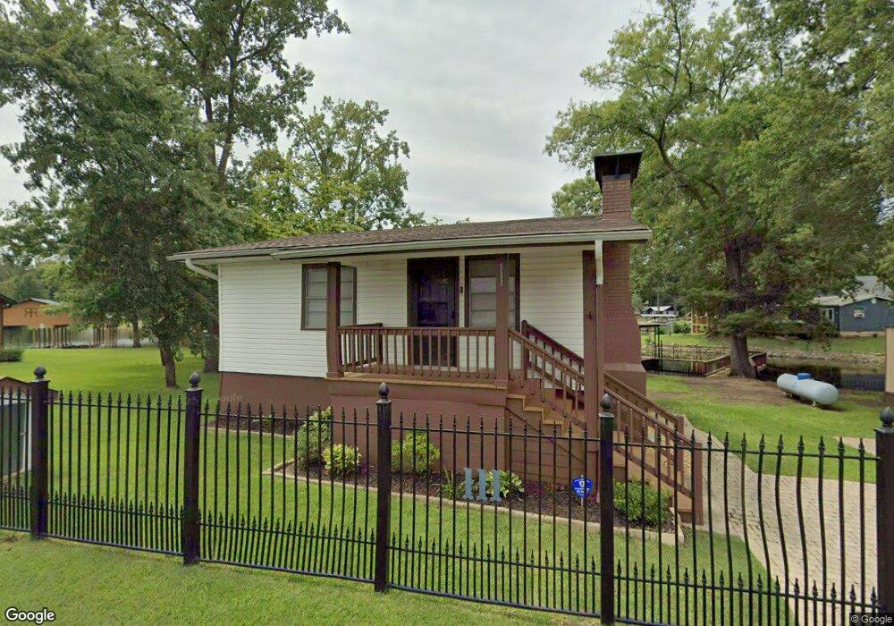
This home is located at 111 Muskogee Rd, Royal, AR 71968 and is currently estimated at $389,861, approximately $415 per square foot. 111 Muskogee Rd is a home located in Garland County with nearby schools including Lake Hamilton Primary School, Lake Hamilton Interm. School, and Lake Hamilton Elementary School.
Ownership History
Date
Name
Owned For
Owner Type
Purchase Details
Closed on
Feb 24, 2014
Sold by
Commissioner Of State Lands
Bought by
Isaacs James S and Isaacs Michael
Current Estimated Value
Purchase Details
Closed on
Aug 14, 2003
Sold by
Not Provided
Bought by
Hunter William H and Hunter Mary J
Purchase Details
Closed on
Mar 29, 1993
Sold by
Not Provided
Bought by
Mallon J P and Mallon Barbara J
Create a Home Valuation Report for This Property
The Home Valuation Report is an in-depth analysis detailing your home's value as well as a comparison with similar homes in the area
Home Values in the Area
Average Home Value in this Area
Purchase History
| Date | Buyer | Sale Price | Title Company |
|---|---|---|---|
| Isaacs James S | $1,780 | None Available | |
| Hunter William H | $117,000 | -- | |
| Mallon J P | -- | -- |
Source: Public Records
Tax History Compared to Growth
Tax History
| Year | Tax Paid | Tax Assessment Tax Assessment Total Assessment is a certain percentage of the fair market value that is determined by local assessors to be the total taxable value of land and additions on the property. | Land | Improvement |
|---|---|---|---|---|
| 2025 | $1,642 | $43,650 | $12,290 | $31,360 |
| 2024 | $1,504 | $43,650 | $12,290 | $31,360 |
| 2023 | $1,388 | $43,650 | $12,290 | $31,360 |
| 2022 | $1,342 | $43,650 | $12,290 | $31,360 |
| 2021 | $1,237 | $26,410 | $10,530 | $15,880 |
| 2020 | $1,237 | $26,410 | $10,530 | $15,880 |
| 2019 | $1,167 | $26,410 | $10,530 | $15,880 |
| 2018 | $1,167 | $26,410 | $10,530 | $15,880 |
| 2017 | $1,148 | $26,410 | $10,530 | $15,880 |
| 2016 | $1,032 | $23,350 | $10,530 | $12,820 |
| 2015 | $1,032 | $23,350 | $10,530 | $12,820 |
| 2014 | $1,032 | $23,350 | $10,530 | $12,820 |
Source: Public Records
Map
Nearby Homes
- 118 Muskogee Rd
- 168 Golden Oak Place
- 152 Muskogee Rd
- Lots 35 & 36 Maricopa Dr
- 156 Shady Oak Trail
- 136 Shady Oak Trail
- 0 Algonkin Dr
- 165 Tobacco Rd
- 105 Tall Oaks St
- 469 Treasure Isle Rd
- 111 Black Oak Ct
- 179 River Mill Ct Unit B2
- 179 River Mill Ct Unit D1
- 179 River Mill Ct Unit C1
- 179 River Mill C-1 Ct
- 179 River Mill D-1 Ct
- 179 River Mill B-2 Ct
- 0 River Mill Ct Unit 25041085
- 183 River Mill Ct Unit B-1
- 183 River Mill Ct Unit B-2
- 101 & 111 Muskogee
- 114 Muskogee Rd
- 101 Muskogee Rd
- 211 Iroquois Rd
- 126 Muskogee Rd
- 213 Iroquois Rd
- 136 Muskogee Rd
- 331 Iroquois Rd
- 140 Muskogee Rd
- 327 Iroquois Rd
- 325 Iroquois Rd
- 231 Iroquois Rd
- 161 Iroquois Rd
- 148 Muskogee Rd
- 224 Iroquois Rd
- 0 Muskogee Rd
- Land Iroquois Rd
- 317 Iroquois Rd
- 223 Tahoe Terrace
- 237 Iroquois Rd