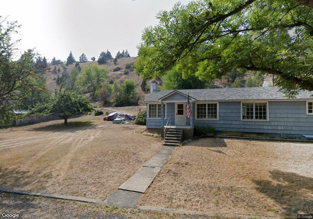
111 N Humbolt St Canyon City, OR 97820
Estimated Value: $318,000 - $328,302
3
Beds
2
Baths
1,436
Sq Ft
$225/Sq Ft
Est. Value
About This Home
This home is located at 111 N Humbolt St, Canyon City, OR 97820 and is currently estimated at $322,826, approximately $224 per square foot. 111 N Humbolt St is a home located in Grant County with nearby schools including Grant Union Junior/Senior High School.
Ownership History
Date
Name
Owned For
Owner Type
Purchase Details
Closed on
May 20, 2009
Sold by
Morgan Claude D and Morgan Deborah J
Bought by
Vandehey Daniel J and Vandehey Brandy
Current Estimated Value
Home Financials for this Owner
Home Financials are based on the most recent Mortgage that was taken out on this home.
Original Mortgage
$175,518
Outstanding Balance
$110,597
Interest Rate
4.8%
Mortgage Type
FHA
Estimated Equity
$212,229
Create a Home Valuation Report for This Property
The Home Valuation Report is an in-depth analysis detailing your home's value as well as a comparison with similar homes in the area
Home Values in the Area
Average Home Value in this Area
Purchase History
| Date | Buyer | Sale Price | Title Company |
|---|---|---|---|
| Vandehey Daniel J | $187,500 | None Available |
Source: Public Records
Mortgage History
| Date | Status | Borrower | Loan Amount |
|---|---|---|---|
| Open | Vandehey Daniel J | $175,518 |
Source: Public Records
Tax History Compared to Growth
Tax History
| Year | Tax Paid | Tax Assessment Tax Assessment Total Assessment is a certain percentage of the fair market value that is determined by local assessors to be the total taxable value of land and additions on the property. | Land | Improvement |
|---|---|---|---|---|
| 2024 | $2,640 | $167,897 | $22,928 | $144,969 |
| 2023 | $2,564 | $163,007 | $22,264 | $140,743 |
| 2022 | $2,489 | $158,260 | $21,613 | $136,647 |
| 2021 | $2,416 | $153,651 | $20,986 | $132,665 |
| 2020 | $2,522 | $149,176 | $20,369 | $128,807 |
| 2019 | $2,449 | $144,832 | $15,821 | $129,011 |
| 2018 | $2,746 | $140,614 | $15,362 | $125,252 |
| 2017 | $2,455 | $136,519 | $14,910 | $121,609 |
| 2016 | $2,395 | $132,543 | $14,568 | $117,975 |
| 2015 | $2,067 | $110,310 | $13,732 | $96,578 |
| 2014 | $2,067 | $110,310 | $13,732 | $96,578 |
| 2013 | $1,958 | $107,098 | $18,461 | $88,637 |
Source: Public Records
Map
Nearby Homes
- 2700 Elkview Dr
- 216 Elkview Dr
- 1500 Elk View Dr
- 2709 Elk View Dr
- 265 Elk View Dr
- 206 S Washington St
- 4008 Patterson Dr
- 4035 Patterson Dr
- 204 Adam Dr
- 107 Rebel Hill Rd
- 0 Adam Rd Unit 201410621
- 0 Adam Rd Unit 14393351
- 0 Elkview Dr Unit 22158071
- 0 Elkview Dr Unit 24255395
- 0 Elkview Dr Unit 195119069
- 0 Elkview Dr Unit 362870233
- 0 Elkview Dr Unit 24441871
- 217 Elkview Dr
- 26113 W Bench Rd
- 60408 Marysville Ln
- 115 N Humbolt St
- 109 N Humbolt St
- 125 N Humbolt St
- 119 N Clark St
- 115 N Clark St
- 127 N Humbolt St
- 103 N Humbolt St
- 31367 Clark Creek
- 107 N Clark St
- 122 N Clark St
- 120 N Clark St
- 129 N Humbolt St
- 24036 U S 395
- 116 N Clark St
- 124 Clark St
- 110 N Clark St
- 110 N Clark St
- 206 Elk View Dr
- 0 Elk View Dr
- 18736 Vester Creek Rd