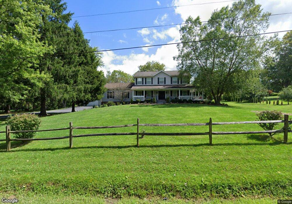
111 Sampson Dr Apollo, PA 15613
Washington Township NeighborhoodEstimated Value: $135,082 - $470,000
--
Bed
--
Bath
2,969
Sq Ft
$125/Sq Ft
Est. Value
About This Home
This home is located at 111 Sampson Dr, Apollo, PA 15613 and is currently estimated at $370,271, approximately $124 per square foot. 111 Sampson Dr is a home located in Westmoreland County with nearby schools including Kiski Area High School.
Ownership History
Date
Name
Owned For
Owner Type
Purchase Details
Closed on
Sep 12, 2005
Sold by
Euker Mark and Euker Danielle H
Bought by
Murphy Jason D and Murphy Angela K
Current Estimated Value
Home Financials for this Owner
Home Financials are based on the most recent Mortgage that was taken out on this home.
Original Mortgage
$168,000
Outstanding Balance
$90,276
Interest Rate
5.92%
Mortgage Type
Fannie Mae Freddie Mac
Estimated Equity
$279,995
Purchase Details
Closed on
Aug 13, 2002
Sold by
Sampson Doris P
Bought by
Euker Mark and Euker Danielle H
Home Financials for this Owner
Home Financials are based on the most recent Mortgage that was taken out on this home.
Original Mortgage
$138,000
Interest Rate
6.61%
Mortgage Type
Construction
Create a Home Valuation Report for This Property
The Home Valuation Report is an in-depth analysis detailing your home's value as well as a comparison with similar homes in the area
Home Values in the Area
Average Home Value in this Area
Purchase History
| Date | Buyer | Sale Price | Title Company |
|---|---|---|---|
| Murphy Jason D | $210,000 | -- | |
| Euker Mark | $30,000 | -- |
Source: Public Records
Mortgage History
| Date | Status | Borrower | Loan Amount |
|---|---|---|---|
| Open | Murphy Jason D | $168,000 | |
| Previous Owner | Euker Mark | $138,000 |
Source: Public Records
Tax History Compared to Growth
Tax History
| Year | Tax Paid | Tax Assessment Tax Assessment Total Assessment is a certain percentage of the fair market value that is determined by local assessors to be the total taxable value of land and additions on the property. | Land | Improvement |
|---|---|---|---|---|
| 2025 | $6,462 | $43,320 | $2,550 | $40,770 |
| 2024 | $6,126 | $43,320 | $2,550 | $40,770 |
| 2023 | $5,591 | $43,320 | $2,550 | $40,770 |
| 2022 | $5,419 | $43,320 | $2,550 | $40,770 |
| 2021 | $5,419 | $43,320 | $2,550 | $40,770 |
| 2020 | $5,405 | $43,320 | $2,550 | $40,770 |
| 2019 | $5,340 | $43,320 | $2,550 | $40,770 |
| 2018 | $5,253 | $37,400 | $2,550 | $34,850 |
| 2017 | $4,424 | $37,400 | $2,550 | $34,850 |
| 2016 | $4,153 | $34,980 | $2,550 | $32,430 |
| 2015 | $4,073 | $34,980 | $2,550 | $32,430 |
| 2014 | $4,051 | $34,980 | $2,550 | $32,430 |
Source: Public Records
Map
Nearby Homes
- 112 Siebert Ln
- Parcel A Beighley Rd
- 145 Shelby Ln
- 5306 Saddle Pack Trail
- 474 Exton Lake Rd
- 1749 Washington Rd
- 440 Chapeldale Dr
- 4306 Michel Ct
- 5553 Greensburg Rd
- 3513 Lashan Dr
- 830 Kiski Park Dr
- 3424 Lashan Dr
- 5924 Saltsburg Rd
- 835 Merwin Rd
- 4830 Dargate Ln
- Lot 1 Sardis Rd
- Lot 2 Sardis Rd
- 5150 Mamont Rd
- 4838 Sardis Rd
- 4941 Bulltown Rd