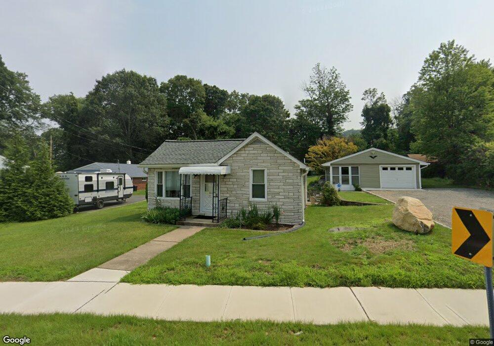
111 Shippenport Rd Landing, NJ 07850
Estimated Value: $320,794 - $431,000
--
Bed
--
Bath
832
Sq Ft
$446/Sq Ft
Est. Value
About This Home
This home is located at 111 Shippenport Rd, Landing, NJ 07850 and is currently estimated at $370,949, approximately $445 per square foot. 111 Shippenport Rd is a home located in Morris County with nearby schools including Eisenhower Middle School, Lincoln Roosevelt Elementary School, and Roxbury High School.
Ownership History
Date
Name
Owned For
Owner Type
Purchase Details
Closed on
Jan 23, 2023
Sold by
Garrison Paul Abram
Bought by
Garrison Paul Abram
Current Estimated Value
Purchase Details
Closed on
Jan 25, 2020
Sold by
Garrison Paul Abram and Garrison Patricia A
Bought by
Wellfleet Developers Inc
Purchase Details
Closed on
Jun 1, 2016
Sold by
107 Shippenport Road Land Trust
Bought by
Township Of Roxbury
Purchase Details
Closed on
May 21, 1998
Sold by
Garrison Paul Abram and Garrison Patricia A
Bought by
Garrison Paul Abram and Garrison Patricia A
Create a Home Valuation Report for This Property
The Home Valuation Report is an in-depth analysis detailing your home's value as well as a comparison with similar homes in the area
Home Values in the Area
Average Home Value in this Area
Purchase History
| Date | Buyer | Sale Price | Title Company |
|---|---|---|---|
| Garrison Paul Abram | -- | -- | |
| Wellfleet Developers Inc | $15,500 | None Available | |
| Township Of Roxbury | -- | None Available | |
| Garrison Paul Abram | -- | -- |
Source: Public Records
Tax History Compared to Growth
Tax History
| Year | Tax Paid | Tax Assessment Tax Assessment Total Assessment is a certain percentage of the fair market value that is determined by local assessors to be the total taxable value of land and additions on the property. | Land | Improvement |
|---|---|---|---|---|
| 2025 | $5,605 | $203,900 | $89,700 | $114,200 |
| 2024 | $5,518 | $203,900 | $89,700 | $114,200 |
| 2023 | $5,518 | $203,900 | $89,700 | $114,200 |
| 2022 | $4,604 | $205,500 | $91,300 | $114,200 |
| 2021 | $4,604 | $205,500 | $91,300 | $114,200 |
| 2020 | $5,384 | $204,800 | $90,600 | $114,200 |
| 2019 | $5,284 | $204,800 | $90,600 | $114,200 |
| 2018 | $5,267 | $122,200 | $68,600 | $53,600 |
| 2017 | $5,239 | $122,200 | $68,600 | $53,600 |
| 2016 | $5,136 | $122,200 | $68,600 | $53,600 |
| 2015 | $5,009 | $122,200 | $68,600 | $53,600 |
| 2014 | $4,930 | $122,200 | $68,600 | $53,600 |
Source: Public Records
Map
Nearby Homes
- Oakmont Grand Plan at Stone Water Village
- Roanoke Plan at Stone Water Village
- Powell Plan at Stone Water Village
- 2 Zachary Dr
- 90 Salmon Rd
- 33 Ford Rd Unit 35
- 16 Esposito Ln
- 168 Ledge-Landing
- 5 Zachary Dr
- 21 Laurie Rd
- 305 Kingsland Rd
- 181 Orben Dr
- 504 Ryerson Rd
- 512 Colver Rd
- 137 Lakeside Blvd
- 505 Logan Dr
- 537 Dell Rd
- 17 Frances Ave
- 66 Maple Ln
- 100 Zachary Way Unit 100
- 115 Shippenport Rd
- 107 Shippenport Rd
- 107 Shippenport Rd Unit B
- 124 Shippenport Rd
- 100 Mount Arlington Blvd
- 126 Shippenport Rd
- 99 Mount Arlington Blvd
- 1 Vail Rd
- 3 Amboy St
- 128 Shippenport Rd
- 101 Mount Arlington Blvd
- 3 Vail Rd
- 1 Zachary Dr Unit 37960791
- 1 Zachary Dr Unit 37421915
- 1 Zachary Dr Unit 37292430
- 1 Zachary Dr Unit 37233338
- 5 Vail Rd
- 2 Vail Rd
- 1 Ford Rd
- 105 Mount Arlington Blvd