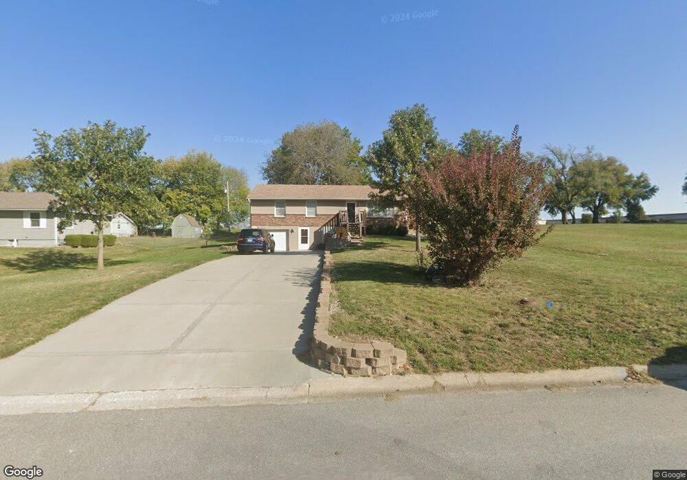
111 Spring St Pleasant Hill, MO 64080
Estimated Value: $241,211 - $271,000
3
Beds
2
Baths
1,196
Sq Ft
$215/Sq Ft
Est. Value
About This Home
This home is located at 111 Spring St, Pleasant Hill, MO 64080 and is currently estimated at $257,053, approximately $214 per square foot. 111 Spring St is a home located in Cass County with nearby schools including Pleasant Hill Primary School, Pleasant Hill Elementary School, and Pleasant Hill Middle School.
Ownership History
Date
Name
Owned For
Owner Type
Purchase Details
Closed on
Dec 16, 2016
Sold by
Thomson Eric B and Broockerd Mary Elizabeth
Bought by
Nelson Annie M
Current Estimated Value
Home Financials for this Owner
Home Financials are based on the most recent Mortgage that was taken out on this home.
Original Mortgage
$225,000
Outstanding Balance
$180,526
Interest Rate
3.57%
Mortgage Type
VA
Estimated Equity
$76,527
Create a Home Valuation Report for This Property
The Home Valuation Report is an in-depth analysis detailing your home's value as well as a comparison with similar homes in the area
Home Values in the Area
Average Home Value in this Area
Purchase History
| Date | Buyer | Sale Price | Title Company |
|---|---|---|---|
| Nelson Annie M | -- | Kansas City Title Inc |
Source: Public Records
Mortgage History
| Date | Status | Borrower | Loan Amount |
|---|---|---|---|
| Open | Nelson Annie M | $225,000 |
Source: Public Records
Tax History
| Year | Tax Paid | Tax Assessment Tax Assessment Total Assessment is a certain percentage of the fair market value that is determined by local assessors to be the total taxable value of land and additions on the property. | Land | Improvement |
|---|---|---|---|---|
| 2025 | $1,984 | $31,720 | $4,470 | $27,250 |
| 2024 | $1,984 | $27,710 | $4,070 | $23,640 |
| 2023 | $1,984 | $27,710 | $4,070 | $23,640 |
| 2022 | $1,801 | $24,680 | $4,070 | $20,610 |
| 2021 | $1,751 | $24,680 | $4,070 | $20,610 |
| 2020 | $1,655 | $23,880 | $4,070 | $19,810 |
| 2019 | $1,543 | $22,580 | $4,070 | $18,510 |
| 2018 | $1,380 | $19,910 | $3,250 | $16,660 |
| 2017 | $1,324 | $19,910 | $3,250 | $16,660 |
| 2016 | $1,324 | $19,030 | $3,250 | $15,780 |
| 2015 | $1,341 | $19,030 | $3,250 | $15,780 |
| 2014 | $1,346 | $19,030 | $3,250 | $15,780 |
| 2013 | -- | $19,030 | $3,250 | $15,780 |
Source: Public Records
Map
Nearby Homes
- 204 Lexington Rd
- 1408 Country Club Dr
- 0 Route 7
- 1314 Lawndale Ave
- 1307 Lawndale Ave
- 302 Cline St
- 501 Lexington Rd
- 1316 Delaware St
- 914 Locust St
- 1310 Baltimore St
- 1308 Baltimore St
- 810 Pine St
- 712 Locust St
- 0 Locust St
- 213 Sitter St
- 201 Sitter St
- 110 S Campbell St
- 1403 Red Bud Ave
- 1201 Maple Ln
- 812 Riffle Dr
- 109 Spring St
- 107 Spring St
- 105 Spring St
- 1519 Broadway St
- 209 Chris Dr
- 103 Spring St
- 200 Chappell Dr
- 202 Chappell Dr
- 101 Spring St
- 204 Chappell Dr
- 108 S Walker St
- 102 Spring St
- 106 S Walker St
- 201 Palmer Ct Unit 203
- 201 Palmer Ct
- 1402 Eagle Dr
- 206 Chappell Dr
- 201 Chappell Dr
- 1406 Eagle Dr
- 104 S Walker St
Your Personal Tour Guide
Ask me questions while you tour the home.