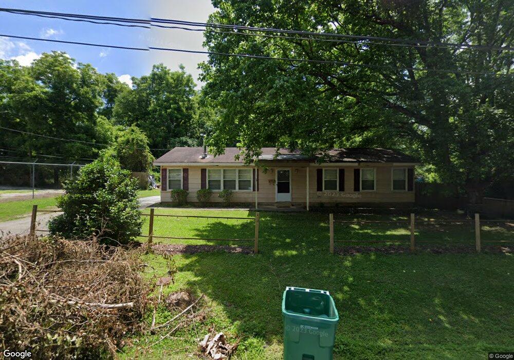
111 Witcher St Union Point, GA 30669
Estimated Value: $69,000 - $210,000
3
Beds
2
Baths
1,600
Sq Ft
$91/Sq Ft
Est. Value
About This Home
This home is located at 111 Witcher St, Union Point, GA 30669 and is currently estimated at $146,244, approximately $91 per square foot. 111 Witcher St is a home located in Greene County with nearby schools including Greene County High School.
Ownership History
Date
Name
Owned For
Owner Type
Purchase Details
Closed on
Mar 23, 1998
Sold by
Lindsey James and Lindsey Brenda M
Bought by
Lindsey James R
Current Estimated Value
Purchase Details
Closed on
Oct 31, 1986
Sold by
Lindsey James R and Lindsey Brenda
Bought by
Lindsey James and Lindsey Brenda M
Purchase Details
Closed on
Jan 1, 1986
Sold by
Fha
Bought by
Lindsey James R and Lindsey Brenda
Purchase Details
Closed on
Jan 1, 1977
Sold by
Wilson William R
Bought by
Daniel Robert F and Daniel Emma F
Purchase Details
Closed on
Jan 1, 1967
Bought by
Union Mfg Co
Create a Home Valuation Report for This Property
The Home Valuation Report is an in-depth analysis detailing your home's value as well as a comparison with similar homes in the area
Purchase History
| Date | Buyer | Sale Price | Title Company |
|---|---|---|---|
| Lindsey James R | -- | -- | |
| Lindsey James | -- | -- | |
| Lindsey James R | -- | -- | |
| Fha | -- | -- | |
| Daniel Robert F | -- | -- | |
| Wilson William R | -- | -- | |
| Union Mfg Co | -- | -- |
Source: Public Records
Tax History
| Year | Tax Paid | Tax Assessment Tax Assessment Total Assessment is a certain percentage of the fair market value that is determined by local assessors to be the total taxable value of land and additions on the property. | Land | Improvement |
|---|---|---|---|---|
| 2025 | $568 | $20,824 | $3,160 | $17,664 |
| 2024 | $551 | $19,624 | $3,160 | $16,464 |
| 2023 | $246 | $19,640 | $3,160 | $16,480 |
| 2022 | $369 | $17,832 | $3,160 | $14,672 |
| 2021 | $374 | $16,192 | $3,160 | $13,032 |
| 2020 | $320 | $9,640 | $2,680 | $6,960 |
| 2019 | $326 | $9,640 | $2,680 | $6,960 |
| 2018 | $187 | $9,640 | $2,680 | $6,960 |
| 2017 | $290 | $9,675 | $2,700 | $6,975 |
| 2016 | $304 | $10,233 | $2,700 | $7,533 |
| 2015 | $275 | $10,233 | $2,700 | $7,533 |
| 2014 | $283 | $10,422 | $2,700 | $7,722 |
Source: Public Records
Map
Nearby Homes
- 509 Carlton Ave
- 202 Veazey St
- 405 Crawfordville Rd
- 0 Woodland Ct Unit 10543600
- 324 N Rhodes St
- 1160 Moody St
- 215 Hunter St
- 1241 Old Siloam Rd
- 1071 Alexander St
- 000 Washington Hwy
- 0 Washington Hwy Unit 10686255
- 5401 Union Point Hwy
- 1581 Highway 77 S Hwy
- 1581 Highway 77 S
- 1201 Buffalo Lick Rd
- 0 Buffalo Lick Rd Unit 10551234
- 0 Buffalo Lick Rd Unit 10551325
- 1251 Adams Rd
- 1251 Brick House Rd
- 1251 Brickhouse Rd
Your Personal Tour Guide
Ask me questions while you tour the home.