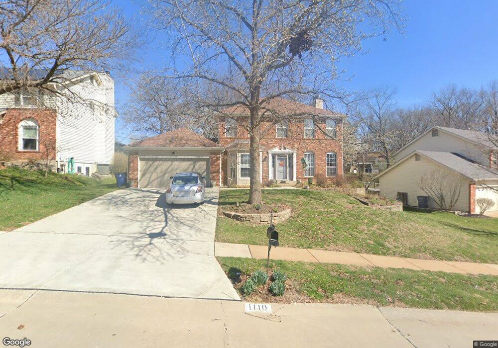
1110 Dunston Dr Saint Louis, MO 63146
Estimated Value: $395,090 - $512,000
4
Beds
3
Baths
1,980
Sq Ft
$230/Sq Ft
Est. Value
About This Home
This home is located at 1110 Dunston Dr, Saint Louis, MO 63146 and is currently estimated at $455,273, approximately $229 per square foot. 1110 Dunston Dr is a home located in St. Louis County with nearby schools including Willow Brook Elementary School, Pattonville Heights Middle School, and Pattonville High School.
Ownership History
Date
Name
Owned For
Owner Type
Purchase Details
Closed on
Aug 17, 2001
Sold by
Haudrich John A and Haudrich Wendy S
Bought by
Mctique Martin G and Mctique Catherine M
Current Estimated Value
Home Financials for this Owner
Home Financials are based on the most recent Mortgage that was taken out on this home.
Original Mortgage
$192,000
Interest Rate
7.16%
Purchase Details
Closed on
Jun 16, 1998
Sold by
Barrett Timothy R and Barrett Margaret B
Bought by
Haudrich John A and Haudrich Wendy S
Home Financials for this Owner
Home Financials are based on the most recent Mortgage that was taken out on this home.
Original Mortgage
$150,000
Interest Rate
7.17%
Create a Home Valuation Report for This Property
The Home Valuation Report is an in-depth analysis detailing your home's value as well as a comparison with similar homes in the area
Home Values in the Area
Average Home Value in this Area
Purchase History
| Date | Buyer | Sale Price | Title Company |
|---|---|---|---|
| Mctique Martin G | $240,000 | -- | |
| Haudrich John A | -- | -- |
Source: Public Records
Mortgage History
| Date | Status | Borrower | Loan Amount |
|---|---|---|---|
| Previous Owner | Mctique Martin G | $192,000 | |
| Previous Owner | Haudrich John A | $150,000 |
Source: Public Records
Tax History Compared to Growth
Tax History
| Year | Tax Paid | Tax Assessment Tax Assessment Total Assessment is a certain percentage of the fair market value that is determined by local assessors to be the total taxable value of land and additions on the property. | Land | Improvement |
|---|---|---|---|---|
| 2025 | $4,375 | $65,820 | $12,560 | $53,260 |
| 2024 | $4,375 | $62,470 | $6,690 | $55,780 |
| 2023 | $4,391 | $62,470 | $6,690 | $55,780 |
| 2022 | $4,131 | $53,480 | $10,050 | $43,430 |
| 2021 | $4,108 | $53,480 | $10,050 | $43,430 |
| 2020 | $4,084 | $51,050 | $10,050 | $41,000 |
| 2019 | $4,058 | $51,050 | $10,050 | $41,000 |
| 2018 | $4,065 | $46,890 | $10,050 | $36,840 |
| 2017 | $4,075 | $46,890 | $10,050 | $36,840 |
| 2016 | $4,470 | $50,500 | $11,700 | $38,800 |
| 2015 | $4,403 | $50,500 | $11,700 | $38,800 |
| 2014 | -- | $47,330 | $9,480 | $37,850 |
Source: Public Records
Map
Nearby Homes
- 50 Willow Brook Dr
- 1060 Port Diane Dr
- 1054 Willow Brook Dr
- 1033 Wilton Royal Dr Unit 210
- 1033 Wilton Royal Dr Unit 107
- 1033 Wilton Royal Dr Unit 204
- 10401 Briarbend Dr Unit 2
- 10469 Briarbend Dr Unit 3
- 1279 Guelbreth Ln Unit 210
- 10387 Forest Brook Ln
- 1251 Guelbreth Ln Unit 308
- 10352 Forest Brook Ln Unit H
- 10381 Oxford Hill Dr Unit 24
- 10381 Oxford Hill Dr Unit 14
- 10381 Oxford Hill Dr Unit 6
- 10344 Forest Brook Ln Unit C
- 10367 Oxford Hill Dr Unit 14
- 10367 Oxford Hill Dr Unit 6
- 10367 Oxford Hill Dr Unit 26
- 10340 Corbeil Dr Unit 86
- 1114 Dunston Dr
- 1106 Dunston Dr
- 1118 Dunston Dr
- 27 Deerfield Ct
- 29 Deerfield Ln
- 30 Fernwood Ln
- 1107 Dunston Dr
- 1102 Dunston Dr
- 1111 Dunston Dr
- 1122 Dunston Dr
- 11111 Apache Trail
- 28 Deerfield Ct
- 11100 Apache Trail
- 1117 Dunston Dr
- 11106 Apache Trail
- 26 Deerfield Ct
- 1126 Dunston Dr
- 31 Fernwood Ln
- 11117 Apache Trail
- 1121 Dunston Dr