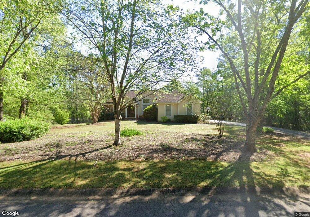
1110 Harrowford Rd N Statham, GA 30666
Estimated Value: $453,000 - $489,273
4
Beds
3
Baths
2,187
Sq Ft
$216/Sq Ft
Est. Value
About This Home
This home is located at 1110 Harrowford Rd N, Statham, GA 30666 and is currently estimated at $472,318, approximately $215 per square foot. 1110 Harrowford Rd N is a home located in Oconee County with nearby schools including Rocky Branch Elementary School, Malcom Bridge Middle School, and North Oconee High School.
Ownership History
Date
Name
Owned For
Owner Type
Purchase Details
Closed on
Dec 29, 2017
Sold by
Bearden Selby A
Bought by
Newton Cody A and Towery Katherine L
Current Estimated Value
Home Financials for this Owner
Home Financials are based on the most recent Mortgage that was taken out on this home.
Original Mortgage
$204,250
Outstanding Balance
$172,186
Interest Rate
3.9%
Mortgage Type
New Conventional
Estimated Equity
$300,132
Purchase Details
Closed on
Jul 15, 1994
Bought by
Bearden Selby Ajr
Purchase Details
Closed on
Apr 1, 1994
Bought by
Gonterman Robbie
Create a Home Valuation Report for This Property
The Home Valuation Report is an in-depth analysis detailing your home's value as well as a comparison with similar homes in the area
Home Values in the Area
Average Home Value in this Area
Purchase History
| Date | Buyer | Sale Price | Title Company |
|---|---|---|---|
| Newton Cody A | $215,000 | -- | |
| Bearden Selby Ajr | $130,000 | -- | |
| Gonterman Robbie | $14,500 | -- |
Source: Public Records
Mortgage History
| Date | Status | Borrower | Loan Amount |
|---|---|---|---|
| Open | Newton Cody A | $204,250 |
Source: Public Records
Tax History Compared to Growth
Tax History
| Year | Tax Paid | Tax Assessment Tax Assessment Total Assessment is a certain percentage of the fair market value that is determined by local assessors to be the total taxable value of land and additions on the property. | Land | Improvement |
|---|---|---|---|---|
| 2024 | $3,081 | $163,183 | $30,000 | $133,183 |
| 2023 | $3,081 | $149,280 | $22,000 | $127,280 |
| 2022 | $2,941 | $135,602 | $22,000 | $113,602 |
| 2021 | $2,521 | $107,532 | $22,000 | $85,532 |
| 2020 | $2,188 | $93,003 | $18,000 | $75,003 |
| 2019 | $2,187 | $92,954 | $18,000 | $74,954 |
| 2018 | $2,069 | $88,136 | $18,000 | $70,136 |
| 2017 | $1,823 | $77,606 | $18,000 | $59,606 |
| 2016 | $1,820 | $77,511 | $18,000 | $59,511 |
| 2015 | $1,832 | $77,896 | $18,000 | $59,896 |
| 2014 | $1,683 | $70,010 | $18,000 | $52,010 |
| 2013 | -- | $68,794 | $18,000 | $50,794 |
Source: Public Records
Map
Nearby Homes
- LOT 10 Sikes Rd
- LOT 9 Sikes Rd
- LOT 8 Sikes Rd
- LOT 7 Sikes Rd
- LOT 6 Sikes Rd
- LOT 5 Sikes Rd
- LOT 4 Sikes Rd
- LOT 3 Sikes Rd
- LOT 2 Sikes Rd
- LOT 1 Sikes Rd
- 1080 Ashland Dr
- 1471 Sikes Rd
- 1296 Club Estates Rd
- 2492 Rambling Rill Dr
- N/A Hog Mountain Rd
- 1901 Hog Mountain Rd
- 1921 Hog Mountain Rd
- 2986 Coralbell Dr
- 4611 Monroe Hwy - Hwy 78
- 4611 Monroe Hwy - Hwy 78 Unit PARCEL C
- 1110 Harrowford Dr N
- 1090 Harrowford Rd N
- 1130 Harrowford Dr N
- 1130 Harrowford Rd N
- 1111 Harrowford Rd N
- 1131 Harrowford Rd N
- 1140 Harrowford Dr N
- 1140 Harrowford Rd N
- 1020 Richards Ct
- 1141 Harrowford Dr N
- 0 Harrowford Dr N Unit 7247486
- 0 Harrowford Dr N Unit 3223267
- 0 Harrowford Dr N Unit 8723230
- 0 Harrowford Dr N Unit 7632056
- 1141 Harrowford Rd N
- 1091 Harrowford Dr N
- 1091 Harrowford Rd N
- N Harrowford Dr N
- 1071 Harrowford Rd N
- 1061 Harrowford Dr N