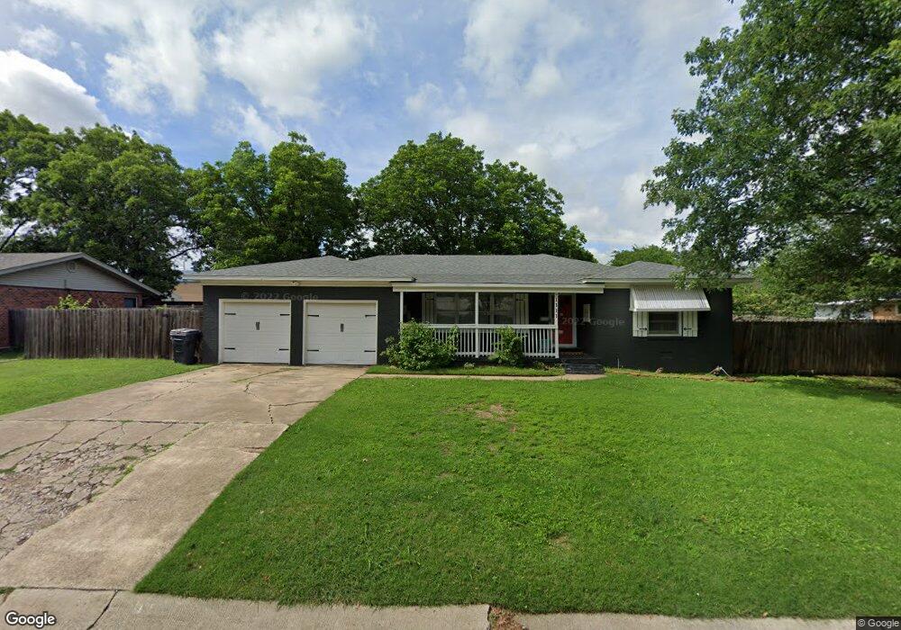
1111 Circle Dr Ardmore, OK 73401
Estimated Value: $145,000 - $171,000
3
Beds
2
Baths
1,492
Sq Ft
$109/Sq Ft
Est. Value
About This Home
This home is located at 1111 Circle Dr, Ardmore, OK 73401 and is currently estimated at $162,111, approximately $108 per square foot. 1111 Circle Dr is a home located in Carter County with nearby schools including Charles Evans Elementary School, Ardmore Middle School, and Ardmore High School.
Ownership History
Date
Name
Owned For
Owner Type
Purchase Details
Closed on
Feb 15, 2019
Sold by
Rudd Andy and Rudd Jami
Bought by
Job3e Sean L and Jobe Joy
Current Estimated Value
Home Financials for this Owner
Home Financials are based on the most recent Mortgage that was taken out on this home.
Original Mortgage
$108,363
Outstanding Balance
$96,529
Interest Rate
5.37%
Mortgage Type
FHA
Estimated Equity
$65,582
Purchase Details
Closed on
Jan 24, 2008
Sold by
Hunter Pat
Bought by
Rudd Andy and Rudd Jami
Home Financials for this Owner
Home Financials are based on the most recent Mortgage that was taken out on this home.
Original Mortgage
$100,000
Interest Rate
6.15%
Mortgage Type
New Conventional
Purchase Details
Closed on
Aug 30, 2002
Sold by
Hunter Edith F
Bought by
Hunter Pat
Purchase Details
Closed on
Oct 17, 1994
Sold by
Beauford Arthur R and Beauford D
Bought by
Warrington Margaret
Purchase Details
Closed on
Oct 13, 1994
Sold by
Mcdonald Sherry K and Mcdonald C
Bought by
Warrington Margaret
Create a Home Valuation Report for This Property
The Home Valuation Report is an in-depth analysis detailing your home's value as well as a comparison with similar homes in the area
Home Values in the Area
Average Home Value in this Area
Purchase History
| Date | Buyer | Sale Price | Title Company |
|---|---|---|---|
| Job3e Sean L | $114,000 | Stewart Title Of Oklahoma In | |
| Rudd Andy | $100,000 | -- | |
| Hunter Pat | $65,000 | -- | |
| Warrington Margaret | $18,500 | -- | |
| Warrington Margaret | $18,500 | -- |
Source: Public Records
Mortgage History
| Date | Status | Borrower | Loan Amount |
|---|---|---|---|
| Open | Job3e Sean L | $108,363 | |
| Previous Owner | Rudd Andy | $100,000 |
Source: Public Records
Tax History Compared to Growth
Tax History
| Year | Tax Paid | Tax Assessment Tax Assessment Total Assessment is a certain percentage of the fair market value that is determined by local assessors to be the total taxable value of land and additions on the property. | Land | Improvement |
|---|---|---|---|---|
| 2025 | $1,494 | $14,961 | $2,400 | $12,561 |
| 2024 | $1,494 | $15,589 | $2,400 | $13,189 |
| 2023 | $1,556 | $14,847 | $2,400 | $12,447 |
| 2022 | $1,352 | $14,140 | $2,400 | $11,740 |
| 2021 | $1,359 | $13,467 | $2,400 | $11,067 |
| 2020 | $1,360 | $13,680 | $1,368 | $12,312 |
| 2019 | $1,040 | $10,707 | $1,914 | $8,793 |
| 2018 | $1,007 | $10,198 | $1,001 | $9,197 |
| 2017 | $888 | $9,711 | $970 | $8,741 |
| 2016 | $862 | $9,248 | $357 | $8,891 |
| 2015 | $700 | $9,115 | $357 | $8,758 |
| 2014 | $777 | $8,681 | $357 | $8,324 |
Source: Public Records
Map
Nearby Homes
- 1496 US Highway 77
- 923 Maxwell St NW
- 912 Elm St
- 1907 Robison St
- 912 Maxwell St NW
- 1620 Shenandoah Dr
- 1029 Northwest Blvd
- 723 Maxwell St NW
- 722 Maxwell St NW
- 715 Ash St
- 809 Campbell St
- 800 Cottonwood St
- 703 Cottonwood St
- 1111 Prairie Valley Rd
- 0 Veterans Blvd Unit 2542555
- 2805 N Commerce St
- 1626 N Cedar Loop
- 1717 Red Oak Dr
- 132 Veterans Blvd
- 00 N Rockford Rd