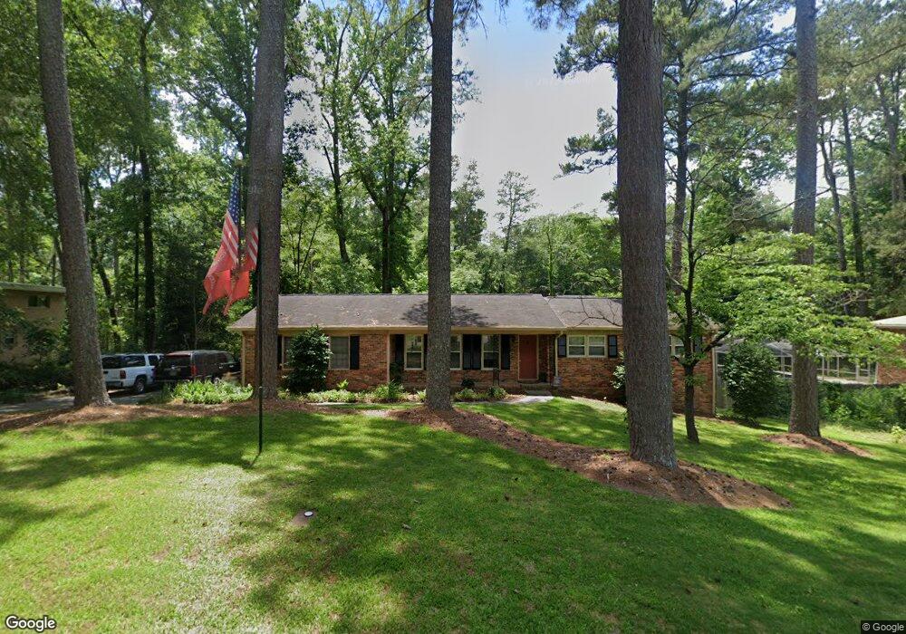
1111 Newport Rd Macon, GA 31210
Estimated Value: $190,000 - $250,000
3
Beds
3
Baths
1,358
Sq Ft
$155/Sq Ft
Est. Value
About This Home
This home is located at 1111 Newport Rd, Macon, GA 31210 and is currently estimated at $210,825, approximately $155 per square foot. 1111 Newport Rd is a home located in Bibb County with nearby schools including Lane Elementary School, Howard Middle School, and Howard High School.
Ownership History
Date
Name
Owned For
Owner Type
Purchase Details
Closed on
Aug 6, 2025
Sold by
Atkinson Ronald W
Bought by
Atkinson Ronald W and Atkinson Elizabeth T
Current Estimated Value
Purchase Details
Closed on
Feb 24, 2021
Sold by
Scarborough Margaret J
Bought by
Atkinson Ronald W
Home Financials for this Owner
Home Financials are based on the most recent Mortgage that was taken out on this home.
Original Mortgage
$143,220
Interest Rate
2.7%
Mortgage Type
VA
Purchase Details
Closed on
May 13, 2005
Sold by
Scarborough James Stanley
Bought by
Scarborough Margaret J
Home Financials for this Owner
Home Financials are based on the most recent Mortgage that was taken out on this home.
Original Mortgage
$59,000
Interest Rate
5.61%
Mortgage Type
New Conventional
Create a Home Valuation Report for This Property
The Home Valuation Report is an in-depth analysis detailing your home's value as well as a comparison with similar homes in the area
Home Values in the Area
Average Home Value in this Area
Purchase History
| Date | Buyer | Sale Price | Title Company |
|---|---|---|---|
| Atkinson Ronald W | -- | None Listed On Document | |
| Atkinson Ronald W | -- | None Listed On Document | |
| Atkinson Ronald W | $140,000 | None Available | |
| Scarborough Margaret J | -- | None Available |
Source: Public Records
Mortgage History
| Date | Status | Borrower | Loan Amount |
|---|---|---|---|
| Previous Owner | Atkinson Ronald W | $143,220 | |
| Previous Owner | Scarborough Margaret J | $59,000 |
Source: Public Records
Tax History Compared to Growth
Tax History
| Year | Tax Paid | Tax Assessment Tax Assessment Total Assessment is a certain percentage of the fair market value that is determined by local assessors to be the total taxable value of land and additions on the property. | Land | Improvement |
|---|---|---|---|---|
| 2025 | $1,247 | $65,337 | $10,000 | $55,337 |
| 2024 | $1,292 | $65,337 | $10,000 | $55,337 |
| 2023 | $1,244 | $48,991 | $8,000 | $40,991 |
| 2022 | $1,861 | $53,753 | $7,706 | $46,047 |
| 2021 | $2,103 | $55,341 | $7,706 | $47,635 |
| 2020 | $1,410 | $43,319 | $6,164 | $37,155 |
| 2019 | $1,422 | $43,319 | $6,164 | $37,155 |
| 2018 | $2,357 | $43,319 | $6,164 | $37,155 |
| 2017 | $1,588 | $42,376 | $5,856 | $36,520 |
| 2016 | $1,291 | $37,305 | $5,548 | $31,757 |
| 2015 | $1,719 | $35,100 | $4,932 | $30,169 |
| 2014 | $1,977 | $35,100 | $4,932 | $30,169 |
Source: Public Records
Map
Nearby Homes
- 1197 Matthews Place
- 1246 Newport Rd
- 1161 Ousley Place
- 938 Lundy Terrace
- 161 Ten Knolls Dr
- 3602 Northside Dr
- 3622 Northside Dr
- 3640 Northside Dr
- 3500 Northside Dr
- 3678 Northside Dr
- 753 Lokchapee Dr
- 731 Lokchapee Dr
- 880 Winchester Cir
- 636 Lokchapee Ridge
- 859 Forest Lake Dr S
- 627 Lokchapee Ridge
- 825 Forest Lake Dr S
- 870 Glen Hill Ct
- 673 Commanche Dr
- 1270 Lake Valley Rd
- 1117 Newport Rd
- 1103 Newport Rd
- 1103 Newport Rd Unit 31210
- 1079 Normandy Rd
- 1114 Newport Rd
- 1123 Newport Rd
- 1102 Newport Rd
- 1142 Matthews Place
- 1071 Normandy Rd
- 1152 Matthews Place
- 1124 Newport Rd
- 1059 Newport Rd
- 1059 Newport Rd Unit 104
- 1129 Newport Rd
- 1078 Normandy Rd
- 1158 Matthews Place
- 1109 Normandy Rd
- 1132 Matthews Place
- 1132 Newport Rd
- 1066 Normandy Rd