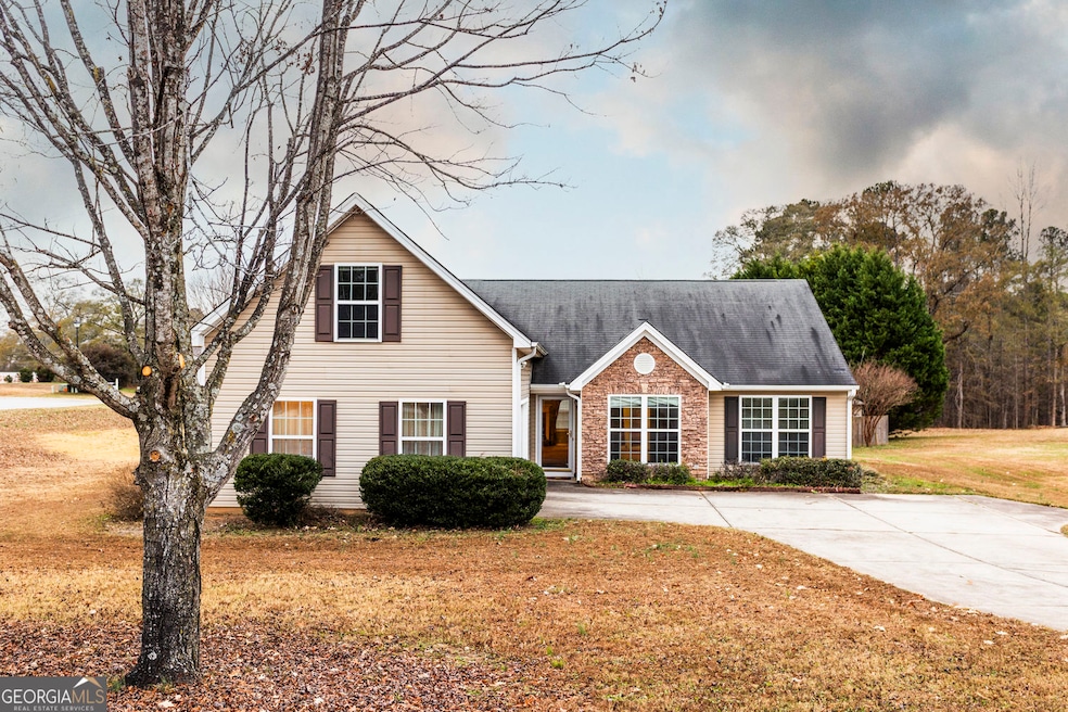
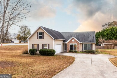


1111 Otis Dr Bethlehem, GA 30620
Estimated payment $1,695/month
Highlights
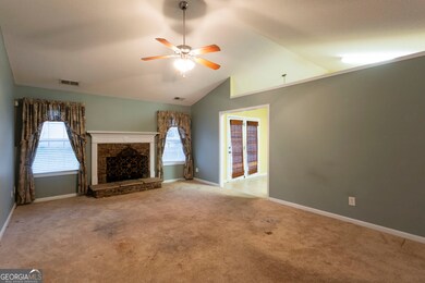
- Vaulted Ceiling
- Wood Flooring
- Formal Dining Room
- Ranch Style House
- Bonus Room
- Double Pane Windows
About This Home
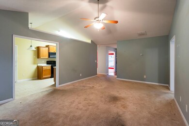
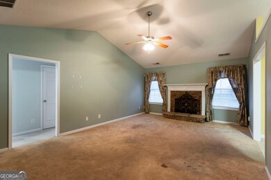
Nestled in the conveniently located neighborhood of Cambridge Estates on a large corner lot, this three bedroom, two bathroom home complete with a bonus room is ready to welcome its new owners. The living room provides a functional space for both relaxation and entertainment, offering high vaulted ceilings that create a sense of spaciousness and light, as well as a fireplace that serves as a warm focal point. The kitchen is located just off of the living room and flows seamlessly into the formal dining area. Featuring a split bedroom plan, the right side of the home includes a spacious primary suite complete with an ensuite with double vanities and separate tub / shower. The opposing side of the home includes two bedrooms & a shared bathroom while the walk-in laundry and finished bonus room can be accessed from the hallway entrance off of the two car garage. This home represents an opportunity to embrace a comfortable lifestyle in a desirable location with a price point that allows room for a few custom touches to make it truly yours.
Home Details
Home Type
- Single Family
Est. Annual Taxes
- $1,652
Year Built
- Built in 2005
Lot Details
- 0.58 Acre Lot
- Level Lot
HOA Fees
- $17 Monthly HOA Fees
Parking
- 2 Car Garage
Home Design
- Ranch Style House
- Slab Foundation
- Composition Roof
- Vinyl Siding
Interior Spaces
- 1,832 Sq Ft Home
- Vaulted Ceiling
- Factory Built Fireplace
- Double Pane Windows
- Living Room with Fireplace
- Formal Dining Room
- Bonus Room
- Fire and Smoke Detector
- Dishwasher
Flooring
- Wood
- Carpet
- Laminate
Bedrooms and Bathrooms
- 3 Main Level Bedrooms
- 2 Full Bathrooms
Laundry
- Laundry Room
- Laundry in Hall
Schools
- Yargo Elementary School
- Haymon Morris Middle School
- Apalachee High School
Utilities
- Central Air
- Heat Pump System
- Well
- Electric Water Heater
- Septic Tank
- Phone Available
Additional Features
- Patio
- Property is near shops
Community Details
- Association fees include management fee
- Cambridge Estates II Subdivision
Listing and Financial Details
- Tax Lot 114
Map
Home Values in the Area
Average Home Value in this Area
Tax History
| Year | Tax Paid | Tax Assessment Tax Assessment Total Assessment is a certain percentage of the fair market value that is determined by local assessors to be the total taxable value of land and additions on the property. | Land | Improvement |
|---|---|---|---|---|
| 2025 | $1,568 | $132,882 | $28,000 | $104,882 |
| 2024 | $1,623 | $129,898 | $28,000 | $101,898 |
| 2023 | $1,654 | $122,750 | $28,000 | $94,750 |
| 2022 | $845 | $86,119 | $22,400 | $63,719 |
| 2021 | $706 | $70,802 | $18,000 | $52,802 |
| 2020 | $673 | $66,435 | $18,000 | $48,435 |
| 2019 | $702 | $66,435 | $18,000 | $48,435 |
| 2018 | $651 | $62,635 | $14,200 | $48,435 |
| 2017 | $1,556 | $53,448 | $14,200 | $39,248 |
| 2016 | $452 | $47,002 | $14,200 | $32,802 |
| 2015 | $459 | $47,358 | $14,200 | $33,158 |
| 2014 | -- | $41,354 | $7,840 | $33,514 |
| 2013 | -- | $39,217 | $7,840 | $31,377 |
Property History
| Date | Event | Price | List to Sale | Price per Sq Ft |
|---|---|---|---|---|
| 01/06/2026 01/06/26 | Pending | -- | -- | -- |
| 12/13/2025 12/13/25 | Price Changed | $297,500 | -6.7% | $162 / Sq Ft |
| 12/03/2025 12/03/25 | For Sale | $319,000 | -- | $174 / Sq Ft |
Purchase History
| Date | Type | Sale Price | Title Company |
|---|---|---|---|
| Deed | $146,000 | -- | |
| Deed | $39,600 | -- | |
| Deed | $38,500 | -- | |
| Deed | -- | -- |
Mortgage History
| Date | Status | Loan Amount | Loan Type |
|---|---|---|---|
| Previous Owner | $124,000 | No Value Available |
Source: Georgia MLS
MLS Number: 10652770
APN: XX053D-147
Disclaimer: Certain information contained herein is derived from information provided by parties other than Homes.com. All information provided is deemed reliable, but is not guaranteed to be accurate and should be independently verified.
![]() The data relating to real estate for sale on this web site comes in part from the Broker Reciprocity Program of Georgia MLS. Real estate listings held by brokerage firms other than Redfin are marked with the Broker Reciprocity logo and detailed information about them includes the name of the listing brokers. Information deemed reliable but not guaranteed. Copyright 2025 Georgia MLS. All rights reserved.
The data relating to real estate for sale on this web site comes in part from the Broker Reciprocity Program of Georgia MLS. Real estate listings held by brokerage firms other than Redfin are marked with the Broker Reciprocity logo and detailed information about them includes the name of the listing brokers. Information deemed reliable but not guaranteed. Copyright 2025 Georgia MLS. All rights reserved.
- 1129 Loganville Hwy
- 209 Angie Way
- 630 Bridle Creek Dr
- 609 Mcdowell Ln
- 738 Worth Ct
- 720 Westbury Ct
- 724 Westbury Dr
- 704 Newnham Walk
- 631 Saddle Ridge Dr
- 713 Carl Bethlehem Rd
- 1309 Tom Miller Rd
- 449 Carl Bethlehem Rd SW
- 1188 Carl-Bethlehem Rd
- 934 Beaver Hill Dr
- 0 Jb Owens Unit 7552902
- 0 Jb Owens Unit 7552891
- 0 Jb Owens Unit LOT 2 - 2.09 ACRES
- 0 Jb Owens Unit LOT 3 - 2.01 ACRES
- 1513 Pointe South Cir
- 190 Lokeys Ln
