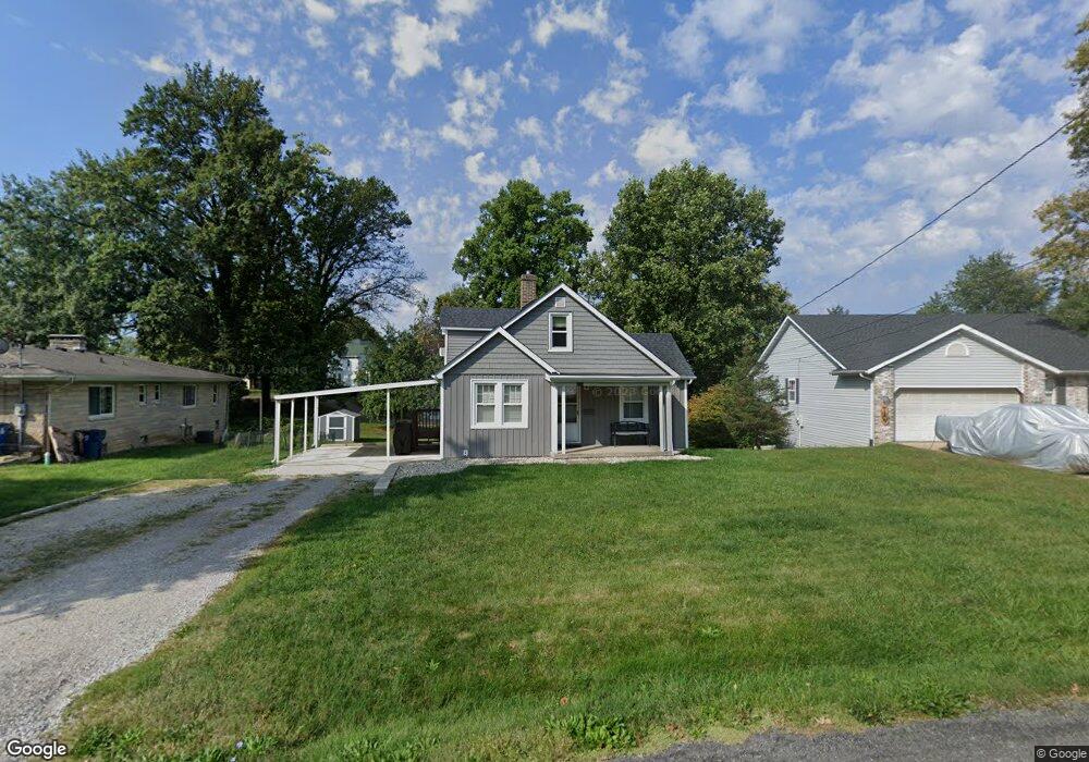
1111 Williams St Collinsville, IL 62234
Estimated Value: $118,000 - $166,740
2
Beds
1
Bath
992
Sq Ft
$147/Sq Ft
Est. Value
About This Home
This home is located at 1111 Williams St, Collinsville, IL 62234 and is currently estimated at $145,685, approximately $146 per square foot. 1111 Williams St is a home located in Madison County with nearby schools including John A Renfro Elementary School, Dorris Intermediate School, and Collinsville Middle School.
Ownership History
Date
Name
Owned For
Owner Type
Purchase Details
Closed on
Feb 20, 2004
Sold by
Taake Margaret C and Taske Everett
Bought by
Burns Sandra J
Current Estimated Value
Home Financials for this Owner
Home Financials are based on the most recent Mortgage that was taken out on this home.
Original Mortgage
$62,400
Outstanding Balance
$29,082
Interest Rate
5.74%
Mortgage Type
Purchase Money Mortgage
Estimated Equity
$116,603
Create a Home Valuation Report for This Property
The Home Valuation Report is an in-depth analysis detailing your home's value as well as a comparison with similar homes in the area
Home Values in the Area
Average Home Value in this Area
Purchase History
| Date | Buyer | Sale Price | Title Company |
|---|---|---|---|
| Burns Sandra J | $78,000 | Abstracts & Titles Inc |
Source: Public Records
Mortgage History
| Date | Status | Borrower | Loan Amount |
|---|---|---|---|
| Open | Burns Sandra J | $62,400 |
Source: Public Records
Tax History Compared to Growth
Tax History
| Year | Tax Paid | Tax Assessment Tax Assessment Total Assessment is a certain percentage of the fair market value that is determined by local assessors to be the total taxable value of land and additions on the property. | Land | Improvement |
|---|---|---|---|---|
| 2024 | $2,835 | $50,350 | $7,200 | $43,150 |
| 2023 | $2,835 | $46,600 | $6,660 | $39,940 |
| 2022 | $2,672 | $41,780 | $5,960 | $35,820 |
| 2021 | $2,297 | $39,250 | $5,600 | $33,650 |
| 2020 | $2,195 | $37,450 | $5,340 | $32,110 |
| 2019 | $2,123 | $36,170 | $5,160 | $31,010 |
| 2018 | $1,714 | $29,470 | $4,870 | $24,600 |
| 2017 | $1,707 | $28,880 | $4,770 | $24,110 |
| 2016 | $1,788 | $28,880 | $4,770 | $24,110 |
| 2015 | $1,657 | $28,130 | $4,650 | $23,480 |
| 2014 | $1,657 | $28,130 | $4,650 | $23,480 |
| 2013 | $1,657 | $28,130 | $4,650 | $23,480 |
Source: Public Records
Map
Nearby Homes
- 1120 Williams St
- 1210 Constance St
- 308 Brown Ave
- 501 Spring
- 1224 Cedar Ridge Ct
- 617 N Morrison Ave
- 203 Greenfield Dr
- 123 W Wickliffe Ave
- 0 N Keebler Ave
- 919 Vine St
- 0 Strong Ave
- 1227 Ridge Ave
- 921 Prospect St
- 706 Illinois Ave
- 414 Bunker Hill Dr
- 22 Brookwood Dr
- 5 Brookwood Dr
- 123 Elliot St
- 580 N Guernsey St
- 238 Mill St
- 901 Harding St
- 1113 Williams St
- 315 Wadsworth St
- 1115 Williams St
- 319 Wadsworth St
- 1117 Williams St
- 415 Wadsworth St
- 1114 Williams St
- 400 Wadsworth St
- 111 Harding St
- 406 Wadsworth St
- 1123 Williams St
- 1116 Williams St
- 417 Wadsworth St
- 400 Rebecca Ave
- 408 Wadsworth St
- 320 Wadsworth St
- 320 Wadsworth St Unit CLAY
- 320 Wadsworth St
- 1120 Williams St Unit 1120 WILLAMS ST APT