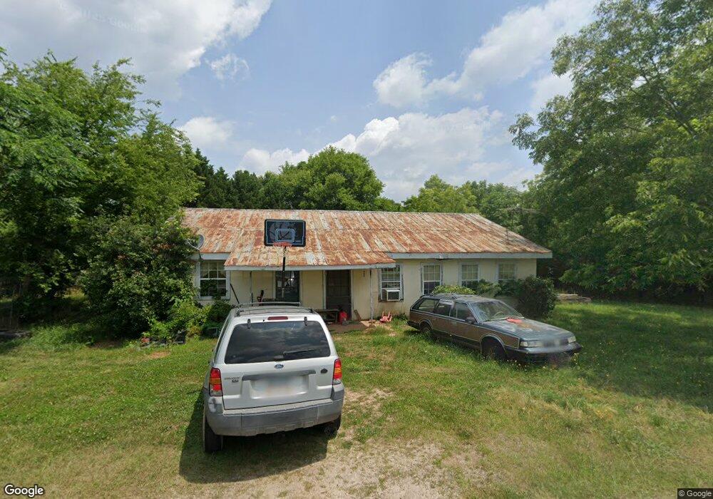
1111 Wyatt Rd Union Point, GA 30669
Estimated Value: $79,391 - $250,000
--
Bed
1
Bath
1,632
Sq Ft
$100/Sq Ft
Est. Value
About This Home
This home is located at 1111 Wyatt Rd, Union Point, GA 30669 and is currently estimated at $163,348, approximately $100 per square foot. 1111 Wyatt Rd is a home located in Greene County with nearby schools including Greene County High School.
Ownership History
Date
Name
Owned For
Owner Type
Purchase Details
Closed on
Oct 8, 2018
Sold by
Jarrell Janet B
Bought by
Phillips Sara
Current Estimated Value
Purchase Details
Closed on
Apr 24, 1997
Sold by
Jarrell Larry
Bought by
Jarrell Larry and Jarrell Janet B
Purchase Details
Closed on
Jan 1, 1988
Sold by
Jarrell Thomas Edwin
Bought by
Jarrell Larry
Purchase Details
Closed on
Jan 1, 1984
Sold by
Jarrell Charles Larry
Bought by
Jarrell Thomas Edwin
Purchase Details
Closed on
Jan 1, 1956
Bought by
Jarrell Edwin
Create a Home Valuation Report for This Property
The Home Valuation Report is an in-depth analysis detailing your home's value as well as a comparison with similar homes in the area
Home Values in the Area
Average Home Value in this Area
Purchase History
| Date | Buyer | Sale Price | Title Company |
|---|---|---|---|
| Phillips Sara | -- | -- | |
| Jarrell Larry | -- | -- | |
| Jarrell Larry | -- | -- | |
| Jarrell Thomas Edwin | -- | -- | |
| Jarrell Charles Larry | -- | -- | |
| Jarrell Edwin | -- | -- |
Source: Public Records
Tax History Compared to Growth
Tax History
| Year | Tax Paid | Tax Assessment Tax Assessment Total Assessment is a certain percentage of the fair market value that is determined by local assessors to be the total taxable value of land and additions on the property. | Land | Improvement |
|---|---|---|---|---|
| 2024 | $529 | $17,360 | $4,240 | $13,120 |
| 2023 | $501 | $16,240 | $3,520 | $12,720 |
| 2022 | $402 | $12,360 | $2,720 | $9,640 |
| 2021 | $389 | $11,240 | $2,720 | $8,520 |
| 2020 | $375 | $9,760 | $1,800 | $7,960 |
| 2019 | $379 | $9,760 | $1,800 | $7,960 |
| 2018 | $356 | $9,760 | $1,800 | $7,960 |
| 2017 | $344 | $9,819 | $1,825 | $7,994 |
| 2016 | $344 | $9,819 | $1,825 | $7,994 |
| 2015 | $318 | $9,819 | $1,825 | $7,994 |
| 2014 | $315 | $9,611 | $1,825 | $7,786 |
Source: Public Records
Map
Nearby Homes
- 5011 Penfield Rd
- 1101 Boswell Rd
- 5971 Penfield Rd
- 3021 Penfield Rd
- 1211 Peachtree Ave W
- 0 Woodville Rd Unit 7667944
- 0 Woodville Rd Unit 10628010
- 3434 Union Point Rd
- 0 Dogwood Rd
- 1251 Adams Rd
- 0 Cold Springs Rd Unit 25814506
- 1110 Woodland Way
- 1110 Woodland Ln
- 204 Maple St
- 0 Union Point Hwy Unit 10555176
- 0 Union Point Hwy Unit 7607786
- 0 Shady Side Ln
- 0 Old Union Point Rd Unit 1 10557753
- 1020 Horton Dr
- 0 Railroad St Unit 10578007
- 1031 Wyatt Rd
- 1080 Maxeys Rd
- 1080 Old Maxey's Rd
- 1400 Maxeys Rd
- 1160 Cemetery Rd
- 1170 Maxeys Rd
- 1851 Maxey's Rd
- 1011 Wyatt Rd
- 1011 Wyatt Rd Unit 1011 L L WYATT
- L L Wyatt Rd
- 1070 Maxeys Rd
- 1030 Maxeys Rd
- 1030 Cemetery Rd
- 4850 Penfield Rd
- 4980 Penfield Rd
- 5020 Penfield Rd
- 1161 Cemetery Rd
- 0 Beasley Cir Unit 8289084
- 4991 Penfield Rd
- 5080 Penfield Rd