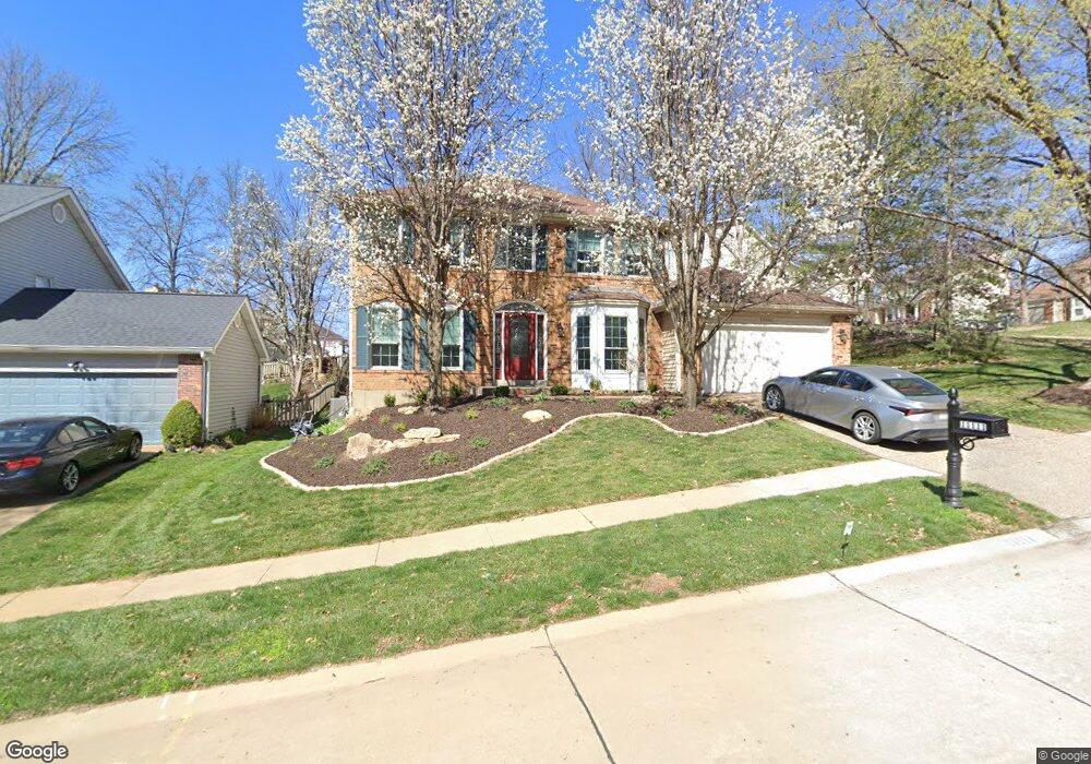
11111 Apache Trail Saint Louis, MO 63146
Estimated Value: $395,653 - $484,000
3
Beds
3
Baths
2,170
Sq Ft
$198/Sq Ft
Est. Value
About This Home
This home is located at 11111 Apache Trail, Saint Louis, MO 63146 and is currently estimated at $429,663, approximately $198 per square foot. 11111 Apache Trail is a home located in St. Louis County with nearby schools including Willow Brook Elementary School, Pattonville Heights Middle School, and Pattonville High School.
Ownership History
Date
Name
Owned For
Owner Type
Purchase Details
Closed on
Jan 5, 2018
Sold by
Pesigan Glenn F and Pesigan Cynthia L
Bought by
Pesigan Glenn F and Pesigan Cynthia L
Current Estimated Value
Purchase Details
Closed on
Aug 15, 1997
Sold by
Becker Jackie S and Becker William J
Bought by
Pesigan Glenn F and Pesigan Cynthia L
Home Financials for this Owner
Home Financials are based on the most recent Mortgage that was taken out on this home.
Original Mortgage
$166,000
Outstanding Balance
$24,707
Interest Rate
7.46%
Estimated Equity
$404,956
Create a Home Valuation Report for This Property
The Home Valuation Report is an in-depth analysis detailing your home's value as well as a comparison with similar homes in the area
Home Values in the Area
Average Home Value in this Area
Purchase History
| Date | Buyer | Sale Price | Title Company |
|---|---|---|---|
| Pesigan Glenn F | -- | None Available | |
| Pesigan Glenn F | -- | -- |
Source: Public Records
Mortgage History
| Date | Status | Borrower | Loan Amount |
|---|---|---|---|
| Open | Pesigan Glenn F | $166,000 |
Source: Public Records
Tax History Compared to Growth
Tax History
| Year | Tax Paid | Tax Assessment Tax Assessment Total Assessment is a certain percentage of the fair market value that is determined by local assessors to be the total taxable value of land and additions on the property. | Land | Improvement |
|---|---|---|---|---|
| 2025 | $4,261 | $68,500 | $12,790 | $55,710 |
| 2024 | $4,261 | $60,840 | $6,800 | $54,040 |
| 2023 | $4,277 | $60,840 | $6,800 | $54,040 |
| 2022 | $4,417 | $57,210 | $10,220 | $46,990 |
| 2021 | $4,393 | $57,210 | $10,220 | $46,990 |
| 2020 | $4,258 | $53,240 | $10,220 | $43,020 |
| 2019 | $4,231 | $53,240 | $10,220 | $43,020 |
| 2018 | $4,268 | $49,250 | $10,220 | $39,030 |
| 2017 | $4,279 | $49,250 | $10,220 | $39,030 |
| 2016 | $4,615 | $52,150 | $11,910 | $40,240 |
| 2015 | $4,546 | $52,150 | $11,910 | $40,240 |
| 2014 | $4,276 | $48,600 | $9,610 | $38,990 |
Source: Public Records
Map
Nearby Homes
- 1060 Port Diane Dr
- 50 Willow Brook Dr
- 1033 Wilton Royal Dr Unit 210
- 1033 Wilton Royal Dr Unit 107
- 1033 Wilton Royal Dr Unit 204
- 1054 Willow Brook Dr
- 10401 Briarbend Dr Unit 2
- 10469 Briarbend Dr Unit 3
- 1279 Guelbreth Ln Unit 210
- 10387 Forest Brook Ln
- 1251 Guelbreth Ln Unit 308
- 10352 Forest Brook Ln Unit H
- 10381 Oxford Hill Dr Unit 24
- 10381 Oxford Hill Dr Unit 14
- 10381 Oxford Hill Dr Unit 6
- 10344 Forest Brook Ln Unit C
- 10367 Oxford Hill Dr Unit 14
- 10367 Oxford Hill Dr Unit 6
- 10367 Oxford Hill Dr Unit 26
- 942 Guelbreth Ln Unit 200
- 1107 Dunston Dr
- 11117 Apache Trail
- 11123 Apache Trail
- 1111 Dunston Dr
- 11180 Fairborough Ct
- 11112 Apache Trail
- 11106 Apache Trail
- 11118 Apache Trail
- 1106 Dunston Dr
- 11185 Fairborough Ct
- 1110 Dunston Dr
- 1117 Dunston Dr
- 11129 Apache Trail
- 11124 Apache Trail
- 1114 Dunston Dr
- 11100 Apache Trail
- 11174 Fairborough Ct
- 1102 Dunston Dr
- 11130 Apache Trail
- 1118 Dunston Dr