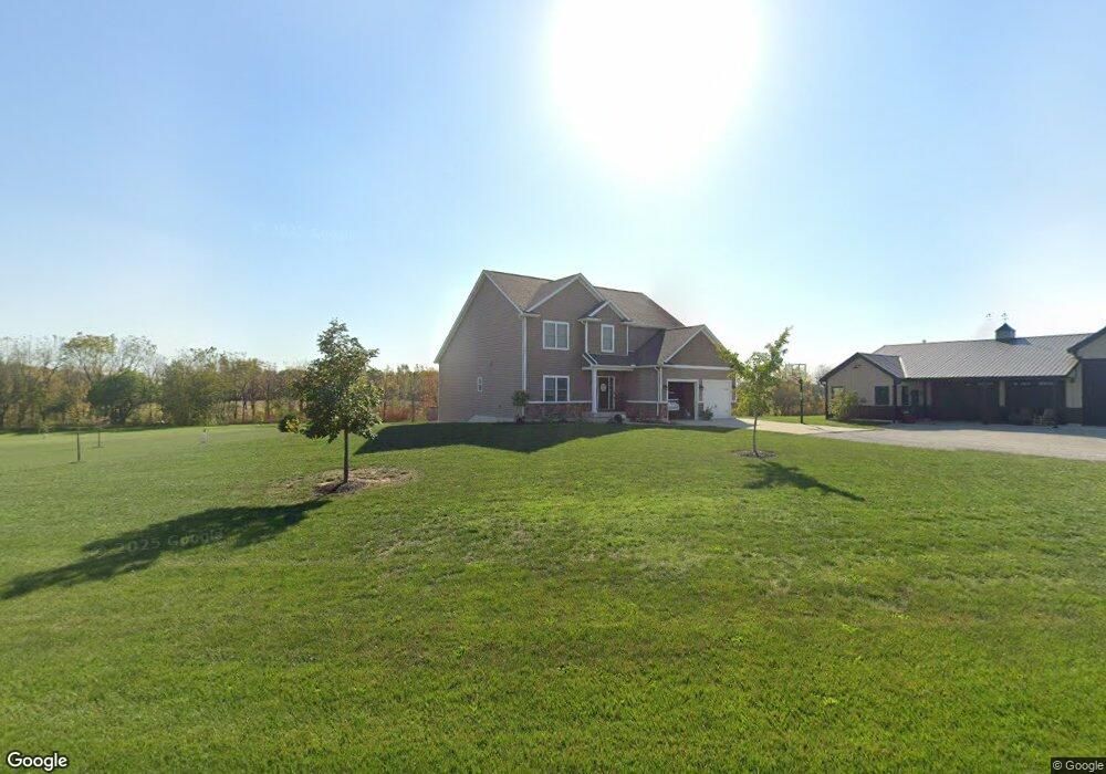
11117 State Route 185 Versailles, OH 45380
Estimated Value: $436,000 - $593,755
4
Beds
3
Baths
2,811
Sq Ft
$175/Sq Ft
Est. Value
About This Home
This home is located at 11117 State Route 185, Versailles, OH 45380 and is currently estimated at $491,439, approximately $174 per square foot. 11117 State Route 185 is a home located in Darke County with nearby schools including Versailles Elementary School, Versailles Middle School, and Versailles High School.
Ownership History
Date
Name
Owned For
Owner Type
Purchase Details
Closed on
Jul 13, 2020
Sold by
Lost C Inc
Bought by
Rogers Chad W and Rogers Beth A
Current Estimated Value
Home Financials for this Owner
Home Financials are based on the most recent Mortgage that was taken out on this home.
Original Mortgage
$271,600
Outstanding Balance
$191,891
Interest Rate
3.1%
Mortgage Type
New Conventional
Estimated Equity
$299,548
Purchase Details
Closed on
May 4, 2005
Sold by
Rinderle Chris
Bought by
Fleckenstein Roger and Fleckenstein Teresa R
Purchase Details
Closed on
Aug 7, 2004
Sold by
Rescom Ltd
Bought by
Rinderle Chris
Home Financials for this Owner
Home Financials are based on the most recent Mortgage that was taken out on this home.
Original Mortgage
$15,920
Interest Rate
6.35%
Mortgage Type
Purchase Money Mortgage
Create a Home Valuation Report for This Property
The Home Valuation Report is an in-depth analysis detailing your home's value as well as a comparison with similar homes in the area
Home Values in the Area
Average Home Value in this Area
Purchase History
| Date | Buyer | Sale Price | Title Company |
|---|---|---|---|
| Rogers Chad W | -- | None Available | |
| Fleckenstein Roger | $21,000 | -- | |
| Rinderle Chris | $19,900 | -- |
Source: Public Records
Mortgage History
| Date | Status | Borrower | Loan Amount |
|---|---|---|---|
| Open | Rogers Chad W | $271,600 | |
| Previous Owner | Rinderle Chris | $15,920 |
Source: Public Records
Tax History Compared to Growth
Tax History
| Year | Tax Paid | Tax Assessment Tax Assessment Total Assessment is a certain percentage of the fair market value that is determined by local assessors to be the total taxable value of land and additions on the property. | Land | Improvement |
|---|---|---|---|---|
| 2024 | $4,630 | $139,960 | $13,200 | $126,760 |
| 2023 | $4,636 | $139,960 | $13,200 | $126,760 |
| 2022 | $3,878 | $120,770 | $11,480 | $109,290 |
| 2021 | $4,063 | $120,770 | $11,480 | $109,290 |
| 2020 | $3,934 | $116,390 | $11,480 | $104,910 |
| 2019 | $2,954 | $87,750 | $11,480 | $76,270 |
| 2018 | $2,921 | $87,750 | $11,480 | $76,270 |
| 2017 | $2,941 | $86,390 | $11,480 | $74,910 |
| 2016 | $3,022 | $92,590 | $9,820 | $82,770 |
| 2015 | $3,022 | $92,590 | $9,820 | $82,770 |
| 2014 | $214 | $6,110 | $6,110 | $0 |
| 2013 | $230 | $6,110 | $6,110 | $0 |
Source: Public Records
Map
Nearby Homes
- 00 State Route 121
- 0 St Rt 121 Unit 10041143
- 1031 Baker Rd
- 1025 Baker Rd
- 632 N Center St
- 631 N Center St
- 552 Reed Ave
- 546 Reed Ave
- 8839 Murphy Rd
- 547 Reed Ave
- 59 W Ward St
- 0 Ohio 121
- 435 Reed Ave
- 447 Reed Ave
- 129 E Wood St
- 304 E Wood St
- 0000 Marker Rd
- 5226 Riffle Rd
- 6109 Beamsville Union City Rd
- 6099 Beamsville Union City Rd
- 11121 State Route 185
- 11121 Ohio 185
- 11140 State Route 185
- 11193 State Route 185
- 7839 Burns Rd
- 11198 State Route 185
- 11198 Ohio 185
- 11195 State Route 185
- 11060 State Route 185
- 11203 State Route 185
- 11208 Ohio 185
- 11208 State Route 185
- 11213 State Route 185
- 11218 State Route 185
- 317 Riffle Ave
- 11256 State Route 185
- 11268 State Route 185
- 7787 Burns Rd
- 11263 State Route 185
- 11013 State Route 185