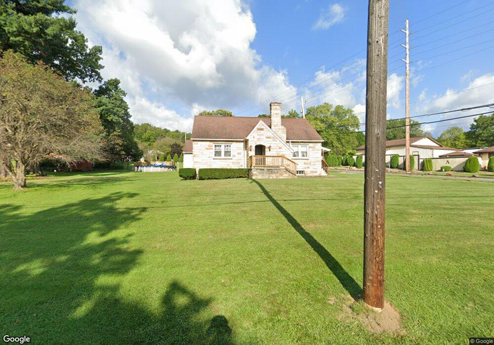
1112 Broadway St Masury, OH 44438
Estimated Value: $126,000 - $160,000
3
Beds
1
Bath
1,537
Sq Ft
$92/Sq Ft
Est. Value
About This Home
This home is located at 1112 Broadway St, Masury, OH 44438 and is currently estimated at $141,247, approximately $91 per square foot. 1112 Broadway St is a home located in Trumbull County with nearby schools including Brookfield Elementary School, Brookfield Middle School, and Brookfield High School.
Ownership History
Date
Name
Owned For
Owner Type
Purchase Details
Closed on
Aug 8, 2019
Sold by
Phillips Tisha Marie
Bought by
Root Leah M and Schell Randall L
Current Estimated Value
Home Financials for this Owner
Home Financials are based on the most recent Mortgage that was taken out on this home.
Original Mortgage
$73,150
Outstanding Balance
$63,800
Interest Rate
3.5%
Mortgage Type
FHA
Estimated Equity
$77,447
Purchase Details
Closed on
Aug 18, 2018
Sold by
Phillips Dale L
Bought by
Phillips Tisha Marie
Purchase Details
Closed on
Jan 1, 1990
Bought by
Alton Alton E and Alton S
Create a Home Valuation Report for This Property
The Home Valuation Report is an in-depth analysis detailing your home's value as well as a comparison with similar homes in the area
Home Values in the Area
Average Home Value in this Area
Purchase History
| Date | Buyer | Sale Price | Title Company |
|---|---|---|---|
| Root Leah M | $74,500 | None Available | |
| Phillips Tisha Marie | -- | None Available | |
| Alton Alton E | -- | -- |
Source: Public Records
Mortgage History
| Date | Status | Borrower | Loan Amount |
|---|---|---|---|
| Open | Root Leah M | $73,150 |
Source: Public Records
Tax History Compared to Growth
Tax History
| Year | Tax Paid | Tax Assessment Tax Assessment Total Assessment is a certain percentage of the fair market value that is determined by local assessors to be the total taxable value of land and additions on the property. | Land | Improvement |
|---|---|---|---|---|
| 2024 | $1,567 | $33,220 | $4,380 | $28,840 |
| 2023 | $1,567 | $33,220 | $4,380 | $28,840 |
| 2022 | $1,344 | $23,110 | $4,380 | $18,730 |
| 2021 | $1,261 | $23,110 | $4,380 | $18,730 |
| 2020 | $1,254 | $23,110 | $4,380 | $18,730 |
| 2019 | $1,283 | $22,060 | $4,380 | $17,680 |
| 2018 | $750 | $22,060 | $4,380 | $17,680 |
| 2017 | $749 | $22,060 | $4,380 | $17,680 |
| 2016 | $831 | $22,970 | $4,380 | $18,590 |
| 2015 | $833 | $22,970 | $4,380 | $18,590 |
| 2014 | $833 | $23,040 | $4,450 | $18,590 |
| 2013 | $898 | $24,440 | $4,450 | $19,990 |
Source: Public Records
Map
Nearby Homes
- 1354 Stevenson Rd
- 7440 Stewart Sharon Rd
- 928 Bedford Rd
- 766 S Irvine Ave
- 7182 Stewart Sharon Rd
- 545 & 625 Davis St
- 691 S Irvine Ave
- 609 Syme St
- 365 Brookfield Ave
- 1952 Hubbard Masury Rd
- 887 State Route 7 SE
- 807 Lee Ave
- 306 Federal St
- 6855 Stewart Sharon Rd
- 506 Spearman Ave
- 268 Malleable St
- 1120 Wallis Ave
- 626 Fruit Ave
- 641 Fruit Ave
- 872 Yankee Run Rd
- 1126 Broadway St
- 1100 Broadway Rd
- 1117 Broadway St
- 1117 Woodland Ave
- 1117 Woodland Ave
- 1133 Broadway St
- 1111 Broadway St
- 1119 Woodland Ave
- 1111 & 1117 Broadway
- 1111 Broadway Ave
- 1107 Broadway St
- 1137 Broadway St
- 1090 Broadway St
- 1141 Broadway St
- 7810 Rose Ave
- 7810 Rose Ave
- 1103 Broadway St
- 1086 Broadway St
- 1145 Broadway St
- 1112 Woodland Ave