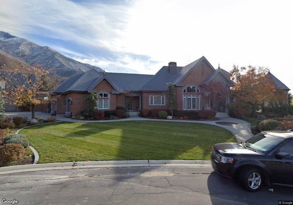
1112 Falcon Cir Mapleton, UT 84664
Estimated Value: $2,631,000 - $2,682,640
5
Beds
4
Baths
6,648
Sq Ft
$400/Sq Ft
Est. Value
About This Home
This home is located at 1112 Falcon Cir, Mapleton, UT 84664 and is currently estimated at $2,656,820, approximately $399 per square foot. 1112 Falcon Cir is a home located in Utah County with nearby schools including Mapleton School, Mapleton Junior High School, and Maple Mountain High School.
Ownership History
Date
Name
Owned For
Owner Type
Purchase Details
Closed on
Dec 22, 2021
Sold by
Maya Trust
Bought by
Ch Residential Llc
Current Estimated Value
Purchase Details
Closed on
Apr 27, 2016
Sold by
Hill David K
Bought by
Hill Creselda and The Maya Trust
Purchase Details
Closed on
May 8, 2012
Sold by
Allen Lori B
Bought by
Hill David K
Home Financials for this Owner
Home Financials are based on the most recent Mortgage that was taken out on this home.
Original Mortgage
$417,000
Interest Rate
3.94%
Mortgage Type
New Conventional
Purchase Details
Closed on
Apr 2, 2008
Sold by
Allen Marvin R and Allen Lori B
Bought by
Allen Lori B
Purchase Details
Closed on
Dec 20, 2007
Sold by
Allen Marvin R
Bought by
Allen Lori B
Purchase Details
Closed on
Aug 26, 2002
Sold by
Allen Marvin R
Bought by
Allen Marvin R and Allen Lori B
Home Financials for this Owner
Home Financials are based on the most recent Mortgage that was taken out on this home.
Original Mortgage
$622,600
Interest Rate
6.43%
Purchase Details
Closed on
Aug 30, 2001
Sold by
Allen Marvin R and Allen Lori B
Bought by
Allen Marvin R and Allen Lori B
Home Financials for this Owner
Home Financials are based on the most recent Mortgage that was taken out on this home.
Original Mortgage
$80,000
Interest Rate
7.05%
Purchase Details
Closed on
Jul 1, 1999
Sold by
Allen Marvin and Allen Lori B
Bought by
Allen Marvin R and Allen Lori B
Home Financials for this Owner
Home Financials are based on the most recent Mortgage that was taken out on this home.
Original Mortgage
$692,000
Interest Rate
7.2%
Purchase Details
Closed on
Mar 22, 1999
Sold by
Allen Lori B
Bought by
Allen Marvin R and Allen Lori B
Purchase Details
Closed on
Jun 10, 1998
Sold by
Sommerset Park L C
Bought by
Allen Marvin and Allen Lori B
Home Financials for this Owner
Home Financials are based on the most recent Mortgage that was taken out on this home.
Original Mortgage
$78,000
Interest Rate
7.11%
Mortgage Type
Seller Take Back
Create a Home Valuation Report for This Property
The Home Valuation Report is an in-depth analysis detailing your home's value as well as a comparison with similar homes in the area
Home Values in the Area
Average Home Value in this Area
Purchase History
| Date | Buyer | Sale Price | Title Company |
|---|---|---|---|
| Ch Residential Llc | -- | None Listed On Document | |
| Hill Creselda | -- | None Available | |
| Hill David K | -- | Pro Title And Escrow Inc | |
| Allen Lori B | -- | None Available | |
| Allen Lori B | -- | None Available | |
| Allen Marvin R | -- | -- | |
| Allen Marvin R | -- | Backman Stewart Title Servi | |
| Allen Marvin R | -- | Titlewriters Inc | |
| Allen Marvin R | -- | Titlewriters Inc | |
| Allen Marvin R | -- | Mountain West Title Co | |
| Allen Marvin | -- | Mountain West Title Co | |
| Allen Marvin R | -- | -- | |
| Allen Lori B | -- | -- | |
| Allen Marvin | -- | -- |
Source: Public Records
Mortgage History
| Date | Status | Borrower | Loan Amount |
|---|---|---|---|
| Previous Owner | Hill David K | $417,000 | |
| Previous Owner | Allen Marvin R | $622,600 | |
| Previous Owner | Allen Marvin R | $80,000 | |
| Previous Owner | Allen Marvin | $692,000 | |
| Previous Owner | Allen Marvin | $78,000 |
Source: Public Records
Tax History
| Year | Tax Paid | Tax Assessment Tax Assessment Total Assessment is a certain percentage of the fair market value that is determined by local assessors to be the total taxable value of land and additions on the property. | Land | Improvement |
|---|---|---|---|---|
| 2025 | $12,718 | $1,383,010 | -- | -- |
| 2024 | $12,718 | $1,245,905 | $0 | $0 |
| 2023 | $12,594 | $1,241,560 | $0 | $0 |
| 2022 | $13,650 | $2,397,900 | $619,800 | $1,778,100 |
| 2021 | $11,536 | $1,709,500 | $341,700 | $1,367,800 |
| 2020 | $11,384 | $1,633,200 | $318,000 | $1,315,200 |
| 2019 | $9,046 | $1,321,900 | $298,000 | $1,023,900 |
| 2018 | $8,661 | $1,206,300 | $284,600 | $921,700 |
| 2017 | $8,009 | $597,875 | $0 | $0 |
| 2016 | $6,301 | $537,760 | $0 | $0 |
| 2015 | $6,409 | $472,695 | $0 | $0 |
| 2014 | $6,041 | $437,560 | $0 | $0 |
Source: Public Records
Map
Nearby Homes
- 644 S 1330 E
- 4021 S Ironwood Ln Unit 428
- 4886 S Englemann Ln Unit 525
- 2254 715 S Unit 60
- 4013 S Ironwood Ln Unit 432
- 4014 S Ironwood Ln
- 4001 S Ironwood Ln Unit 438
- 2254 715 S
- 4012 S Ironwood Ln Unit 424
- 2042 715 S Unit 57
- 4019 S Ironwood Ln Unit 429
- 2042 715 S
- 1759 S Perry Dr
- 753 Sierra View Dr
- 575 S 1560 E
- 748 Sierra View Dr
- 1377 E Maple St
- 745 E Maple St
- 1974 S Preserve Dr Unit 56
- 1906 S Preserve Dr
- 1156 Falcon Cir
- 1156 Falcon Cir Unit 20
- 1090 Falcon Cir
- 1171 E Falcon St Unit 16
- 1117 Falcon Cir
- 1005 S 800 E
- 1190 E Falcon St
- 1190 Falcon Cir
- 1171 Falcon Cir
- 834 S 1250 E
- 875 S 1250 E
- 696 S 1200 E
- 930 S 1250 E
- 1086 Hawks Rest Dr
- 922 S 1000 E
- 1086 Hawks Rest Dr
- 905 S 1250 E
- 1000 S 1000 E
- 1034 Hawks Rest Dr
- 1179 S North Pond Cir
Your Personal Tour Guide
Ask me questions while you tour the home.