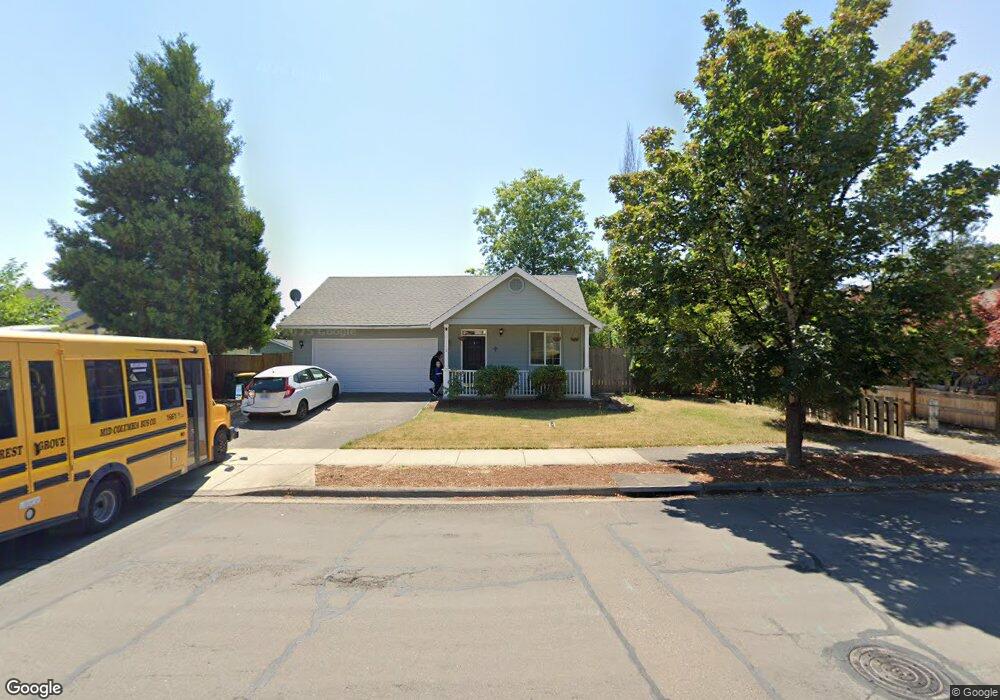
1112 Nichols Ln Forest Grove, OR 97116
Estimated Value: $409,000 - $512,000
3
Beds
1
Bath
1,107
Sq Ft
$403/Sq Ft
Est. Value
About This Home
This home is located at 1112 Nichols Ln, Forest Grove, OR 97116 and is currently estimated at $446,027, approximately $402 per square foot. 1112 Nichols Ln is a home located in Washington County with nearby schools including Harvey Clarke Elementary School, Tom McCall Upper Elementary School, and Neil Armstrong Middle School.
Ownership History
Date
Name
Owned For
Owner Type
Purchase Details
Closed on
Dec 27, 2012
Sold by
Richards Nancy M
Bought by
The Motz Properties Llc
Current Estimated Value
Purchase Details
Closed on
Aug 28, 2012
Sold by
Richards Nancy M
Bought by
Motz Donald L
Purchase Details
Closed on
Dec 30, 2011
Sold by
Motz Donald L
Bought by
The Motz Properties Llc
Purchase Details
Closed on
Apr 10, 1997
Sold by
Skyline Development Inc
Bought by
Motz Donald L and Motz Shirley M
Create a Home Valuation Report for This Property
The Home Valuation Report is an in-depth analysis detailing your home's value as well as a comparison with similar homes in the area
Home Values in the Area
Average Home Value in this Area
Purchase History
| Date | Buyer | Sale Price | Title Company |
|---|---|---|---|
| The Motz Properties Llc | -- | None Available | |
| Motz Donald L | -- | None Available | |
| The Motz Properties Llc | -- | None Available | |
| Motz Donald L | $122,520 | First American Title Ins Co |
Source: Public Records
Tax History Compared to Growth
Tax History
| Year | Tax Paid | Tax Assessment Tax Assessment Total Assessment is a certain percentage of the fair market value that is determined by local assessors to be the total taxable value of land and additions on the property. | Land | Improvement |
|---|---|---|---|---|
| 2026 | $4,175 | $234,420 | -- | -- |
| 2025 | $4,175 | $227,600 | -- | -- |
| 2024 | $4,027 | $220,980 | -- | -- |
| 2023 | $4,027 | $214,550 | $0 | $0 |
| 2022 | $3,522 | $214,550 | $0 | $0 |
| 2021 | $3,476 | $202,250 | $0 | $0 |
| 2020 | $3,457 | $196,360 | $0 | $0 |
| 2019 | $3,380 | $190,650 | $0 | $0 |
| 2018 | $3,277 | $185,100 | $0 | $0 |
| 2017 | $3,175 | $179,710 | $0 | $0 |
| 2016 | $3,086 | $174,480 | $0 | $0 |
| 2015 | $2,967 | $169,400 | $0 | $0 |
| 2014 | $2,953 | $164,470 | $0 | $0 |
Source: Public Records
Map
Nearby Homes
- 1224 Alyssum Ave
- 922 Rosebud Ct
- 918 Rosebud Ct
- 911 Rosebud Ct
- 920 Rosebud Ct
- 924 Rosebud Ct
- 3309 Butte Dr
- 507-FH Plan at Parkview Terrace
- 504-STD Plan at Parkview Terrace
- Poppy - Plan 308C at Parkview Terrace
- 430A Plan at Parkview Terrace
- Plan 400 at Parkview Terrace
- 506-FH Plan at Parkview Terrace
- Plan 325 at Parkview Terrace
- 505-STD Plan at Parkview Terrace
- 508-MFH Plan at Parkview Terrace
- 3245 Butte Dr
- 504-FH Plan at Parkview Terrace
- 506-STD Plan at Parkview Terrace
- 322 MFH 3 Plan at Parkview Terrace
- 1114 Nichols Ln
- 1110 Nichols Ln
- 1113 Alyssum Ave
- 1111 Alyssum Ave
- 1116 Nichols Ln
- 1108 Nichols Ln
- 1115 Alyssum Ave
- 3132 Twinflower St
- 1107 Nichols Ln
- 1117 Nichols Ln
- 1080 Nichols Ln
- 1117 Alyssum Ave
- 1113 Nichols Ln
- 1118 Nichols Ln
- 1103 Nichols Ln
- 3126 Twinflower St
- 1119 Nichols Ln
- 1119 Alyssum Ave
- 1112 Alyssum Ave
- 3208 Larrabee St