Estimated Value: $133,000 - $152,000
3
Beds
1
Bath
1,144
Sq Ft
$123/Sq Ft
Est. Value
About This Home
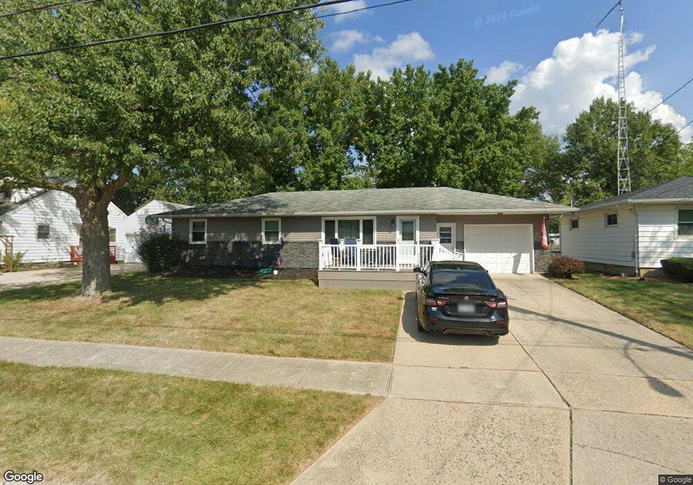
This home is located at 1112 Northwold St, Lima, OH 45801 and is currently estimated at $140,432, approximately $122 per square foot. 1112 Northwold St is a home located in Allen County with nearby schools including Independence Elementary School, Lima North Middle School, and Lima West Middle School.
Ownership History
Date
Name
Owned For
Owner Type
Purchase Details
Closed on
Feb 16, 2000
Sold by
Powers Annette L
Bought by
Collins Darnell T and Collins Cathy
Current Estimated Value
Home Financials for this Owner
Home Financials are based on the most recent Mortgage that was taken out on this home.
Original Mortgage
$74,284
Outstanding Balance
$24,556
Interest Rate
8.16%
Mortgage Type
FHA
Estimated Equity
$115,876
Purchase Details
Closed on
Jan 1, 1990
Bought by
Powers Ellis R
Create a Home Valuation Report for This Property
The Home Valuation Report is an in-depth analysis detailing your home's value as well as a comparison with similar homes in the area
Home Values in the Area
Average Home Value in this Area
Purchase History
| Date | Buyer | Sale Price | Title Company |
|---|---|---|---|
| Collins Darnell T | $74,900 | -- | |
| Powers Ellis R | -- | -- |
Source: Public Records
Mortgage History
| Date | Status | Borrower | Loan Amount |
|---|---|---|---|
| Open | Collins Darnell T | $74,284 |
Source: Public Records
Tax History Compared to Growth
Tax History
| Year | Tax Paid | Tax Assessment Tax Assessment Total Assessment is a certain percentage of the fair market value that is determined by local assessors to be the total taxable value of land and additions on the property. | Land | Improvement |
|---|---|---|---|---|
| 2024 | $1,276 | $35,220 | $5,850 | $29,370 |
| 2023 | $1,009 | $23,810 | $3,960 | $19,850 |
| 2022 | $1,014 | $23,810 | $3,960 | $19,850 |
| 2021 | $1,072 | $23,810 | $3,960 | $19,850 |
| 2020 | $1,075 | $21,210 | $3,850 | $17,360 |
| 2019 | $1,075 | $21,210 | $3,850 | $17,360 |
| 2018 | $1,059 | $21,210 | $3,850 | $17,360 |
| 2017 | $996 | $19,460 | $3,850 | $15,610 |
| 2016 | $1,004 | $19,460 | $3,850 | $15,610 |
| 2015 | $1,096 | $19,460 | $3,850 | $15,610 |
| 2014 | $1,096 | $21,140 | $3,710 | $17,430 |
| 2013 | $1,067 | $21,140 | $3,710 | $17,430 |
Source: Public Records
Map
Nearby Homes
- 849 Runyan Ave
- 676 Cortlandt Ave
- 1116 Belvidere Ave
- 765 W O'Connor Ave
- 0 Sherman Ave
- 576 Cortlandt Ave
- 648 Hazel Ave
- 638 Hazel Ave
- 631 Hazel Ave
- 608 W O'Connor Ave
- 1023 Leland Ave
- 610 W Robb Ave
- 618 Woodward Ave
- 708 N Metcalf St
- 1120 Richie Ave
- 1206 Rice Ave
- 416 Hazel Ave
- 939 N West St
- 612 N Metcalf St
- 340 W Robb Ave