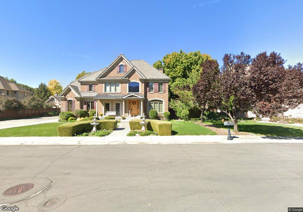
1112 S 1600 E Springville, UT 84663
East Hobble Creek NeighborhoodEstimated Value: $960,000 - $1,053,738
6
Beds
5
Baths
5,156
Sq Ft
$193/Sq Ft
Est. Value
About This Home
This home is located at 1112 S 1600 E, Springville, UT 84663 and is currently estimated at $996,913, approximately $193 per square foot. 1112 S 1600 E is a home located in Utah County with nearby schools including Sage Creek Elementary, Springville High School, and Springville Junior High School.
Ownership History
Date
Name
Owned For
Owner Type
Purchase Details
Closed on
Oct 24, 2024
Sold by
Harrop James D and Harrop Rhonda K
Bought by
James And Rhonda Harrop Family Trust and Harrop
Current Estimated Value
Purchase Details
Closed on
Oct 29, 2018
Sold by
Mark D Hall
Bought by
Harrop James and Harrop Rhonda
Home Financials for this Owner
Home Financials are based on the most recent Mortgage that was taken out on this home.
Original Mortgage
$180,000
Interest Rate
4.86%
Purchase Details
Closed on
Sep 29, 2016
Sold by
Hall Mark D
Bought by
Hall Mark D and Hall Leah M
Home Financials for this Owner
Home Financials are based on the most recent Mortgage that was taken out on this home.
Original Mortgage
$100,000
Interest Rate
3.43%
Mortgage Type
Purchase Money Mortgage
Purchase Details
Closed on
Sep 12, 2016
Sold by
Hall Mark D
Bought by
Hall Mark D and Hall Leah M
Home Financials for this Owner
Home Financials are based on the most recent Mortgage that was taken out on this home.
Original Mortgage
$100,000
Interest Rate
3.43%
Mortgage Type
Purchase Money Mortgage
Purchase Details
Closed on
Feb 13, 2007
Sold by
Paskett Chad F and Paskett Shelly E
Bought by
Prawitt Douglas F and Prawitt Meryll L
Purchase Details
Closed on
Jul 10, 2000
Sold by
Paskett Chad and Paskett Shelly
Bought by
Paskett Chad F and Paskett Shelly E
Home Financials for this Owner
Home Financials are based on the most recent Mortgage that was taken out on this home.
Original Mortgage
$344,000
Interest Rate
8.63%
Create a Home Valuation Report for This Property
The Home Valuation Report is an in-depth analysis detailing your home's value as well as a comparison with similar homes in the area
Home Values in the Area
Average Home Value in this Area
Purchase History
| Date | Buyer | Sale Price | Title Company |
|---|---|---|---|
| James And Rhonda Harrop Family Trust | -- | None Listed On Document | |
| Harrop James | -- | -- | |
| Hall Mark D | -- | Advanced Title | |
| Hall Mark D | -- | Advanced Title | |
| Hall Mark D | -- | Advanced Title | |
| Hall Mark D | -- | Advanced Title | |
| Prawitt Douglas F | -- | First American Title Pine | |
| Paskett Chad F | -- | -- |
Source: Public Records
Mortgage History
| Date | Status | Borrower | Loan Amount |
|---|---|---|---|
| Previous Owner | Harrop James | $180,000 | |
| Previous Owner | Harrop James | -- | |
| Previous Owner | Hall Mark D | $100,000 | |
| Previous Owner | Hall Mark D | $417,000 | |
| Previous Owner | Paskett Chad F | $344,000 |
Source: Public Records
Tax History
| Year | Tax Paid | Tax Assessment Tax Assessment Total Assessment is a certain percentage of the fair market value that is determined by local assessors to be the total taxable value of land and additions on the property. | Land | Improvement |
|---|---|---|---|---|
| 2025 | $4,286 | $505,175 | -- | -- |
| 2024 | $4,286 | $439,120 | $0 | $0 |
| 2023 | $4,084 | $418,825 | $0 | $0 |
| 2022 | $4,640 | $467,335 | $0 | $0 |
| 2021 | $4,088 | $640,800 | $165,900 | $474,900 |
| 2020 | $3,903 | $593,200 | $144,300 | $448,900 |
| 2019 | $3,827 | $592,200 | $144,300 | $447,900 |
| 2018 | $4,117 | $607,700 | $179,400 | $428,300 |
| 2017 | $3,826 | $299,970 | $0 | $0 |
| 2016 | $3,452 | $265,375 | $0 | $0 |
| 2015 | $3,377 | $265,375 | $0 | $0 |
| 2014 | -- | $262,350 | $0 | $0 |
Source: Public Records
Map
Nearby Homes
- 1518 E Pheasant Run Dr
- 66 E 750 S Unit 23
- 145 W Carnesecca Ct
- 557 S 1470 E
- 1884 Town And Country Rd
- 59 E 775 S Unit 21
- 52 E 775 S Unit 19
- 949 S 1060 E
- 1092 Valley Sage Dr
- 776 S 2200 E Unit 19
- 1361 E 400 S
- 1121 W 1800 N
- 1350 N Main St
- 883 E 700 S
- 1567 N 600 E Unit 26
- 1195 W 1600 N
- 715 E 1700 N
- 2554 E 350 S Unit 4
- 1052 Cove Dr
- 1062 E 350 S
- 1078 S 1600 E
- 1134 S 1600 E
- 1504 E Pheasant Run Dr
- 1512 E Pheasant Run Dr
- 1498 E Pheasant Run Dr
- 1608 E 1100 S
- 1607 E 1100 S
- 1146 S 1600 E
- 968 S 1600 E
- 1141 S 1600 E
- 1490 E Pheasant Run Dr
- 1618 E 970 S
- 1518 E 950 S
- 1503 E Pheasant Run Dr
- 1615 E 1100 S
- 1616 E 1100 S
- 1487 E Pheasant Run Dr
- 1511 E Pheasant Run Dr
- 1566 E 970 S
- 1124 S Brookwood Dr Unit 1F
Your Personal Tour Guide
Ask me questions while you tour the home.