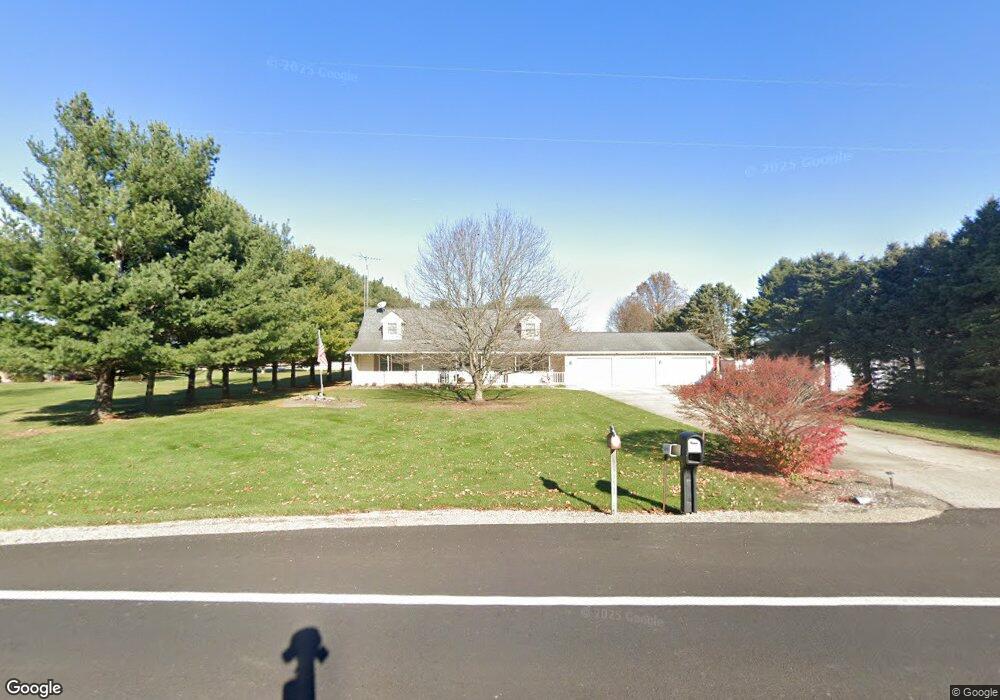
1112 W State Route 296 Urbana, OH 43078
Estimated Value: $312,000 - $467,110
3
Beds
3
Baths
2,366
Sq Ft
$161/Sq Ft
Est. Value
About This Home
This home is located at 1112 W State Route 296, Urbana, OH 43078 and is currently estimated at $382,028, approximately $161 per square foot. 1112 W State Route 296 is a home located in Champaign County with nearby schools including West Liberty-Salem Elementary School, West Liberty-Salem Middle School, and West Liberty-Salem Middle/High School.
Ownership History
Date
Name
Owned For
Owner Type
Purchase Details
Closed on
Aug 4, 2007
Sold by
Deere Ronald E and Deere Margaret M
Bought by
Phelps Michael L and Phelps Rachel E
Current Estimated Value
Purchase Details
Closed on
Aug 31, 1999
Sold by
Kimbler Virginia P
Bought by
Deere Ronald E and Deere Margaret M
Home Financials for this Owner
Home Financials are based on the most recent Mortgage that was taken out on this home.
Original Mortgage
$83,000
Interest Rate
7.61%
Mortgage Type
New Conventional
Create a Home Valuation Report for This Property
The Home Valuation Report is an in-depth analysis detailing your home's value as well as a comparison with similar homes in the area
Home Values in the Area
Average Home Value in this Area
Purchase History
| Date | Buyer | Sale Price | Title Company |
|---|---|---|---|
| Phelps Michael L | $161,000 | Attorney | |
| Deere Ronald E | $161,000 | -- |
Source: Public Records
Mortgage History
| Date | Status | Borrower | Loan Amount |
|---|---|---|---|
| Closed | Deere Ronald E | $83,000 |
Source: Public Records
Tax History Compared to Growth
Tax History
| Year | Tax Paid | Tax Assessment Tax Assessment Total Assessment is a certain percentage of the fair market value that is determined by local assessors to be the total taxable value of land and additions on the property. | Land | Improvement |
|---|---|---|---|---|
| 2024 | $3,497 | $92,690 | $8,180 | $84,510 |
| 2023 | $3,497 | $92,690 | $8,180 | $84,510 |
| 2022 | $3,509 | $92,690 | $8,180 | $84,510 |
| 2021 | $3,001 | $74,160 | $6,550 | $67,610 |
| 2020 | $3,001 | $74,160 | $6,550 | $67,610 |
| 2019 | $2,965 | $74,160 | $6,550 | $67,610 |
| 2018 | $2,474 | $62,730 | $5,890 | $56,840 |
| 2017 | $2,438 | $62,730 | $5,890 | $56,840 |
| 2016 | $2,364 | $62,730 | $5,890 | $56,840 |
| 2015 | $2,129 | $60,020 | $5,890 | $54,130 |
| 2014 | $2,131 | $60,020 | $5,890 | $54,130 |
| 2013 | $2,112 | $60,020 | $5,890 | $54,130 |
Source: Public Records
Map
Nearby Homes
- 1010 W Herr Rd
- 0 Ohio 296
- 4416 N US Highway 68
- 0 Millerstown Rd
- 00 Millerstown Rd
- 734 Emmalyn Ave
- 1324 Kennard Kingscreek Rd
- 728 N Oakland St
- 723 N Russell St
- 241 Louden St
- 242 Laurel Oak St
- 234 Laurel Oak St
- 206 Lincoln Place
- 0 Laurel Oak St Unit 225013949
- 0 Laurel Oak St Unit 1038292
- 129 Gwynne St
- 603 E Light St
- 501 Boyce St
- 1094 W State Route 296
- 1146 W State Route 296
- 1011 W State Route 296
- 1074 W State Route 296
- 1074 Ohio 296
- 1172 W State Route 296
- 1052 W State Route 296
- 1206 W State Route 296
- 1262 Ohio 296
- 1262 W State Route 296
- 1271 W State Route 296
- 1285 W State Route 296
- 911 W State Route 296
- 1355 W State Route 296
- 1355 W State Route 296
- 1333 W State Route 296
- 772 W State Route 296
- 724 W State Route 296
- 724 W State Route 296
- 1496 W State Route 296