Estimated Value: $236,273 - $314,000
3
Beds
2
Baths
1,288
Sq Ft
$214/Sq Ft
Est. Value
About This Home
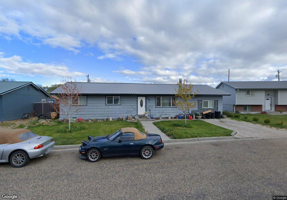
This home is located at 1113 C St W, Vale, OR 97918 and is currently estimated at $275,137, approximately $213 per square foot. 1113 C St W is a home located in Malheur County with nearby schools including Vale Middle School, Vale High School, and Mount Moriah Christian Academy.
Ownership History
Date
Name
Owned For
Owner Type
Purchase Details
Closed on
Oct 27, 2014
Sold by
Swank Lacey J and Hiatt Lacey J
Bought by
Romans Acres Llc
Current Estimated Value
Purchase Details
Closed on
Nov 20, 2007
Sold by
Wilson Margaret and Moser Colleen V
Bought by
Hiatt Lacey J
Home Financials for this Owner
Home Financials are based on the most recent Mortgage that was taken out on this home.
Original Mortgage
$70,000
Interest Rate
6.35%
Mortgage Type
New Conventional
Create a Home Valuation Report for This Property
The Home Valuation Report is an in-depth analysis detailing your home's value as well as a comparison with similar homes in the area
Home Values in the Area
Average Home Value in this Area
Purchase History
| Date | Buyer | Sale Price | Title Company |
|---|---|---|---|
| Romans Acres Llc | $89,000 | Malheur County Title Co Inc | |
| Hiatt Lacey J | $8,800 | -- |
Source: Public Records
Mortgage History
| Date | Status | Borrower | Loan Amount |
|---|---|---|---|
| Previous Owner | Hiatt Lacey J | $70,000 |
Source: Public Records
Tax History Compared to Growth
Tax History
| Year | Tax Paid | Tax Assessment Tax Assessment Total Assessment is a certain percentage of the fair market value that is determined by local assessors to be the total taxable value of land and additions on the property. | Land | Improvement |
|---|---|---|---|---|
| 2025 | $1,931 | $106,412 | $15,733 | $90,679 |
| 2024 | $1,884 | $103,313 | $15,275 | $88,038 |
| 2023 | $1,824 | $100,304 | $16,076 | $84,228 |
| 2022 | $1,774 | $97,383 | $20,186 | $77,197 |
| 2021 | $1,776 | $94,547 | $22,003 | $72,544 |
| 2020 | $1,684 | $91,794 | $17,958 | $73,836 |
| 2019 | $1,579 | $89,121 | $18,677 | $70,444 |
| 2018 | $1,487 | $86,526 | $18,276 | $68,250 |
| 2017 | $1,458 | $84,006 | $18,162 | $65,844 |
| 2016 | $1,390 | $81,560 | $17,633 | $63,927 |
| 2015 | $1,413 | $79,185 | $16,849 | $62,336 |
| 2014 | $1,406 | $76,879 | $17,294 | $59,585 |
Source: Public Records
Map
Nearby Homes
- 410 Yakima St S
- 250 Elm St N
- 351 W Main St S
- 983 South St
- 650 Ash St
- 448 Bryant St S
- 885 Airport Rd
- 555 15th St
- 749 Ritter Ave
- 233 Glenn St S
- 324 10th St N
- 951 Campbell St
- 908 Sierra St
- 911 Campbell St
- 927 Haul Rd
- 1882 Graham Blvd
- 1925 Graham Blvd
- 3961 John Day Hwy
- 1560 Lagoon Dr
- 1780 Sand Hollow Rd