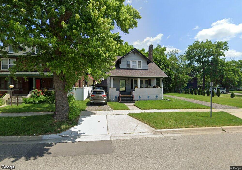
1113 Lapeer Rd Flint, MI 48503
Central Park-Fairfield Village NeighborhoodEstimated Value: $84,249 - $124,000
2
Beds
2
Baths
1,227
Sq Ft
$87/Sq Ft
Est. Value
About This Home
This home is located at 1113 Lapeer Rd, Flint, MI 48503 and is currently estimated at $106,812, approximately $87 per square foot. 1113 Lapeer Rd is a home located in Genesee County with nearby schools including Pierce Elementary School, Flint Southwestern Classical Academy, and Flint Cultural Center Academy.
Ownership History
Date
Name
Owned For
Owner Type
Purchase Details
Closed on
Apr 23, 2018
Sold by
Genesee County Land Bank Authority
Bought by
Crosby Leandre Melick
Current Estimated Value
Purchase Details
Closed on
May 27, 2005
Sold by
Reed Ora M
Bought by
Mccree Wynn D
Home Financials for this Owner
Home Financials are based on the most recent Mortgage that was taken out on this home.
Original Mortgage
$12,000
Interest Rate
5%
Mortgage Type
Seller Take Back
Create a Home Valuation Report for This Property
The Home Valuation Report is an in-depth analysis detailing your home's value as well as a comparison with similar homes in the area
Home Values in the Area
Average Home Value in this Area
Purchase History
| Date | Buyer | Sale Price | Title Company |
|---|---|---|---|
| Crosby Leandre Melick | -- | None Available | |
| Mccree Wynn D | $13,200 | -- |
Source: Public Records
Mortgage History
| Date | Status | Borrower | Loan Amount |
|---|---|---|---|
| Previous Owner | Mccree Wynn D | $12,000 |
Source: Public Records
Tax History Compared to Growth
Tax History
| Year | Tax Paid | Tax Assessment Tax Assessment Total Assessment is a certain percentage of the fair market value that is determined by local assessors to be the total taxable value of land and additions on the property. | Land | Improvement |
|---|---|---|---|---|
| 2025 | $923 | $31,000 | $0 | $0 |
| 2024 | $838 | $22,100 | $0 | $0 |
| 2023 | $825 | $17,500 | $0 | $0 |
| 2022 | $0 | $14,800 | $0 | $0 |
| 2021 | $856 | $11,700 | $0 | $0 |
| 2020 | $774 | $11,300 | $0 | $0 |
| 2019 | $1,113 | $10,500 | $0 | $0 |
| 2018 | $815 | $11,500 | $0 | $0 |
| 2017 | $820 | $0 | $0 | $0 |
| 2016 | $814 | $0 | $0 | $0 |
| 2015 | -- | $0 | $0 | $0 |
| 2014 | -- | $0 | $0 | $0 |
| 2012 | -- | $17,800 | $0 | $0 |
Source: Public Records
Map
Nearby Homes
- 841 E 8th St
- 911 E 7th St
- 903 E Court St
- 915 E Court St Unit 104
- 915 E Court St
- 915 E Court #206 St Unit 206
- 410 E 4th St
- 621 Pierson St
- 607 East St
- 620 E 2nd St
- A Avenue
- 211 W 5th St
- 420 Pingree Ave
- 1623 Montclair Ave
- 1510 S Franklin Ave
- 1215 S Grand Traverse St
- 1114 S Grand Traverse St
- 1009 Oak St
- 2010 Crocker Ave
- 1018 Lafayette St