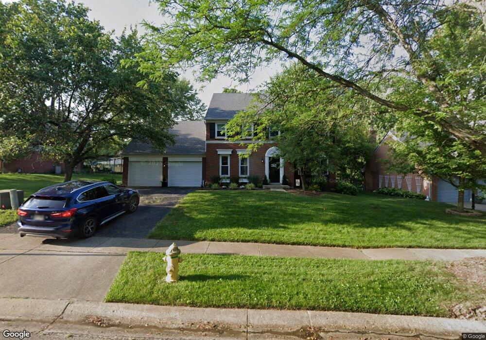
11130 Allenhurst Blvd E Cincinnati, OH 45241
Estimated Value: $461,000 - $669,000
4
Beds
3
Baths
2,724
Sq Ft
$194/Sq Ft
Est. Value
About This Home
This home is located at 11130 Allenhurst Blvd E, Cincinnati, OH 45241 and is currently estimated at $527,352, approximately $193 per square foot. 11130 Allenhurst Blvd E is a home located in Hamilton County with nearby schools including Sharonville Elementary School, Princeton Community Middle School, and Princeton High School.
Ownership History
Date
Name
Owned For
Owner Type
Purchase Details
Closed on
Feb 12, 2004
Sold by
Simmons Paul A and Simmons Mary E
Bought by
Alvord Matthew J and Alvord Jamie M
Current Estimated Value
Home Financials for this Owner
Home Financials are based on the most recent Mortgage that was taken out on this home.
Original Mortgage
$184,000
Interest Rate
5.77%
Mortgage Type
Unknown
Create a Home Valuation Report for This Property
The Home Valuation Report is an in-depth analysis detailing your home's value as well as a comparison with similar homes in the area
Home Values in the Area
Average Home Value in this Area
Purchase History
| Date | Buyer | Sale Price | Title Company |
|---|---|---|---|
| Alvord Matthew J | $230,000 | -- |
Source: Public Records
Mortgage History
| Date | Status | Borrower | Loan Amount |
|---|---|---|---|
| Closed | Alvord Matthew J | $184,000 | |
| Closed | Alvord Matthew J | $46,000 |
Source: Public Records
Tax History
| Year | Tax Paid | Tax Assessment Tax Assessment Total Assessment is a certain percentage of the fair market value that is determined by local assessors to be the total taxable value of land and additions on the property. | Land | Improvement |
|---|---|---|---|---|
| 2025 | $5,495 | $115,563 | $19,075 | $96,488 |
| 2023 | $4,694 | $115,563 | $19,075 | $96,488 |
| 2022 | $4,525 | $89,516 | $18,886 | $70,630 |
| 2021 | $4,398 | $89,516 | $18,886 | $70,630 |
| 2020 | $4,450 | $89,516 | $18,886 | $70,630 |
| 2019 | $4,438 | $82,124 | $17,325 | $64,799 |
| 2018 | $4,163 | $82,124 | $17,325 | $64,799 |
| 2017 | $3,898 | $82,124 | $17,325 | $64,799 |
| 2016 | $4,253 | $88,887 | $16,853 | $72,034 |
| 2015 | $4,294 | $88,887 | $16,853 | $72,034 |
| 2014 | $4,309 | $88,887 | $16,853 | $72,034 |
| 2013 | $3,934 | $83,073 | $15,750 | $67,323 |
Source: Public Records
Map
Nearby Homes
- 4170 Cornell Rd
- 4036 Haverstraw Dr
- 11108 Huntwicke Place
- 4365 Classic Dr
- 3963 Malaer Dr
- 11133 Jardin Place
- 11143 Jardin Place
- 3929 Malaer Dr
- 4159 Sweetgum Ct
- 11190 Lebanon Ave
- 4254 Fox Hollow Dr
- 5930 Carpol St
- 4195 Crystal View Ct
- 3319 Mcgrew St
- 3875 Hauck Rd
- 11990 Thames Place
- 5164 Londonderry Dr
- 3590 Glendale Milford Rd
- 10301 Giverny Blvd
- 10561 Plainfield Rd
- 11124 Allenhurst Blvd E
- 11136 Allenhurst Blvd E
- 4181 Cornell Rd
- 11118 Allenhurst Blvd E
- 11125 Allenhurst Blvd E
- 4169 Cornell Rd
- 11131 Allenhurst Blvd E
- 11119 Allenhurst Blvd E
- 11113 Allenhurst Blvd E
- 4156 Allenhurst Close
- 11110 Zaring Ct
- 11104 Zaring Ct
- 4209 Cornell Rd
- 11107 Allenhurst Blvd E
- 4162 Allenhurst Close
- 11111 Zaring Ct
- 11098 Zaring Ct
- 11135 Allenhurst Blvd W
- 4162 Allenhurst Close Ct
- 4143 Cornell Rd
Your Personal Tour Guide
Ask me questions while you tour the home.