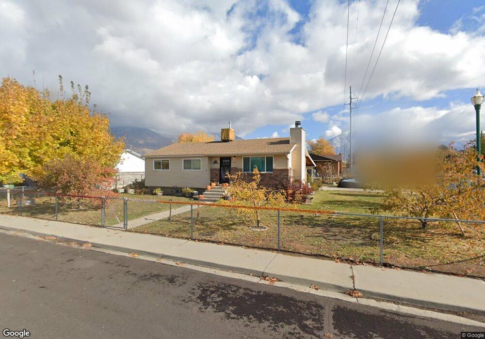
1114 N 950 W Orem, UT 84057
Bonneville NeighborhoodEstimated Value: $486,000 - $493,366
5
Beds
2
Baths
2,205
Sq Ft
$222/Sq Ft
Est. Value
About This Home
This home is located at 1114 N 950 W, Orem, UT 84057 and is currently estimated at $490,122, approximately $222 per square foot. 1114 N 950 W is a home located in Utah County with nearby schools including Bonneville Elementary School, Orem Junior High School, and Timpanogos High School.
Ownership History
Date
Name
Owned For
Owner Type
Purchase Details
Closed on
May 7, 2010
Sold by
Beck Joseph Paul and Beck Andrea Whitchurch
Bought by
Keller Jared L and Keller Laurel A
Current Estimated Value
Purchase Details
Closed on
Aug 27, 2004
Sold by
Corporation Of The Presiding Bishop Of T
Bought by
Beck Ii Joseph Paul and Beck Andrea Whitchurch
Purchase Details
Closed on
Jun 26, 2001
Sold by
Corporation Of The Presiding Bishop Of T
Bought by
Tedbac Llc
Purchase Details
Closed on
Dec 21, 2000
Sold by
Clear Horizons Ltd Partnership
Bought by
The Corporation Of The Presiding Bishop
Create a Home Valuation Report for This Property
The Home Valuation Report is an in-depth analysis detailing your home's value as well as a comparison with similar homes in the area
Home Values in the Area
Average Home Value in this Area
Purchase History
| Date | Buyer | Sale Price | Title Company |
|---|---|---|---|
| Keller Jared L | -- | Eagle Pointe Title Insuranc | |
| Beck Ii Joseph Paul | -- | Bartlett Title Insurance Ag | |
| Tedbac Llc | -- | Century Title | |
| The Corporation Of The Presiding Bishop | -- | Century Title |
Source: Public Records
Tax History
| Year | Tax Paid | Tax Assessment Tax Assessment Total Assessment is a certain percentage of the fair market value that is determined by local assessors to be the total taxable value of land and additions on the property. | Land | Improvement |
|---|---|---|---|---|
| 2025 | $1,859 | $236,830 | -- | -- |
| 2024 | $1,859 | $227,260 | $0 | $0 |
| 2023 | $1,720 | $226,050 | $0 | $0 |
| 2022 | $1,714 | $218,240 | $0 | $0 |
| 2021 | $1,595 | $307,600 | $153,500 | $154,100 |
| 2020 | $1,445 | $273,900 | $122,800 | $151,100 |
| 2019 | $1,334 | $263,000 | $122,800 | $140,200 |
| 2018 | $1,305 | $245,800 | $112,300 | $133,500 |
| 2017 | $1,251 | $126,170 | $0 | $0 |
| 2016 | $1,233 | $114,675 | $0 | $0 |
| 2015 | $1,188 | $104,500 | $0 | $0 |
| 2014 | $1,114 | $97,570 | $0 | $0 |
Source: Public Records
Map
Nearby Homes
- 999 W 1100 N
- 1123 N 800 W
- 1062 N 1035 W
- 930 N 980 W
- 1069 N 1160 W
- 1140 W 950 N Unit D302
- 1140 W 950 N Unit D304
- 1140 W 950 N Unit A401
- 1405 N 770 W
- 538 W 1120 N
- 545 W 1240 N
- 582 W 1300 N
- 1535 N 950 W
- 531 W 1350 N
- 686 N 835 W
- 1167 W 1550 N
- 1499 N 1200 W Unit 8
- 954 W 630 N Unit 34,
- 967 W 1630 N
- 1545 N State St Unit 1
Your Personal Tour Guide
Ask me questions while you tour the home.