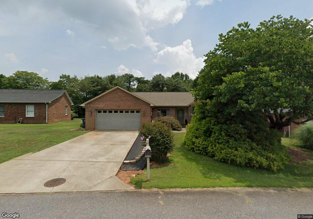
1114 St Michaels Dr SE Conover, NC 28613
Estimated Value: $256,667 - $300,000
3
Beds
2
Baths
1,248
Sq Ft
$217/Sq Ft
Est. Value
About This Home
This home is located at 1114 St Michaels Dr SE, Conover, NC 28613 and is currently estimated at $270,417, approximately $216 per square foot. 1114 St Michaels Dr SE is a home located in Catawba County with nearby schools including North Newton Elementary School, Newton-Conover Middle School, and Newton-Conover High School.
Ownership History
Date
Name
Owned For
Owner Type
Purchase Details
Closed on
Jun 30, 2008
Sold by
Farmer Alisa D and Ramirez Saul
Bought by
Marlow Thomas Keith
Current Estimated Value
Home Financials for this Owner
Home Financials are based on the most recent Mortgage that was taken out on this home.
Original Mortgage
$116,000
Outstanding Balance
$74,455
Interest Rate
5.97%
Mortgage Type
Purchase Money Mortgage
Estimated Equity
$195,962
Create a Home Valuation Report for This Property
The Home Valuation Report is an in-depth analysis detailing your home's value as well as a comparison with similar homes in the area
Home Values in the Area
Average Home Value in this Area
Purchase History
| Date | Buyer | Sale Price | Title Company |
|---|---|---|---|
| Marlow Thomas Keith | $126,000 | None Available |
Source: Public Records
Mortgage History
| Date | Status | Borrower | Loan Amount |
|---|---|---|---|
| Open | Marlow Thomas Keith | $116,000 |
Source: Public Records
Tax History Compared to Growth
Tax History
| Year | Tax Paid | Tax Assessment Tax Assessment Total Assessment is a certain percentage of the fair market value that is determined by local assessors to be the total taxable value of land and additions on the property. | Land | Improvement |
|---|---|---|---|---|
| 2025 | $1,687 | $212,600 | $9,700 | $202,900 |
| 2024 | $1,687 | $212,600 | $9,700 | $202,900 |
| 2023 | $1,687 | $212,600 | $9,700 | $202,900 |
| 2022 | $1,449 | $134,800 | $9,700 | $125,100 |
| 2021 | $1,449 | $134,800 | $9,700 | $125,100 |
| 2020 | $1,449 | $134,800 | $9,700 | $125,100 |
| 2019 | $1,449 | $134,800 | $0 | $0 |
| 2018 | $1,271 | $118,200 | $10,800 | $107,400 |
| 2017 | $1,235 | $0 | $0 | $0 |
| 2016 | $1,235 | $0 | $0 | $0 |
| 2015 | $1,106 | $118,200 | $10,800 | $107,400 |
| 2014 | $1,106 | $118,900 | $11,500 | $107,400 |
Source: Public Records
Map
Nearby Homes
- 1106 3rd Street Dr SE
- 111 6th Ave NE
- 505 2nd Street Place NE Unit U1
- 811 4th St NE
- 1605 3rd St NE
- 304 Parlier Ave NE
- 507 6th Ave NE
- 2901 N Shipp Ave
- 814 2nd Ave SW
- 502 3rd Ave NE
- 510 4th Ave NE
- 2075 N Whisnant Ave
- 319 7th Street Place SW Unit B1
- 510 7th St NE
- 221 5th St NE
- 312 2nd Ave NE
- 0000 Burris Rd
- 2661 N Ashe Ave
- 112 W 23rd St
- 2655 N Ashe Ave
- 1116 St Michaels Dr SE
- 1112 St Michaels Dr SE
- 1110 St Michaels Dr SE
- 1113 St Michaels Dr SE
- 1118 St Michaels Dr SE
- 1007 Beacons Dr SE
- 1117 St Michaels Dr SE
- 1108 St Michaels Dr SE
- 1005 Beacons Dr SE
- 1105 Daffodil Ct SE
- 1106 St Michaels Dr SE
- 1003 Beacons Dr SE
- 1008 Beacons Dr SE
- 1006 Beacons Dr SE
- 1107 Daffodil Ct SE
- 1004 Beacons Dr SE
- 1111 1st Street Place SE
- 1104 St Michaels Dr SE
- 1200 Emmanuel Church Rd
- 1106 1st Street Place SE