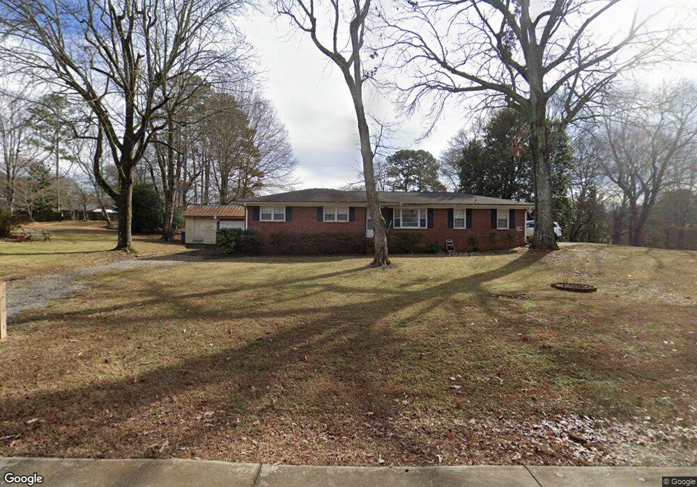
1115 Roberts Dr Sugar Hill, GA 30518
Estimated Value: $300,853 - $341,000
3
Beds
2
Baths
1,134
Sq Ft
$284/Sq Ft
Est. Value
About This Home
This home is located at 1115 Roberts Dr, Sugar Hill, GA 30518 and is currently estimated at $322,463, approximately $284 per square foot. 1115 Roberts Dr is a home located in Gwinnett County with nearby schools including Sugar Hill Elementary School, Lanier Middle School, and Lanier High School.
Ownership History
Date
Name
Owned For
Owner Type
Purchase Details
Closed on
Mar 31, 2025
Sold by
Clay Mary Jane
Bought by
Clay Mary Jane Trust and Clay Mary Jane
Current Estimated Value
Purchase Details
Closed on
May 26, 2011
Sold by
Clay Richard A
Bought by
Clay Mary J
Purchase Details
Closed on
Aug 18, 2001
Sold by
Clay Richard
Bought by
Clay Richard A and Clay Mary J
Home Financials for this Owner
Home Financials are based on the most recent Mortgage that was taken out on this home.
Original Mortgage
$135,000
Interest Rate
7.08%
Mortgage Type
New Conventional
Create a Home Valuation Report for This Property
The Home Valuation Report is an in-depth analysis detailing your home's value as well as a comparison with similar homes in the area
Home Values in the Area
Average Home Value in this Area
Purchase History
| Date | Buyer | Sale Price | Title Company |
|---|---|---|---|
| Clay Mary Jane Trust | -- | -- | |
| Clay Mary J | -- | -- | |
| Clay Richard A | -- | -- |
Source: Public Records
Mortgage History
| Date | Status | Borrower | Loan Amount |
|---|---|---|---|
| Previous Owner | Clay Richard A | $135,000 |
Source: Public Records
Tax History Compared to Growth
Tax History
| Year | Tax Paid | Tax Assessment Tax Assessment Total Assessment is a certain percentage of the fair market value that is determined by local assessors to be the total taxable value of land and additions on the property. | Land | Improvement |
|---|---|---|---|---|
| 2024 | $221 | $87,720 | $28,000 | $59,720 |
| 2023 | $221 | $79,920 | $22,000 | $57,920 |
| 2022 | $221 | $79,920 | $22,000 | $57,920 |
| 2021 | $221 | $50,720 | $15,200 | $35,520 |
| 2020 | $470 | $50,720 | $15,200 | $35,520 |
| 2019 | $449 | $50,720 | $15,200 | $35,520 |
| 2018 | $438 | $47,920 | $12,000 | $35,920 |
| 2016 | $416 | $42,080 | $12,000 | $30,080 |
| 2015 | $376 | $30,000 | $7,600 | $22,400 |
| 2014 | -- | $30,000 | $7,600 | $22,400 |
Source: Public Records
Map
Nearby Homes
- 1402 Frontier Dr
- 4567 Duncan Dr
- 4485 Forest Green Dr
- 887 Woods Chapel Rd
- 4648 Pine Tree Cir Unit B
- 4648 Pine Tree # B Cir
- 1398 Pine Acre Dr
- 1092 Owen Cir
- 1477 Lanier Vista Dr
- 1417 Lanier Vista Dr
- 1078 Pine Acre Dr
- 4687 Riley Run Ct Unit 1
- 1286 Lanier Vista Dr
- 4225 Hidden Meadow Cir
- The Murphy Plan at White Street
- 4862 White St
- 155 Westbrook St NE
- 4360 Lanier Park Dr
- 4628 McEver View Dr
- 1105 Roberts Dr
- 1329 Wansley Ln
- 1135 W Roberts Dr
- 1135 Roberts Dr
- 1318 Wansley Ln
- 0 Wansley Ln
- 1124 Roberts Dr
- 1114 Roberts Dr
- 1095 Roberts Dr
- 1324 Sherri Ln
- 1134 Roberts Dr
- 1349 Wansley Ln Unit 1
- 1094 Roberts Dr
- 1334 Sherri Ln
- 2220 Buford Town Dr
- 2210 Buford Town Dr
- 934 Thrope Ln
- 2353 Buford Town Dr Unit 2353
- 2323 Buford Town Dr
- 924 Thrope Ln