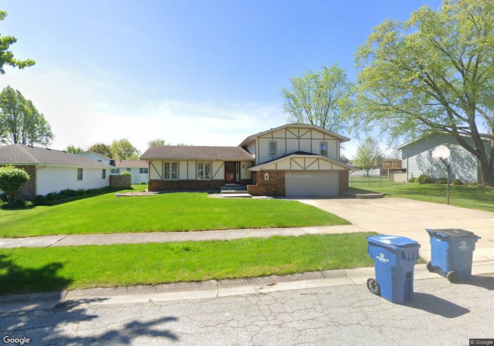
1115 Sioux Dr Crown Point, IN 46307
Estimated Value: $340,000 - $399,000
3
Beds
3
Baths
2,046
Sq Ft
$183/Sq Ft
Est. Value
About This Home
This home is located at 1115 Sioux Dr, Crown Point, IN 46307 and is currently estimated at $373,602, approximately $182 per square foot. 1115 Sioux Dr is a home located in Lake County with nearby schools including Solon Robinson Elementary School, Colonel John Wheeler Middle School, and Crown Point High School.
Ownership History
Date
Name
Owned For
Owner Type
Purchase Details
Closed on
Feb 11, 2013
Sold by
Keith William S and Keith Lori A
Bought by
Lighthouse Property Group Llc
Current Estimated Value
Purchase Details
Closed on
May 3, 2011
Sold by
Federal Home Loan Mortgage Corporation
Bought by
Keith William S and Keith Lori A
Purchase Details
Closed on
Jun 4, 2010
Sold by
Mitchell Julea Y
Bought by
Federal Home Loan Mortgage Corp
Purchase Details
Closed on
Oct 10, 2005
Sold by
Hein F David F and Hein Margaret A
Bought by
Mitchell Julea
Home Financials for this Owner
Home Financials are based on the most recent Mortgage that was taken out on this home.
Original Mortgage
$180,000
Interest Rate
5.82%
Mortgage Type
Fannie Mae Freddie Mac
Create a Home Valuation Report for This Property
The Home Valuation Report is an in-depth analysis detailing your home's value as well as a comparison with similar homes in the area
Home Values in the Area
Average Home Value in this Area
Purchase History
| Date | Buyer | Sale Price | Title Company |
|---|---|---|---|
| Lighthouse Property Group Llc | -- | None Available | |
| Keith William S | -- | Statewide Title Company Inc | |
| Federal Home Loan Mortgage Corp | $183,851 | None Available | |
| Mitchell Julea | -- | Chicago Title Insurance Comp |
Source: Public Records
Mortgage History
| Date | Status | Borrower | Loan Amount |
|---|---|---|---|
| Previous Owner | Mitchell Julea | $180,000 |
Source: Public Records
Tax History
| Year | Tax Paid | Tax Assessment Tax Assessment Total Assessment is a certain percentage of the fair market value that is determined by local assessors to be the total taxable value of land and additions on the property. | Land | Improvement |
|---|---|---|---|---|
| 2025 | $5,810 | $321,800 | $45,100 | $276,700 |
| 2024 | $7,182 | $295,500 | $45,100 | $250,400 |
| 2023 | $5,538 | $261,300 | $39,200 | $222,100 |
| 2022 | $5,538 | $250,600 | $39,200 | $211,400 |
| 2021 | $5,315 | $240,500 | $33,400 | $207,100 |
| 2020 | $5,227 | $236,500 | $33,400 | $203,100 |
| 2019 | $5,084 | $228,000 | $33,400 | $194,600 |
| 2018 | $5,605 | $218,200 | $33,400 | $184,800 |
| 2017 | $5,321 | $204,500 | $33,400 | $171,100 |
| 2016 | $5,194 | $196,100 | $33,400 | $162,700 |
| 2014 | $4,657 | $187,400 | $33,400 | $154,000 |
| 2013 | $4,614 | $183,500 | $33,400 | $150,100 |
Source: Public Records
Map
Nearby Homes
- 1150 Greenview Place
- 943 Pawnee Dr
- 991 Greenview Dr
- 206 U S 231
- 1285 Greenview Place
- 1191 Churchill Ln
- 622 E Brookside Dr
- 11742 Broadway
- 11664 Broadway
- 11828 Broadway
- 11610 Broadway
- 347 Sawgrass Dr
- 10330 Privet Dr
- 319 Michele Ave
- 13131 Rutledge Place
- 1838 Golden Oak Ct
- 254 E Greenwood Ave
- 741 Pettibone St
- 10377 Nevada Ct
- 228 Wood St
- 1121 Sioux Dr
- 1101 Sioux Dr
- 1130 Seminole Dr
- 1127 Sioux Dr
- 1140 Seminole Dr
- 1110 Sioux Dr
- 1116 Sioux Dr
- 748 Trenton St
- 1150 Seminole Dr
- 1122 Sioux Dr
- 1133 Sioux Dr
- 721 Trenton St
- 727 Trenton St
- 1160 Seminole Dr
- 754 Trenton St
- 1128 Sioux Dr
- 1111 E Greenwood Ave
- 1117 E Greenwood Ave
- 1205 Sioux Dr
- 733 Trenton St
Your Personal Tour Guide
Ask me questions while you tour the home.