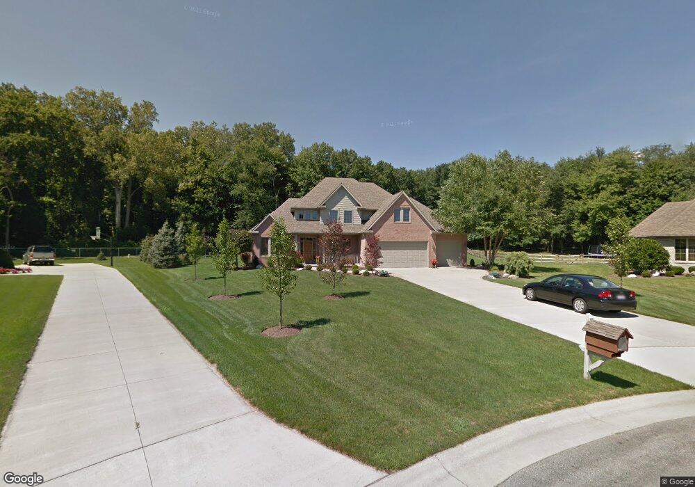
11152 Oak Pointe Dr Whitehouse, OH 43571
West Lucas County NeighborhoodEstimated Value: $538,000 - $607,000
4
Beds
4
Baths
3,459
Sq Ft
$167/Sq Ft
Est. Value
About This Home
This home is located at 11152 Oak Pointe Dr, Whitehouse, OH 43571 and is currently estimated at $577,462, approximately $166 per square foot. 11152 Oak Pointe Dr is a home located in Lucas County with nearby schools including Anthony Wayne High School and Lial Catholic School.
Ownership History
Date
Name
Owned For
Owner Type
Purchase Details
Closed on
Nov 23, 2021
Sold by
Hoyt Robert R and Hoyt Tonya L
Bought by
Hoyt Robert R and Hoyt Tonya L
Current Estimated Value
Purchase Details
Closed on
Apr 4, 2003
Sold by
Hanifan Obenauf Builders Inc
Bought by
Hoyt Robert R and Hoyt Tonya L
Home Financials for this Owner
Home Financials are based on the most recent Mortgage that was taken out on this home.
Original Mortgage
$267,200
Outstanding Balance
$121,654
Interest Rate
5.94%
Estimated Equity
$455,808
Create a Home Valuation Report for This Property
The Home Valuation Report is an in-depth analysis detailing your home's value as well as a comparison with similar homes in the area
Home Values in the Area
Average Home Value in this Area
Purchase History
| Date | Buyer | Sale Price | Title Company |
|---|---|---|---|
| Hoyt Robert R | -- | None Available | |
| Hoyt Robert R | $75,000 | -- |
Source: Public Records
Mortgage History
| Date | Status | Borrower | Loan Amount |
|---|---|---|---|
| Open | Hoyt Robert R | $267,200 |
Source: Public Records
Tax History Compared to Growth
Tax History
| Year | Tax Paid | Tax Assessment Tax Assessment Total Assessment is a certain percentage of the fair market value that is determined by local assessors to be the total taxable value of land and additions on the property. | Land | Improvement |
|---|---|---|---|---|
| 2024 | $4,117 | $167,720 | $23,835 | $143,885 |
| 2023 | $6,827 | $125,580 | $21,035 | $104,545 |
| 2022 | $6,892 | $125,580 | $21,035 | $104,545 |
| 2021 | $6,947 | $125,580 | $21,035 | $104,545 |
| 2020 | $6,608 | $106,890 | $17,885 | $89,005 |
| 2019 | $6,067 | $106,890 | $17,885 | $89,005 |
| 2018 | $5,827 | $106,890 | $17,885 | $89,005 |
| 2017 | $5,977 | $98,245 | $20,930 | $77,315 |
| 2016 | $5,914 | $280,700 | $59,800 | $220,900 |
| 2015 | $5,647 | $280,700 | $59,800 | $220,900 |
| 2014 | $5,691 | $97,270 | $20,720 | $76,550 |
| 2013 | $5,691 | $97,270 | $20,720 | $76,550 |
Source: Public Records
Map
Nearby Homes
- 5935 Lynwood Ct
- 6414 Lenderson Ave
- 10751 Brexton Ct
- 10700 Brexton Ct
- 10706 Brexton Ct
- 10701 Brexton Ct
- 6306 Weckerly Rd
- 6715 Oakbrook Dr
- 6547 Lenderson Ave
- 11149 West St
- 0 Lot 37 Savanna Lake Blvd
- 0 Lot 36 Savanna Lake Blvd
- 0 Lot 35 Savanna Lake Blvd
- 0 Lot 34 Savanna Lake Blvd
- 6746 Oak Crossing Ln
- 6935 Big Buck Trail
- 6951 Red Stag Ct
- 6952 Red Stag Ct
- 11158 Whitetail Way
- 7008 Queensmark Ln
- 11142 Oak Pointe Dr
- 11153 Oak Pointe Dr
- 11132 Oak Pointe Dr
- 11143 Oak Pointe Dr
- 6018 Kirtland Ln
- 6004 Kirtland Ln
- 11133 Oak Pointe Dr
- 11139 Birch Pointe Dr
- 11123 Oak Pointe Dr
- 11113 Oak Pointe Dr
- 5943 Lynwood Ct
- 11125 Birch Pointe Dr
- 6017 Kirtland Ln
- 5923 Lynwood Ct
- 11103 Oak Pointe Dr
- 10 Preserve Blvd
- 5951 Lynwood Ct
- 6003 Kirtland Ln
- 11060 Oak Pointe Dr
- 11101 Birch Pointe Dr