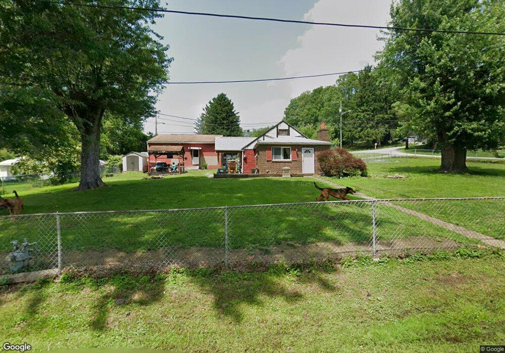
1117 Armstrong Ave Vandergrift, PA 15690
Parks Township NeighborhoodEstimated Value: $97,000 - $181,000
2
Beds
1
Bath
1,206
Sq Ft
$121/Sq Ft
Est. Value
About This Home
This home is located at 1117 Armstrong Ave, Vandergrift, PA 15690 and is currently estimated at $146,083, approximately $121 per square foot. 1117 Armstrong Ave is a home with nearby schools including Kiski Area High School.
Ownership History
Date
Name
Owned For
Owner Type
Purchase Details
Closed on
Mar 20, 2024
Sold by
Helm R
Bought by
Hoculock Chadwick
Current Estimated Value
Purchase Details
Closed on
Nov 10, 2017
Sold by
Elliott Brandon M
Bought by
Helm Roxanne Renee
Home Financials for this Owner
Home Financials are based on the most recent Mortgage that was taken out on this home.
Original Mortgage
$67,676
Interest Rate
3.94%
Mortgage Type
New Conventional
Purchase Details
Closed on
Jul 23, 2007
Sold by
Stevens Clair W and Stevens Beverly J
Bought by
Elliott Brandon M
Home Financials for this Owner
Home Financials are based on the most recent Mortgage that was taken out on this home.
Original Mortgage
$64,950
Interest Rate
6.67%
Mortgage Type
FHA
Purchase Details
Closed on
Oct 12, 1990
Create a Home Valuation Report for This Property
The Home Valuation Report is an in-depth analysis detailing your home's value as well as a comparison with similar homes in the area
Home Values in the Area
Average Home Value in this Area
Purchase History
| Date | Buyer | Sale Price | Title Company |
|---|---|---|---|
| Hoculock Chadwick | -- | None Listed On Document | |
| Helm Roxanne Renee | $67,000 | None Available | |
| Elliott Brandon M | $65,500 | None Available | |
| -- | $47,000 | -- |
Source: Public Records
Mortgage History
| Date | Status | Borrower | Loan Amount |
|---|---|---|---|
| Previous Owner | Helm Roxanne Renee | $67,676 | |
| Previous Owner | Elliott Brandon M | $64,950 |
Source: Public Records
Tax History Compared to Growth
Tax History
| Year | Tax Paid | Tax Assessment Tax Assessment Total Assessment is a certain percentage of the fair market value that is determined by local assessors to be the total taxable value of land and additions on the property. | Land | Improvement |
|---|---|---|---|---|
| 2025 | $2,393 | $32,140 | $18,250 | $13,890 |
| 2024 | $2,211 | $32,140 | $18,250 | $13,890 |
| 2023 | $1,861 | $32,140 | $18,250 | $13,890 |
| 2022 | $1,861 | $32,140 | $18,250 | $13,890 |
| 2021 | $1,859 | $32,140 | $18,250 | $13,890 |
| 2020 | $1,883 | $32,140 | $18,250 | $13,890 |
| 2019 | $1,881 | $32,140 | $18,250 | $13,890 |
| 2018 | $1,844 | $26,070 | $6,230 | $19,840 |
| 2017 | $1,802 | $32,140 | $18,250 | $13,890 |
| 2016 | $1,750 | $32,140 | $18,250 | $13,890 |
| 2015 | $1,600 | $32,140 | $18,250 | $13,890 |
| 2014 | $1,600 | $32,140 | $18,250 | $13,890 |
Source: Public Records
Map
Nearby Homes
- 1252 Jefferson St
- 133 Sherman Ave
- 137 Sherman Ave
- 112 Farragut Ave Unit 3
- 109 Washington Ave
- 2632 River Rd
- 109 E Adams Ave
- 311 Elm St
- 1116 Grant St
- 154 Jefferson Ave Unit 6
- 121 Hamilton Ave
- 315 Spruce St
- 247 Sherman Ave
- 314 Linden St
- 404 1/2 Franklin Ave
- 517 Sycamore St
- 323 Sycamore St
- 129 Franklin Ave
- 219 Quay St
- 533A Walnut St
- 1113 Armstrong Ave
- 1101 Elk Ave
- 1108 Marshall St
- 1109 Armstrong Ave
- 1103 Elk Ave
- 1117 Clarion Ave
- 1107 Elk Ave
- 1110 Cell Tower Rd
- 1107 Armstrong Ave
- 1121 Clarion Ave
- 1115 Clarion Ave
- 1125 Clarion Ave
- 1129 Clarion Ave
- 1106 Armstrong Ave
- 1109 Elk Ave
- 1114 Cell Tower Rd
- 1111 Clarion Ave
- 1103 Armstrong Ave
- 1117 Cell Tower Rd
- 1117 Cell Tower Rd