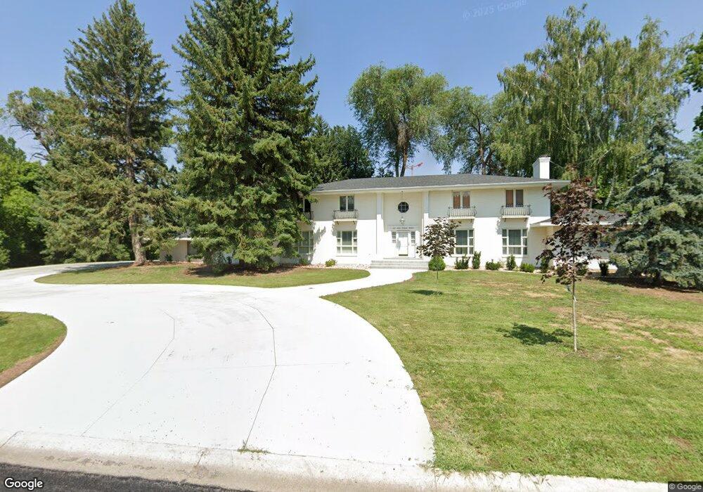
1117 Fox Farm Rd Logan, UT 84321
Wilson NeighborhoodEstimated Value: $991,000 - $1,276,307
6
Beds
5
Baths
7,567
Sq Ft
$150/Sq Ft
Est. Value
About This Home
This home is located at 1117 Fox Farm Rd, Logan, UT 84321 and is currently estimated at $1,132,327, approximately $149 per square foot. 1117 Fox Farm Rd is a home located in Cache County with nearby schools including Wilson School, Mount Logan Middle School, and Logan High School.
Ownership History
Date
Name
Owned For
Owner Type
Purchase Details
Closed on
May 7, 2013
Sold by
West Martha S and West Stephen A
Bought by
Bessinger David E and Bessinger Sheryl S
Current Estimated Value
Purchase Details
Closed on
Jan 17, 2012
Sold by
West Martha S and West Stephen A
Bought by
Isom Casey Nathan and Isom Jennifer Dawn Chenn
Home Financials for this Owner
Home Financials are based on the most recent Mortgage that was taken out on this home.
Original Mortgage
$50,000
Interest Rate
3.93%
Mortgage Type
Future Advance Clause Open End Mortgage
Create a Home Valuation Report for This Property
The Home Valuation Report is an in-depth analysis detailing your home's value as well as a comparison with similar homes in the area
Home Values in the Area
Average Home Value in this Area
Purchase History
| Date | Buyer | Sale Price | Title Company |
|---|---|---|---|
| Bessinger David E | -- | Hickman Land Title Company | |
| Isom Casey Nathan | -- | Cache Title Company |
Source: Public Records
Mortgage History
| Date | Status | Borrower | Loan Amount |
|---|---|---|---|
| Previous Owner | Isom Casey Nathan | $50,000 |
Source: Public Records
Tax History Compared to Growth
Tax History
| Year | Tax Paid | Tax Assessment Tax Assessment Total Assessment is a certain percentage of the fair market value that is determined by local assessors to be the total taxable value of land and additions on the property. | Land | Improvement |
|---|---|---|---|---|
| 2025 | $5,643 | $729,865 | $0 | $0 |
| 2024 | $5,827 | $729,865 | $0 | $0 |
| 2023 | $6,088 | $726,935 | $0 | $0 |
| 2022 | $5,880 | $655,570 | $0 | $0 |
| 2021 | $5,506 | $948,370 | $136,450 | $811,920 |
| 2020 | $5,245 | $813,050 | $136,450 | $676,600 |
| 2019 | $5,479 | $812,632 | $136,450 | $676,182 |
| 2018 | $5,239 | $709,486 | $136,450 | $573,036 |
| 2017 | $4,935 | $353,350 | $0 | $0 |
| 2016 | $5,117 | $353,350 | $0 | $0 |
| 2015 | $5,122 | $353,350 | $0 | $0 |
| 2014 | $4,622 | $352,685 | $0 | $0 |
| 2013 | -- | $641,245 | $0 | $0 |
Source: Public Records
Map
Nearby Homes
- 1045 Fox Farm Rd
- 1034 Thrushwood Dr
- 1387 E 260 N
- 1374 E 260 N
- 10 S 1300 E
- 240 N 1480 E
- 128 S 1170 E
- 28 River Pointe Dr
- 684 Apple Dr
- 820 Hillcrest Ave
- 1279 Eastridge Dr
- 661 E 600 N
- 631 E 600 N
- 567 E 200 N
- 642 E 700 N
- 1605 Mountain Rd
- 45 River Circle Dr
- 147 Winding Way Unit 50
- 159 Winding Way Unit 49
- 1393 Davis Ave
- 1125 Fox Farm Rd
- 1120 Fox Farm Rd
- 1102 Fox Farm Rd
- 1137 Fox Farm Rd
- 1130 Fox Farm Rd
- 1092 Fox Farm Rd
- 1066 Canyon Rd
- 1165 Fox Farm Rd
- 1147 Sumac Dr
- 1077 Fox Farm Rd
- 1141 Fox Farm Rd
- 1150 Fox Farm Rd
- 1143 Sumac Dr
- 1155 Sumac Dr
- 1160 Fox Farm Rd
- 380 Lauralin Dr
- 372 Lauralin Dr
- 384 Lauralin Dr
- 368 Lauralin Dr
- 1175 Sumac Dr