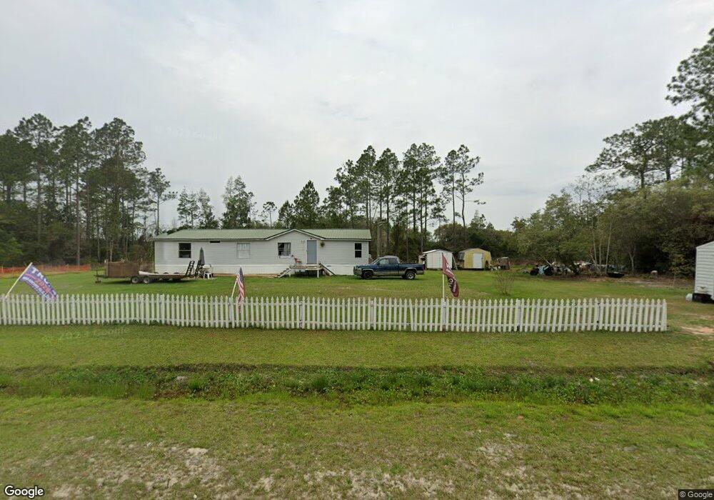
11173 Browntown Rd Hortense, GA 31543
Estimated Value: $55,897 - $181,000
3
Beds
2
Baths
1,680
Sq Ft
$61/Sq Ft
Est. Value
About This Home
This home is located at 11173 Browntown Rd, Hortense, GA 31543 and is currently estimated at $101,974, approximately $60 per square foot. 11173 Browntown Rd is a home with nearby schools including Waynesville Primary School, Atkinson Elementary School, and Brantley County Middle School.
Ownership History
Date
Name
Owned For
Owner Type
Purchase Details
Closed on
Mar 30, 2016
Sold by
Great Investments Of Georg
Bought by
Br Ronald Bradt and Br Ronald Meredith
Current Estimated Value
Home Financials for this Owner
Home Financials are based on the most recent Mortgage that was taken out on this home.
Original Mortgage
$44,900
Outstanding Balance
$19,622
Interest Rate
3.64%
Mortgage Type
New Conventional
Estimated Equity
$82,352
Purchase Details
Closed on
Oct 23, 2015
Sold by
Ameris Bank
Bought by
Great Investments Of Georgia I
Purchase Details
Closed on
Sep 17, 2015
Sold by
Southern Pines Investments
Bought by
Ameris Bank
Purchase Details
Closed on
May 5, 2015
Sold by
Elkins Evelyn Janet
Bought by
Ameris Bank
Create a Home Valuation Report for This Property
The Home Valuation Report is an in-depth analysis detailing your home's value as well as a comparison with similar homes in the area
Home Values in the Area
Average Home Value in this Area
Purchase History
| Date | Buyer | Sale Price | Title Company |
|---|---|---|---|
| Br Ronald Bradt | $49,900 | -- | |
| Great Investments Of Georgia I | $12,155 | -- | |
| Ameris Bank | -- | -- | |
| Ameris Bank | $11,000 | -- |
Source: Public Records
Mortgage History
| Date | Status | Borrower | Loan Amount |
|---|---|---|---|
| Open | Br Ronald Bradt | $44,900 |
Source: Public Records
Tax History Compared to Growth
Tax History
| Year | Tax Paid | Tax Assessment Tax Assessment Total Assessment is a certain percentage of the fair market value that is determined by local assessors to be the total taxable value of land and additions on the property. | Land | Improvement |
|---|---|---|---|---|
| 2024 | $176 | $4,740 | $3,080 | $1,660 |
| 2023 | $124 | $2,980 | $1,320 | $1,660 |
| 2022 | $94 | $7,598 | $0 | $7,598 |
| 2021 | $95 | $6,766 | $0 | $6,766 |
| 2020 | $97 | $6,722 | $0 | $6,722 |
| 2019 | $97 | $7,215 | $0 | $7,215 |
| 2018 | $244 | $7,215 | $0 | $7,215 |
| 2017 | $244 | $7,215 | $0 | $7,215 |
| 2016 | $133 | $6,611 | $0 | $6,611 |
Source: Public Records
Map
Nearby Homes
- 288 Rattler Run
- 0 Rattler Run
- 277 Carl Burney Rd
- 235 Gibson Cir
- 647 Gibson Cir
- 43 Dutch Rd
- 2101 Albert Gibson Rd
- 00 Hwy #32 Hwy #99 Tract 1
- 00 Hwy #32 Hwy #99 Tract 2
- 7535 Browntown Rd
- 3069 Mineral Springs Rd
- 0 Post Rd Unit 1648928
- 11211 Georgia 110
- 0 Heritage Cir Unit 1655955
- 0 Heritage Cir Unit 1656067
- 0 Heritage Cir Unit 1655952
- 0 Heritage Cir Unit 1656069
- 0 Heritage Cir Unit 1656065
- 45 Heritage Cir
- Off Dogwood Rd
- 55 Pine Court Rd
- 11115 Browntown Rd
- 26 Pine Court Rd
- 58 Pine Court Rd
- 11055 Browntown Rd
- 21 Glyndale Dr
- 183 Dusty Trail
- 90 Little Dusty Trail
- 11362 Browntown Rd
- 183 Little Dusty Trail
- 10931 Browntown Rd
- 00 Scattered Pines Rd
- 10875 Browntown Rd
- 115 Scattered Pines Rd
- 173 Scattered Pines Rd
- 746 Scattered Pines Rd
- 209 Scattered Pines Rd
- 11609 Browntown Rd
- 10705 Browntown Rd