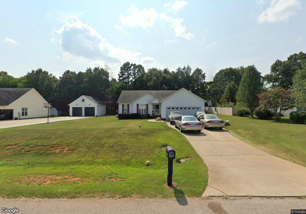
1118 Landsdown Dr Salisbury, NC 28147
Estimated Value: $298,000 - $350,000
Studio
3
Baths
1,636
Sq Ft
$191/Sq Ft
Est. Value
About This Home
This home is located at 1118 Landsdown Dr, Salisbury, NC 28147 and is currently estimated at $312,357, approximately $190 per square foot. 1118 Landsdown Dr is a home located in Rowan County with nearby schools including Hurley Elementary School, North Rowan Middle School, and Salisbury High School.
Ownership History
Date
Name
Owned For
Owner Type
Purchase Details
Closed on
Oct 14, 2004
Sold by
Inglis Ronald and Inglis Cynthia Burris
Bought by
Inglis Ronald and Inglis Cynthia Burris
Current Estimated Value
Home Financials for this Owner
Home Financials are based on the most recent Mortgage that was taken out on this home.
Original Mortgage
$132,541
Interest Rate
5.71%
Mortgage Type
FHA
Create a Home Valuation Report for This Property
The Home Valuation Report is an in-depth analysis detailing your home's value as well as a comparison with similar homes in the area
Purchase History
| Date | Buyer | Sale Price | Title Company |
|---|---|---|---|
| Inglis Ronald | -- | -- |
Source: Public Records
Mortgage History
| Date | Status | Borrower | Loan Amount |
|---|---|---|---|
| Closed | Inglis Ronald | $132,541 |
Source: Public Records
Tax History
| Year | Tax Paid | Tax Assessment Tax Assessment Total Assessment is a certain percentage of the fair market value that is determined by local assessors to be the total taxable value of land and additions on the property. | Land | Improvement |
|---|---|---|---|---|
| 2025 | $1,615 | $238,356 | $31,500 | $206,856 |
| 2024 | $1,615 | $238,356 | $31,500 | $206,856 |
| 2023 | $1,615 | $238,356 | $31,500 | $206,856 |
| 2022 | $1,206 | $159,751 | $25,500 | $134,251 |
| 2021 | $1,194 | $159,751 | $25,500 | $134,251 |
| 2020 | $1,194 | $159,751 | $25,500 | $134,251 |
| 2019 | $1,194 | $159,751 | $25,500 | $134,251 |
| 2018 | $1,005 | $135,592 | $25,500 | $110,092 |
| 2017 | $1,005 | $135,592 | $25,500 | $110,092 |
| 2016 | $1,005 | $135,592 | $25,500 | $110,092 |
| 2015 | $1,017 | $135,592 | $25,500 | $110,092 |
| 2014 | $979 | $136,985 | $25,500 | $111,485 |
Source: Public Records
Map
Nearby Homes
- 223 Wendover Dr
- 473 Wendover Dr
- 151 Falling Up Ln
- 142 Early Bird Ln
- 157 Falling Up Ln
- 136 Early Bird Ln
- 130 Early Bird Ln
- 146 Falling Up Ln
- 150 Early Bird Ln
- 236 Early Bird Ln
- 165 Backward Bill Dr
- 151 Backward Bill Dr
- 137 Backward Bill Dr
- 435 Frozen Dream Dr
- 441 Frozen Dream Dr
- 460 Frozen Dream Dr
- 430 Frozen Dream Dr
- 175 Superstar St
- 185 Superstar St
- 340 Freedom Dr
- 1074 Landsdown Dr
- 1162 Landsdown Dr
- 1078 Landsdown Dr
- 1115 Landsdown Dr
- 1095 Landsdown Dr
- 1137 Landsdown Dr
- 1184 Landsdown Dr
- 1056 Landsdown Dr
- 1073 Landsdown Dr
- 1155 Landsdown Dr
- 1047 Landsdown Dr
- 1202 Landsdown Dr
- 1034 Landsdown Dr
- 1177 Landsdown Dr
- 1199 Landsdown Dr
- 332 Wendover Dr Unit 71
- 1224 Landsdown Dr
- 374 Wendover Dr Unit 73
- 220 Wendover Dr
- 314 Wendover Dr
Your Personal Tour Guide
Ask me questions while you tour the home.