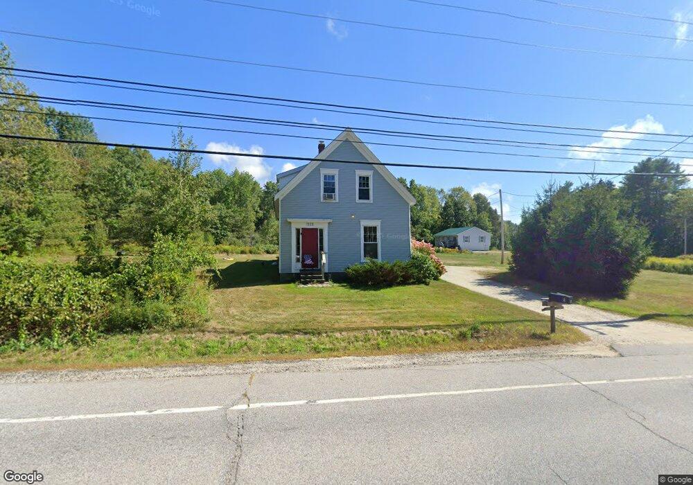
1118 Us Route 1 Freeport, ME 04032
Estimated Value: $435,727 - $589,000
4
Beds
2
Baths
1,659
Sq Ft
$299/Sq Ft
Est. Value
About This Home
This home is located at 1118 Us Route 1, Freeport, ME 04032 and is currently estimated at $496,576, approximately $299 per square foot. 1118 Us Route 1 is a home located in Cumberland County with nearby schools including Morse Street School, Mast Landing School, and Freeport Middle School.
Ownership History
Date
Name
Owned For
Owner Type
Purchase Details
Closed on
Sep 26, 2025
Sold by
Murphy Alice H
Bought by
Murphy Susan H
Current Estimated Value
Purchase Details
Closed on
Sep 30, 2022
Sold by
Murphy Susan H
Bought by
Murphy Susan H and Murphy Alice H
Purchase Details
Closed on
Aug 29, 2006
Sold by
Chaney John A and Chaney Judith A
Bought by
Murphy Susan H
Create a Home Valuation Report for This Property
The Home Valuation Report is an in-depth analysis detailing your home's value as well as a comparison with similar homes in the area
Home Values in the Area
Average Home Value in this Area
Purchase History
| Date | Buyer | Sale Price | Title Company |
|---|---|---|---|
| Murphy Susan H | -- | -- | |
| Murphy Susan H | -- | None Available | |
| Murphy Susan H | -- | -- | |
| Murphy Susan H | -- | -- |
Source: Public Records
Tax History
| Year | Tax Paid | Tax Assessment Tax Assessment Total Assessment is a certain percentage of the fair market value that is determined by local assessors to be the total taxable value of land and additions on the property. | Land | Improvement |
|---|---|---|---|---|
| 2025 | $4,149 | $299,600 | $143,200 | $156,400 |
| 2024 | $3,909 | $292,800 | $136,400 | $156,400 |
| 2023 | $3,582 | $260,500 | $124,000 | $136,500 |
| 2022 | $3,236 | $237,100 | $100,600 | $136,500 |
| 2021 | $3,165 | $237,100 | $100,600 | $136,500 |
| 2020 | $3,084 | $220,300 | $93,200 | $127,100 |
| 2019 | $2,947 | $206,100 | $87,900 | $118,200 |
| 2018 | $2,841 | $188,800 | $79,400 | $109,400 |
| 2017 | $2,724 | $182,200 | $77,800 | $104,400 |
| 2016 | $2,670 | $169,000 | $72,100 | $96,900 |
| 2015 | $2,592 | $154,300 | $68,400 | $85,900 |
| 2014 | $2,438 | $154,300 | $68,400 | $85,900 |
| 2013 | $2,170 | $136,900 | $68,400 | $68,500 |
Source: Public Records
Map
Nearby Homes
- 30 Meadow Ln Unit 8
- 1260 Us Route 1
- 1 Wardtown Rd
- 10 Prout Rd
- 42 Durham Rd
- 10 Durham Rd
- 60 Pleasant Hill Rd
- 8 Statler Ln
- 0 Prout Rd
- 2 Renee Rd
- 108 Baker Rd
- 64 Wardtown Rd
- 15 Linwood Rd Unit 15
- 304 Pownal Rd
- 321 Pownal Rd
- 52 Birch Point Rd
- 42A Wardtown Rd
- 4 Harper's Trail
- 26 Harvest Ridge Rd Unit 24
- 29 S Freeport Rd
- 1126 Us Route 1
- 5 Upper Mast Landing Rd
- 0 Upper Mast Landing
- 1131 Us Route 1
- 0 Us Route 1 (North) Unit 1292882
- 9 Upper Mast Landing Rd
- 1099 Us Route 1
- 1096 Us Route 1
- 1094 Us Route 1
- 3 Wood Thrush Ln
- 8 Upper Mast Landing Rd
- TBB Lot C Little Round Top Run
- 1154 Us Route 1
- TBD Us Route One Route
- 15 Upper Mast Landing Rd
- 0 Us Route One Route Unit 1294604
- 1085 Us Route 1
- 1085 U S Route One
- 2 Wood Thrush Ln
- 20 Noble Dr
Your Personal Tour Guide
Ask me questions while you tour the home.