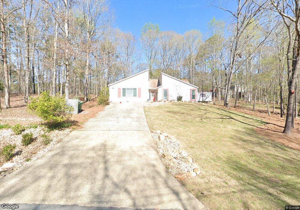
1119 Canvas Back Dr Woodstock, GA 30189
Sutallee NeighborhoodEstimated Value: $339,000 - $470,000
3
Beds
2
Baths
2,180
Sq Ft
$185/Sq Ft
Est. Value
About This Home
This home is located at 1119 Canvas Back Dr, Woodstock, GA 30189 and is currently estimated at $403,122, approximately $184 per square foot. 1119 Canvas Back Dr is a home located in Cherokee County with nearby schools including Boston Elementary School, E. T. Booth Middle School, and Etowah High School.
Ownership History
Date
Name
Owned For
Owner Type
Purchase Details
Closed on
Dec 3, 2012
Sold by
Bouse Adan Neale
Bought by
Hoffman Donna Elizabeth
Current Estimated Value
Purchase Details
Closed on
Aug 31, 2007
Sold by
Wolverton Randy and Wolverton Ruth
Bought by
Bouse Adam N
Home Financials for this Owner
Home Financials are based on the most recent Mortgage that was taken out on this home.
Original Mortgage
$129,000
Interest Rate
6.65%
Mortgage Type
Trade
Purchase Details
Closed on
Jul 11, 2003
Sold by
Belgard Barry and Belgard Aimee S
Bought by
Wolverton Randy and Wolverton Ruth
Create a Home Valuation Report for This Property
The Home Valuation Report is an in-depth analysis detailing your home's value as well as a comparison with similar homes in the area
Home Values in the Area
Average Home Value in this Area
Purchase History
| Date | Buyer | Sale Price | Title Company |
|---|---|---|---|
| Hoffman Donna Elizabeth | $145,000 | -- | |
| Bouse Adam N | $145,000 | -- | |
| Wolverton Randy | $129,000 | -- |
Source: Public Records
Mortgage History
| Date | Status | Borrower | Loan Amount |
|---|---|---|---|
| Previous Owner | Bouse Adam N | $129,000 |
Source: Public Records
Tax History Compared to Growth
Tax History
| Year | Tax Paid | Tax Assessment Tax Assessment Total Assessment is a certain percentage of the fair market value that is determined by local assessors to be the total taxable value of land and additions on the property. | Land | Improvement |
|---|---|---|---|---|
| 2024 | $623 | $137,980 | $29,200 | $108,780 |
| 2023 | $545 | $157,620 | $29,200 | $128,420 |
| 2022 | $620 | $125,960 | $26,000 | $99,960 |
| 2021 | $542 | $89,580 | $19,480 | $70,100 |
| 2020 | $513 | $81,120 | $17,400 | $63,720 |
| 2019 | $462 | $67,600 | $15,000 | $52,600 |
| 2018 | $456 | $64,080 | $13,600 | $50,480 |
| 2017 | $468 | $160,700 | $13,600 | $50,680 |
| 2016 | $469 | $152,100 | $11,760 | $49,080 |
| 2015 | $457 | $136,500 | $11,760 | $42,840 |
| 2014 | $437 | $124,400 | $11,760 | $38,000 |
Source: Public Records
Map
Nearby Homes
- 306 N Briar Ridge
- 0 Black Oak Trail Unit 10267626
- 0 Black Oak Trail Unit 7303191
- 313 Maltibe Dr
- 477 Victoria Rd
- 308 Mainsail Ln
- 314 Bethel Dr
- 146 Sunset Ln
- 617 Driftwood Dr
- 7119 Big Woods Dr
- 507 Huntgate Rd
- 204 Captains Quarters
- 104 Rose Cottage Ln Unit 65
- 7307 Carriage Creek Rd
- 819 Victoria Place
- 124 Dockside Downs Dr
- 923 Pine Cir
- 1001 Deer Hollow Dr
- 1304 Bass Dr
- 1117 Canvas Back Dr
- 1302 Bass Dr
- 1306 Bass Dr
- 1130 Canvas Back Dr
- 1121 Canvas Back Dr
- 0 Bass Dr
- 1305 Bass Dr
- 1126 Canvas Back Dr
- 1113 Canvas Back Dr
- 1111 Canvas Back Dr
- 1308 Bass Dr
- 1307 Bass Dr
- 1124 Canvas Back Dr
- 1301 Bass Dr
- 1310 Bass Dr
- 1309 Bass Dr
- 1204 Trout Dr
- 1206 Trout Dr
- 0 Canvas Back Dr Unit 7465052