
Seller's Agent in 2026
Adriane Dundon
The Agency Hall & Hunter
(248) 838-8821
10 in this area
85 Total Sales
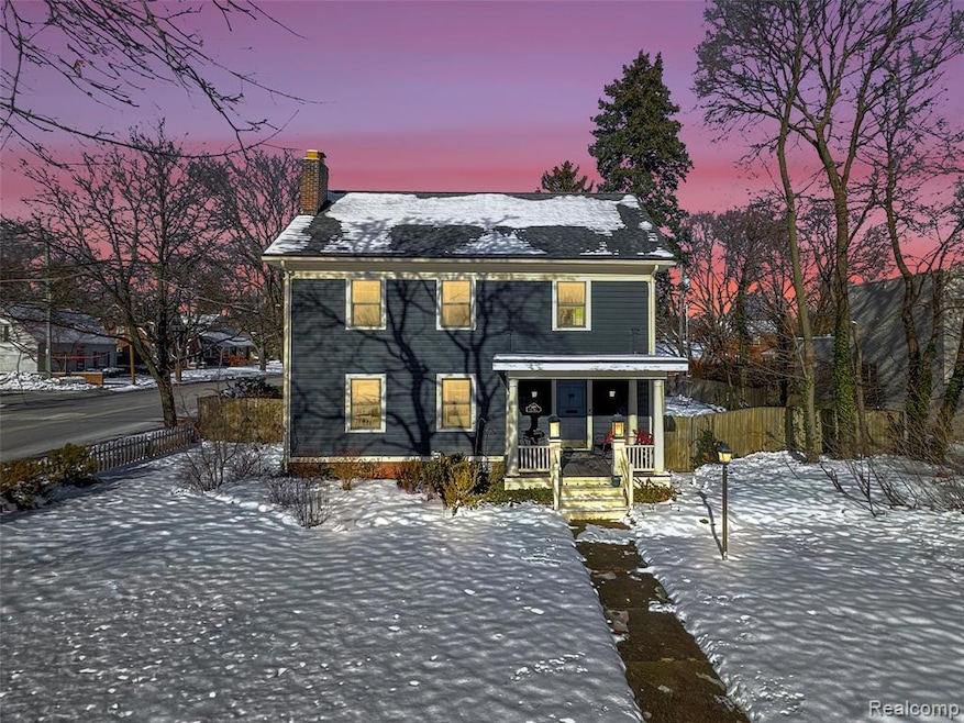
Charming 1920s Birmingham Colonial with character & modern updates is ready for you! Wonderful opportunities await in this spacious three-story vintage colonial filled with timeless charm and great potential! Step inside to refinished hardwood floors, a welcoming living room with ornamental moldings, cozy fireplace, and elegant beveled French doors leading to a large, bright, and updated kitchen. Kitchen features stainless steel appliances and granite countertops, offering an ideal flow for everyday living and entertaining. Kitchen leads into a dining room with access to the beautiful back yard! Upstairs to the second level you will find 3 bedrooms and a main hall bath featuring a classic clawfoot tub. The convenient second-floor laundry enhances everyday comfort. The third level offers a unique primary suite with its own full bath, perfect for added privacy. Situated on an oversized lot, the beautiful and private backyard is fully fenced and complemented by a 2-car garage. Major updates include: New Roof (2023), Newer windows (2017), HWH (2017), Boiler system (2005) & Exterior Painting, giving peace of mind for years to come. With its close proximity to downtown Birmingham and all it has to offer, along with the highly desirable Birmingham Schools district, this classic home, blending historic character with modern enhancements, is ready for its next chapter!
Last Agent to Sell the Property
The Agency Hall & Hunter License #6501383741 Listed on: 12/12/2025
| Date | Type | Sale Price | Title Company |
|---|---|---|---|
| Warranty Deed | $527,500 | Equity Title | |
| Interfamily Deed Transfer | -- | None Available | |
| Quit Claim Deed | -- | None Available | |
| Sheriffs Deed | $140,000 | None Available | |
| Sheriffs Deed | $399,900 | None Available | |
| Warranty Deed | $430,000 | Title One Inc | |
| Deed | -- | -- |
| Date | Status | Loan Amount | Loan Type |
|---|---|---|---|
| Previous Owner | $152,421 | FHA | |
| Previous Owner | $408,500 | Purchase Money Mortgage | |
| Previous Owner | $105,000 | No Value Available |
| Date | Event | Price | List to Sale | Price per Sq Ft |
|---|---|---|---|---|
| 01/09/2026 01/09/26 | Sold | $527,500 | -1.4% | $211 / Sq Ft |
| 12/23/2025 12/23/25 | Pending | -- | -- | -- |
| 12/12/2025 12/12/25 | For Sale | $534,900 | -- | $214 / Sq Ft |
| Year | Tax Paid | Tax Assessment Tax Assessment Total Assessment is a certain percentage of the fair market value that is determined by local assessors to be the total taxable value of land and additions on the property. | Land | Improvement |
|---|---|---|---|---|
| 2025 | $5,588 | $195,170 | $0 | $0 |
| 2024 | $4,933 | $179,820 | $0 | $0 |
| 2023 | $4,728 | $179,450 | $0 | $0 |
| 2022 | $5,069 | $178,590 | $0 | $0 |
| 2021 | $5,114 | $174,520 | $0 | $0 |
| 2020 | $4,557 | $167,260 | $0 | $0 |
| 2019 | $5,157 | $154,750 | $0 | $0 |
| 2018 | $5,118 | $151,390 | $0 | $0 |
| 2017 | $5,109 | $147,850 | $0 | $0 |
| 2016 | $5,118 | $144,430 | $0 | $0 |
| 2015 | -- | $133,050 | $0 | $0 |
| 2014 | -- | $114,550 | $0 | $0 |
| 2011 | -- | $112,100 | $0 | $0 |
Seller's Agent in 2026
Adriane Dundon
The Agency Hall & Hunter
(248) 838-8821
10 in this area
85 Total Sales
Seller Co-Listing Agent in 2026
Meredith Colburn
The Agency Hall & Hunter
(248) 762-5319
62 in this area
250 Total Sales
Buyer's Agent in 2026
Wanda Williams
(586) 215-9375
2 in this area
124 Total Sales
Source: Realcomp
MLS Number: 20251059078
APN: 20-30-353-011
Disclaimer: Certain information contained herein is derived from information provided by parties other than Homes.com. All information provided is deemed reliable, but is not guaranteed to be accurate and should be independently verified.
![]() IDX provided courtesy of Realcomp II Ltd. via Ten-X and MLS
IDX provided courtesy of Realcomp II Ltd. via Ten-X and MLS
Copyright 2026 Realcomp II Ltd. Shareholders
IDX information is provided exclusively for consumers' personal, noncommercial use and may not be used for any purpose other than to identify prospective properties consumers may be interested in purchasing. The accuracy of all information, regardless of source, is not guaranteed or warranted. All information should be independently verified.
Listing Information presented by local MLS brokerage: Ten-X, local REALTOR®- Arlene Richardson - (888)-952-6393
Ask me questions while you tour the home.