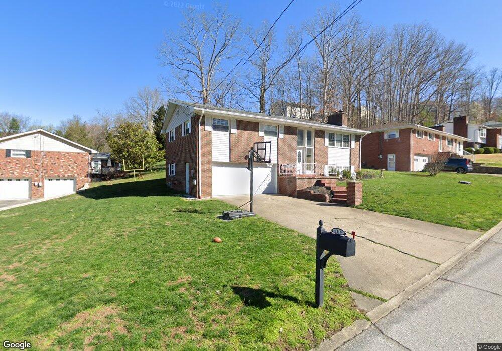
1119 Shamrock Rd Charleston, WV 25314
South Hills NeighborhoodEstimated Value: $252,000 - $284,000
3
Beds
3
Baths
2,212
Sq Ft
$122/Sq Ft
Est. Value
About This Home
This home is located at 1119 Shamrock Rd, Charleston, WV 25314 and is currently estimated at $270,699, approximately $122 per square foot. 1119 Shamrock Rd is a home located in Kanawha County with nearby schools including Kenna Elementary School, John Adams Middle School, and George Washington High School.
Ownership History
Date
Name
Owned For
Owner Type
Purchase Details
Closed on
Oct 27, 2006
Sold by
Tyree Lewis F
Bought by
Kinder Shannon W and Nicoloudakis,Katerina
Current Estimated Value
Home Financials for this Owner
Home Financials are based on the most recent Mortgage that was taken out on this home.
Original Mortgage
$130,000
Outstanding Balance
$77,259
Interest Rate
6.48%
Mortgage Type
New Conventional
Estimated Equity
$193,440
Purchase Details
Closed on
Sep 7, 2001
Sold by
Moore Ruth
Bought by
Tyree Lewis
Create a Home Valuation Report for This Property
The Home Valuation Report is an in-depth analysis detailing your home's value as well as a comparison with similar homes in the area
Home Values in the Area
Average Home Value in this Area
Purchase History
| Date | Buyer | Sale Price | Title Company |
|---|---|---|---|
| Kinder Shannon W | $168,000 | -- | |
| Tyree Lewis | $48,000 | -- |
Source: Public Records
Mortgage History
| Date | Status | Borrower | Loan Amount |
|---|---|---|---|
| Open | Kinder Shannon W | $130,000 |
Source: Public Records
Tax History Compared to Growth
Tax History
| Year | Tax Paid | Tax Assessment Tax Assessment Total Assessment is a certain percentage of the fair market value that is determined by local assessors to be the total taxable value of land and additions on the property. | Land | Improvement |
|---|---|---|---|---|
| 2025 | $2,176 | $135,240 | $25,320 | $109,920 |
| 2024 | $2,176 | $118,980 | $25,320 | $93,660 |
| 2023 | $1,914 | $118,980 | $25,320 | $93,660 |
| 2022 | $1,914 | $118,980 | $25,320 | $93,660 |
| 2021 | $1,734 | $108,180 | $25,320 | $82,860 |
| 2020 | $1,718 | $108,180 | $25,320 | $82,860 |
| 2019 | $1,726 | $109,320 | $25,320 | $84,000 |
| 2018 | $1,561 | $109,320 | $25,320 | $84,000 |
| 2017 | $1,567 | $110,460 | $25,320 | $85,140 |
| 2016 | $1,559 | $110,520 | $25,320 | $85,200 |
| 2015 | $1,562 | $111,600 | $25,320 | $86,280 |
| 2014 | $1,516 | $110,340 | $25,320 | $85,020 |
Source: Public Records
Map
Nearby Homes
- 207 Branchfield Dr
- 1 Bridlewood Rd
- 1130 Lyndale Dr
- 1941 Olympus Rd
- 0 Lyndale Dr
- 1603 Colby Rd
- 1797 Huber Rd
- 1233 Lyndale Dr
- 1570 Smith Rd
- 266 Oakwood Rd
- 1986 Parkwood Rd
- 1520 Knob Rd
- 263 Oakwood Rd
- 1501 Knob Rd
- 836 Walters Rd
- 1239 Paula Rd
- 1211 Ellen Dr
- 1302 Hunters Ridge Rd
- 924 Harmony Ln
- 2145 Smith Rd
- 1121 Shamrock Rd
- 1117 Shamrock Rd
- 1118 Shamrock Rd
- 1127 Londonderry Rd
- 1123 Shamrock Rd
- 1120 Shamrock Rd
- 1122 Shamrock Rd
- 1115 Shamrock Rd
- 1124 Shamrock Rd
- 1116 Shamrock Rd
- 1125 Shamrock Rd
- 1121 Londonderry Rd
- 1114 Shamrock Rd
- 1126 Shamrock Rd
- 1112 Shamrock Rd
- 1827 Devondale Cir
- 1829 Devondale Cir
- 1120 Londonderry Rd
- 1115 Londonderry Rd
- 1825 Devondale Cir