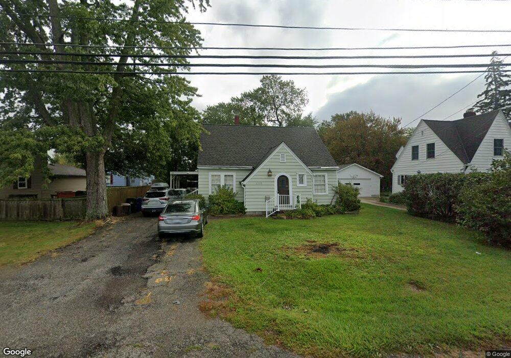
1119 State St Vermilion, OH 44089
Estimated Value: $163,514 - $246,000
2
Beds
1
Bath
1,496
Sq Ft
$127/Sq Ft
Est. Value
About This Home
This home is located at 1119 State St, Vermilion, OH 44089 and is currently estimated at $190,629, approximately $127 per square foot. 1119 State St is a home located in Erie County with nearby schools including Vermilion Elementary School, Sailorway Middle School, and Vermilion High School.
Ownership History
Date
Name
Owned For
Owner Type
Purchase Details
Closed on
Jan 10, 2023
Sold by
Yagley Michael J and Yagley Maria A
Bought by
Yagley Michael J and Yagley Maria A
Current Estimated Value
Purchase Details
Closed on
Oct 13, 2006
Sold by
Turk Craig A
Bought by
Bank Of New York
Purchase Details
Closed on
Feb 15, 2002
Sold by
Fischer Iva B
Bought by
Turk Craig A and Turk Janet L
Home Financials for this Owner
Home Financials are based on the most recent Mortgage that was taken out on this home.
Original Mortgage
$86,275
Interest Rate
7.23%
Mortgage Type
FHA
Create a Home Valuation Report for This Property
The Home Valuation Report is an in-depth analysis detailing your home's value as well as a comparison with similar homes in the area
Home Values in the Area
Average Home Value in this Area
Purchase History
| Date | Buyer | Sale Price | Title Company |
|---|---|---|---|
| Yagley Michael J | -- | None Listed On Document | |
| Bank Of New York | $75,000 | None Available | |
| Turk Craig A | $101,000 | -- |
Source: Public Records
Mortgage History
| Date | Status | Borrower | Loan Amount |
|---|---|---|---|
| Previous Owner | Turk Craig A | $86,275 |
Source: Public Records
Tax History
| Year | Tax Paid | Tax Assessment Tax Assessment Total Assessment is a certain percentage of the fair market value that is determined by local assessors to be the total taxable value of land and additions on the property. | Land | Improvement |
|---|---|---|---|---|
| 2024 | $1,720 | $39,238 | $5,894 | $33,344 |
| 2023 | $1,728 | $34,180 | $5,358 | $28,822 |
| 2022 | $1,641 | $34,184 | $5,358 | $28,826 |
| 2021 | $1,632 | $34,190 | $5,360 | $28,830 |
| 2020 | $1,371 | $28,090 | $5,360 | $22,730 |
| 2019 | $1,419 | $28,090 | $5,360 | $22,730 |
| 2018 | $1,421 | $28,090 | $5,360 | $22,730 |
| 2017 | $1,372 | $26,800 | $6,830 | $19,970 |
| 2016 | $1,364 | $26,800 | $6,830 | $19,970 |
| 2015 | $1,346 | $26,800 | $6,830 | $19,970 |
| 2014 | $1,355 | $26,800 | $6,830 | $19,970 |
| 2013 | $1,339 | $26,800 | $6,830 | $19,970 |
Source: Public Records
Map
Nearby Homes
- 1106 State St
- 940 Douglas St
- 6012 Conneaut Light Dr
- 5937 Cape Hatteras
- 856 Tappan Cir
- 5993 Montauk Point
- 1123 Adams St
- 629 Main St
- 599 Main St
- 4972 Northview Ct
- 1019 Jackson St
- 0 Liberty Ave Unit 20252085
- 5015 Park Dr
- 14015 W Lake Rd
- 4861 Woodview Dr
- 4829 Woodview Dr
- 4613 Compass Rose Unit 10
- 4607 Compass Rose Unit 13
- 1480 Forestview Dr
- 0 V L 3 Gardiner Dr
Your Personal Tour Guide
Ask me questions while you tour the home.