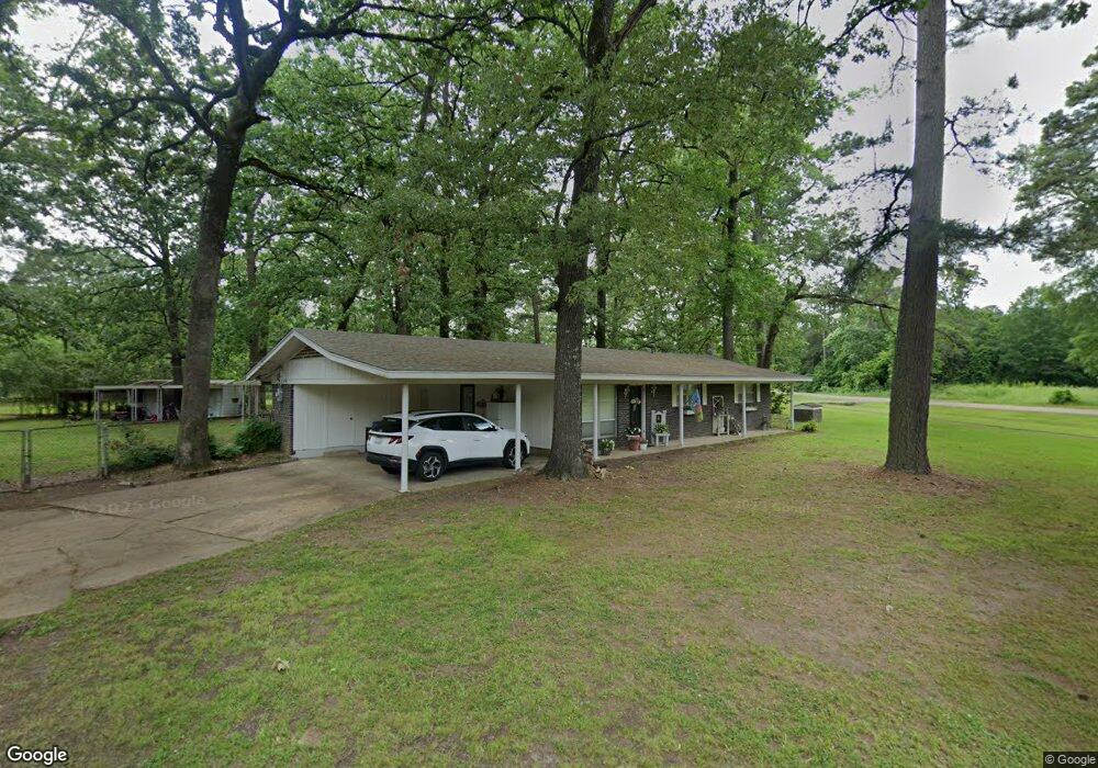
112 Cummings Ln Texarkana, TX 75501
Estimated Value: $153,421 - $172,000
3
Beds
1
Bath
1,175
Sq Ft
$139/Sq Ft
Est. Value
About This Home
This home is located at 112 Cummings Ln, Texarkana, TX 75501 and is currently estimated at $163,855, approximately $139 per square foot. 112 Cummings Ln is a home located in Bowie County with nearby schools including Liberty-Eylau Early Childhood Center, Liberty-Eylau C.K. Bender Elementary Campus, and Liberty-Eylau Primary School.
Ownership History
Date
Name
Owned For
Owner Type
Purchase Details
Closed on
Aug 18, 2016
Sold by
Brown Mark T
Bought by
Shipp Debra D
Current Estimated Value
Home Financials for this Owner
Home Financials are based on the most recent Mortgage that was taken out on this home.
Original Mortgage
$87,352
Outstanding Balance
$69,448
Interest Rate
3.37%
Mortgage Type
FHA
Estimated Equity
$94,407
Create a Home Valuation Report for This Property
The Home Valuation Report is an in-depth analysis detailing your home's value as well as a comparison with similar homes in the area
Home Values in the Area
Average Home Value in this Area
Purchase History
| Date | Buyer | Sale Price | Title Company |
|---|---|---|---|
| Shipp Debra D | -- | Twin City Title Company |
Source: Public Records
Mortgage History
| Date | Status | Borrower | Loan Amount |
|---|---|---|---|
| Open | Shipp Debra D | $87,352 |
Source: Public Records
Tax History Compared to Growth
Tax History
| Year | Tax Paid | Tax Assessment Tax Assessment Total Assessment is a certain percentage of the fair market value that is determined by local assessors to be the total taxable value of land and additions on the property. | Land | Improvement |
|---|---|---|---|---|
| 2025 | $2,028 | $140,744 | $16,000 | $124,744 |
| 2024 | $2,028 | $137,268 | $16,000 | $121,268 |
| 2023 | $1,922 | $128,650 | $16,000 | $112,650 |
| 2022 | $2,018 | $117,129 | $16,000 | $101,129 |
| 2021 | $1,761 | $96,121 | $12,500 | $83,621 |
| 2020 | $1,703 | $92,265 | $12,500 | $79,765 |
| 2019 | $1,721 | $88,593 | $12,500 | $76,093 |
| 2018 | $1,666 | $85,764 | $12,500 | $73,264 |
| 2017 | $1,672 | $86,414 | $12,500 | $73,914 |
| 2016 | $1,672 | $86,414 | $12,500 | $73,914 |
| 2015 | $1,002 | $85,717 | $12,500 | $73,217 |
| 2014 | $1,002 | $81,471 | $12,500 | $68,971 |
Source: Public Records
Map
Nearby Homes
- 101 Redwood Dr
- 6514 Buchanan Loop Rd
- 403 Brookfield St
- 194 W Starlite Dr
- 280 Patriot Way
- 6815 Buchanan Loop Rd
- 6 Southridge St
- 0 Randall Rd
- 2043 Randall Rd
- 6606 Us-59
- 6606 Us Highway 59 S
- lot15 B2 Quail Brook
- lot15 B1 Quail Brook
- lot14 B2 Quail Brook
- Lot 1 B2 Quail Brook
- 39 Quail Brook Dr
- 144 Joe Tyl Rd
- 7689 Us-59
- 7685 State Highway 59
- 5789 U S 59
- 110 Cummings Ln
- 200 Cummings Ln
- 111 Redwood Dr
- 108 Cummings Ln
- 121 Cummings Ln
- 109 Redwood Dr
- 201 Redwood Dr
- 107 Redwood Dr
- 203 Redwood Dr
- 106 Cummings Ln
- 206 Cummings Ln
- 105 Redwood Dr
- 205 Redwood Dr
- 104 Cummings Ln
- 112 Redwood Dr
- 208 Cummings Ln
- 110 Redwood Dr
- 202 Redwood Dr
- 103 Redwood Dr
- 207 Redwood Dr