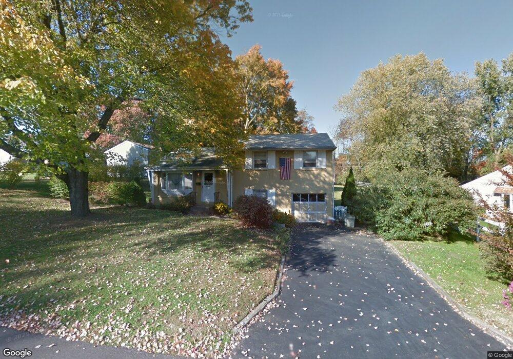
112 Delwhit Dr Feasterville Trevose, PA 19053
Estimated Value: $403,846 - $483,000
3
Beds
2
Baths
1,132
Sq Ft
$386/Sq Ft
Est. Value
About This Home
This home is located at 112 Delwhit Dr, Feasterville Trevose, PA 19053 and is currently estimated at $437,212, approximately $386 per square foot. 112 Delwhit Dr is a home located in Bucks County with nearby schools including Tawanka Elementary School, Poquessing Middle School, and Neshaminy High School.
Ownership History
Date
Name
Owned For
Owner Type
Purchase Details
Closed on
Jun 26, 2025
Sold by
Sonnie Earl R and Sonnie Eileen
Bought by
Sonnie Eileen
Current Estimated Value
Purchase Details
Closed on
Jul 11, 2003
Sold by
Sonnie Earl R and Sonnie Margaret M
Bought by
Sonnie Earl R
Purchase Details
Closed on
Dec 13, 1954
Bought by
Sonnie Earl R and Sonnie Margaret M
Create a Home Valuation Report for This Property
The Home Valuation Report is an in-depth analysis detailing your home's value as well as a comparison with similar homes in the area
Home Values in the Area
Average Home Value in this Area
Purchase History
| Date | Buyer | Sale Price | Title Company |
|---|---|---|---|
| Sonnie Eileen | -- | None Listed On Document | |
| Sonnie Earl R | -- | -- | |
| Sonnie Earl R | -- | -- |
Source: Public Records
Tax History Compared to Growth
Tax History
| Year | Tax Paid | Tax Assessment Tax Assessment Total Assessment is a certain percentage of the fair market value that is determined by local assessors to be the total taxable value of land and additions on the property. | Land | Improvement |
|---|---|---|---|---|
| 2025 | $4,847 | $22,780 | $6,360 | $16,420 |
| 2024 | $4,847 | $22,780 | $6,360 | $16,420 |
| 2023 | $4,801 | $22,780 | $6,360 | $16,420 |
| 2022 | $4,673 | $22,780 | $6,360 | $16,420 |
| 2021 | $4,673 | $22,780 | $6,360 | $16,420 |
| 2020 | $4,616 | $22,780 | $6,360 | $16,420 |
| 2019 | $4,511 | $22,780 | $6,360 | $16,420 |
| 2018 | $4,427 | $22,780 | $6,360 | $16,420 |
| 2017 | $4,312 | $22,780 | $6,360 | $16,420 |
| 2016 | $4,312 | $22,780 | $6,360 | $16,420 |
| 2015 | $3,256 | $22,780 | $6,360 | $16,420 |
| 2014 | $3,256 | $22,780 | $6,360 | $16,420 |
Source: Public Records
Map
Nearby Homes
- 125 Fox Hollow Dr
- 428 Fox Hollow Dr
- 2067 Herrick Ave
- 415 Fox Hollow Dr
- 100 E Endfield Rd
- 24 Springmeadow Rd
- 111 E Endfield Rd
- 235 Andrews Rd
- 2304 Brownsville Rd Unit L22
- 2304 Brownsville Rd Unit P11
- 2304 Brownsville Rd
- 2304 Brownsville Rd Unit 1216
- 517 Somers Ave
- 2053 Christina Ct
- 4357 Brownsville Rd
- 1700 Colonial Dr
- 1 Falcon Dr Unit 203
- 722 Autumn Dr
- 2 Falcon Dr Unit 202
- 836 E Bristol Rd
- 2041 Hillside Ave
- 104 Delwhit Dr
- 107 Delwhit Dr
- 120 Delwhit Dr
- 2045 Hillside Ave
- 111 Delwhit Dr
- 105 Delwhit Dr
- 2049 Hillside Ave
- 129 Fox Hollow Dr
- 117 Delwhit Dr
- 101 Delwhit Dr
- 124 Delwhit Dr
- 131 Fox Hollow Dr
- 110 Berry Ln
- 2036 Shadybrook Ln
- 106 Berry Ln
- 2034 Hillside Ave
- 2053 Hillside Ave
- 127 Fox Hollow Dr
- 2049 Terrace Dr